File:Kościół Św. Wawrzyńca Męczennika - panoramio.jpg
From Wikimedia Commons, the free media repository
Jump to navigation
Jump to search
Size of this preview: 800 × 600 pixels. Other resolutions: 320 × 240 pixels | 640 × 480 pixels | 1,024 × 768 pixels | 1,280 × 960 pixels | 2,048 × 1,536 pixels.
Original file (2,048 × 1,536 pixels, file size: 1.22 MB, MIME type: image/jpeg)
File information
Structured data
Captions
Summary
[edit]DescriptionKościół Św. Wawrzyńca Męczennika - panoramio.jpg |
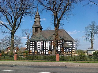
Polski: Brzezie - rzymskokatolicki kościół parafialny p.w. św. Wawrzyńca, 1812, 1923 (szachulcowy kościół z drewnianą wieżą) |
||
Date | Taken on 22 April 2011 | ||
Source | https://web.archive.org/web/20161021140207/http://www.panoramio.com/photo/51492755 | ||
Author | geo573 | ||
Permission (Reusing this file) |
This file is licensed under the Creative Commons Attribution 3.0 Unported license. Attribution: geo573
|
||
Tags (from Panoramio photo page) InfoField | Gmina Rzeczenica , Brzezie , Poland |
Camera location | 53° 50′ 11.58″ N, 16° 55′ 32.11″ E | View this and other nearby images on: OpenStreetMap | 53.836550; 16.925586 |
---|
File history
Click on a date/time to view the file as it appeared at that time.
Date/Time | Thumbnail | Dimensions | User | Comment | |
---|---|---|---|---|---|
current | 13:05, 20 November 2016 | 2,048 × 1,536 (1.22 MB) | Panoramio upload bot (talk | contribs) | == {{int:filedesc}} == {{Information |description=Kościół Św. Wawrzyńca Męczennika |date={{Taken on|2011-04-22}} |source=http://www.panoramio.com/photo/51492755 |author=[http://www.panoramio.com/user/1399169?with_photo_id=51492755 geo573] |permis... |
You cannot overwrite this file.
File usage on Commons
The following page uses this file:
Metadata
This file contains additional information such as Exif metadata which may have been added by the digital camera, scanner, or software program used to create or digitize it. If the file has been modified from its original state, some details such as the timestamp may not fully reflect those of the original file. The timestamp is only as accurate as the clock in the camera, and it may be completely wrong.
Camera manufacturer | Nokia |
---|---|
Camera model | C5-00 |
Exposure time | 14/15,625 sec (0.000896) |
F-number | f/2.4 |
ISO speed rating | 100 |
Date and time of data generation | 13:13, 22 April 2011 |
Lens focal length | 3.3 mm |
Latitude | 53° 50′ 10.71″ N |
Longitude | 16° 55′ 33.68″ E |
Altitude | 200 meters above sea level |
Orientation | Normal |
Horizontal resolution | 300 dpi |
Vertical resolution | 300 dpi |
Y and C positioning | Centered |
Exif version | 2.2 |
Date and time of digitizing | 13:13, 22 April 2011 |
Meaning of each component |
|
APEX shutter speed | 10.124 |
APEX aperture | 1.04 |
Light source | Unknown |
Flash | Flash did not fire, auto mode |
DateTime subseconds | 873 |
DateTimeOriginal subseconds | 873 |
DateTimeDigitized subseconds | 873 |
Supported Flashpix version | 1 |
Color space | sRGB |
Custom image processing | Normal process |
Exposure mode | Auto exposure |
White balance | Auto white balance |
Digital zoom ratio | 0 |
Scene capture type | Standard |
Scene control | None |
GPS tag version | 0.0.2.2 |
Structured data
Items portrayed in this file
depicts
53°50'11.580"N, 16°55'32.110"E
22 April 2011
0.000896 second
2.4
3.3 millimetre
100
image/jpeg
Hidden categories:
- Cultural heritage monuments in Poland with known IDs
- Cultural heritage monuments in Poland missing SDC depicts
- Cultural heritage monuments in Poland missing SDC location of creation
- Poland photographs taken on 2011-04-22
- CC-BY-3.0
- Panoramio images reviewed by trusted users
- Photos from Panoramio
- Files with coordinates missing SDC location of creation
- Panoramio files uploaded by Panoramio upload bot
- Photos from Panoramio ID 1399169
- Pages with maps