File:Koh administrative 1370 01.png
Μετάβαση στην πλοήγηση
Πήδηση στην αναζήτηση

Μέγεθος αυτής της προεπισκόπησης: 784 × 599 εικονοστοιχεία . Άλλες αναλύσεις: 314 × 240 εικονοστοιχεία | 628 × 480 εικονοστοιχεία | 1.005 × 768 εικονοστοιχεία | 1.228 × 939 εικονοστοιχεία.
Πρωτότυπο αρχείο (1.228 × 939 εικονοστοιχεία, μέγεθος αρχείου: 128 KB, τύπος MIME: image/png)
Λεζάντες
Λεζάντες
Δεν ορίστηκε λεζάντα
Σύνοψη[επεξεργασία]
| Περιγραφή |
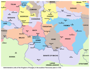
English: Administrative units of the Kingdom of Hungary in the southern Pannonian plain in 1370. Српски / srpski: Административне јединице Краљевине Угарске на југу Панонске низије 1370. године. |
| Ημερομηνία | |
| Πηγή | Έργο αυτού που το ανεβάζει |
| Δημιουργός | PANONIAN |
Αδειοδότηση[επεξεργασία]
Εγώ, ο κάτοχος των πνευματικών δικαιωμάτων αυτού του έργου, το δημοσιεύω δια του παρόντος υπό την εξής άδεια χρήσης:
| Το αρχείο αυτό έχει διατεθεί με Creative Commons CC0 1.0 Παγκόσμια Εκχώρηση Κοινού Κτήματος. | |
| Το πρόσωπο που συσχέτισε ένα έργο με αυτή την πράξη έχει απελευθερώσει αυτό το έργο στην δημόσια σφαίρα παραιτούμενος από όλα τα δικαιώματά του σε αυτό το έργο παγκοσμίως υπό τη νομοθεσία των πνευματικών δικαιωμάτων και όλα τα σχετικά ή παρεμφερή νόμιμα δικαιώματα που είχε στο έργο, στο εύρος που νόμος ορίζει. Έργα υπό την CC0 δεν χρειάζονται απόδοση. Όταν παραθέτετε το έργο, δε χρειάζεται να υπαινιχθείτε έγκριση από το συγγραφέα.
|
References[επεξεργασία]
Borders in the map are made in accordance with this reference:
Secondary references:
- The Times History of Europe, Times Books, London, 2002.
- Istorijski atlas, Geokarta, Beograd, 1999.
- Zbornik "Vojvodina", knjiga I, Fototipsko izdanje, Prometej, Novi Sad, 2008.
- [1] - Géza Pálffy, IZVANREDAN IZVOR O ZEMLJOPISNIM ZNANJIMA UGARSKO-HRVATSKE POLITIČKE ELITE 16. STOLJEĆA.
Ιστορικό αρχείου
Πατήστε σε μια ημερομηνία/ώρα για να δείτε το αρχείο όπως εμφανιζόταν εκείνη την χρονική στιγμή.
| Ημερομηνία/Ώρα | Μικρογραφία | Διαστάσεις | Χρήστης | Σχόλιο | |
|---|---|---|---|---|---|
| τρέχον | 12:08, 9 Μαρτίου 2020 | | 1.228 × 939 (128 KB) | PANONIAN (συζήτηση | Συνεισφορά) | Reverted to version as of 14:50, 20 May 2015 (UTC) - not according to my source |
| 16:41, 18 Φεβρουαρίου 2020 |  | 1.228 × 939 (108 KB) | Ceha (συζήτηση | Συνεισφορά) | Southern banates | |
| 14:50, 20 Μαΐου 2015 |  | 1.228 × 939 (128 KB) | PANONIAN (συζήτηση | Συνεισφορά) | {{Information |Description ={{en|1=Administrative units of the Kingdom of Hungary in the southern Pannonian plain in 1370.}} |Source ={{own}} |Author =PANONIAN |Date =2015 |Permission = |other_versions... |
Δεν μπορείτε να αντικαταστήσετε αυτό το αρχείο.
Χρήση αρχείου
Η ακόλουθη σελίδα χρησιμοποιεί προς αυτό το αρχείο:
Καθολική χρήση αρχείου
Τα ακόλουθα άλλα wiki χρησιμοποιούν αυτό το αρχείο:
- Χρήση σε el.wikipedia.org
- Χρήση σε en.wikipedia.org
- Χρήση σε es.wikipedia.org
- Χρήση σε it.wikipedia.org
- Χρήση σε mk.wikipedia.org
- Χρήση σε ro.wikipedia.org
- Χρήση σε sh.wikipedia.org
- Bačka
- Srem
- Baranja
- Banat
- Mačva
- Bačko-bodroška županija
- Sremska županija
- Torontalska županija
- Tamiška županija
- Karaško-severinska županija
- Čongradska županija (bivša)
- Baranjska županija (Kraljevina Ugarska)
- Bačka županija
- Bodroška županija
- Mačvanska banovina
- Aradska županija
- Vukovska županija
- Kovinska županija
- Kumanija
- Karaška županija
- Čanadska županija
Κατηγορίες:
- Maps of 14th-century Serbia
- Maps of the history of Croatia in the Middle Ages
- Maps of the history of Romania in the Middle Ages
- Maps of the history of Hungary in the Late Middle Ages
- Maps of the history of Vojvodina
- Maps of the history of Bačka
- Maps of the history of Banat
- Maps of the history of Syrmia
- Maps of the history of Mačva
- Maps of the history of Baranja
- Csanád County
- Cenad, Timiș