File:Kollam, A Dutch map, titled T' Fort Coylan represents situation of the fort in 1678.png
Jump to navigation
Jump to search
No higher resolution available.
Kollam,_A_Dutch_map,_titled_T'_Fort_Coylan_represents_situation_of_the_fort_in_1678.png (301 × 213 pixels, file size: 112 KB, MIME type: image/png)
Captions
Captions
Add a one-line explanation of what this file represents
Summary[edit]
| Description |
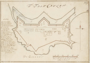
English: A Dutch map, titled ‘T' Fort Coylan’ represents situation of the fort in 1678, but the map was drafted after 1690, by Isaac de Graaf, for the Atlas Amsterdam. |
| Date | |
| Source | https://www.atlasofmutualheritage.nl/en/page/2549/maps-of-the-forts-at-cananor-cranganor-coylan-and-calicoilan |
| Author | Isaac de Graaf, for the Atlas Amsterdam |
Licensing[edit]
|
This work is in the public domain in its country of origin and other countries and areas where the copyright term is the author's life plus 70 years or fewer. This work is in the public domain in the United States because it was published (or registered with the U.S. Copyright Office) before January 1, 1929. | |
| This file has been identified as being free of known restrictions under copyright law, including all related and neighboring rights. | |
File history
Click on a date/time to view the file as it appeared at that time.
| Date/Time | Thumbnail | Dimensions | User | Comment | |
|---|---|---|---|---|---|
| current | 05:56, 9 August 2023 | | 301 × 213 (112 KB) | Akhilan (talk | contribs) | Uploaded a work by Isaac de Graaf, for the Atlas Amsterdam from https://www.atlasofmutualheritage.nl/en/page/2549/maps-of-the-forts-at-cananor-cranganor-coylan-and-calicoilan with UploadWizard |
You cannot overwrite this file.
File usage on Commons
There are no pages that use this file.