File:Koninkrijk.png
No ''Wikimedia Commons''
Pāriet uz navigāciju
Pāriet uz meklēšanu
Koninkrijk.png (480 × 440 pikseļi, faila izmērs: 11 KB, MIME tips: image/png)
Faila informācija
Strukturētie dati
Captions
Captions
Pievieno vienas rindiņas aprakstu, ko šis fails attēlo
Kopsavilkums[labot šo sadaļu]
| AprakstsKoninkrijk.png |
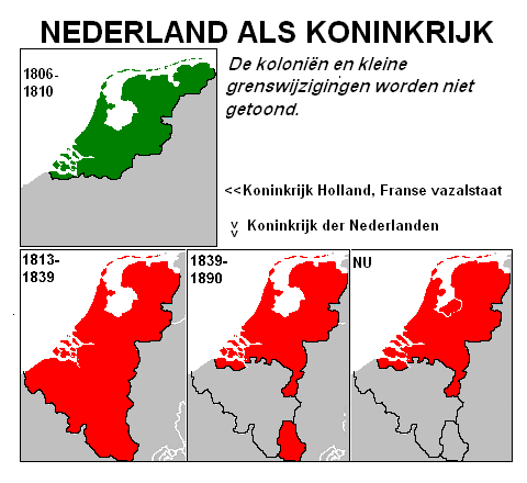
English: Comparison of the frontiers of the Kingdom of the Netherlands at various stages in history
Nederlands: Vergelijking van de grenzen van het Koninkrijk der Nederlanden in verschillende stadia van de geschiedenis |
| Datums | 2006. gada 30. decembris (upload date) |
| Avots | Paša darbs |
| Autors | User:Clockwork Orange |

|
This map has been uploaded by Electionworld from nl.wikipedia.org to enable the |
Licence[labot šo sadaļu]
| Public domainPublic domainfalsefalse |
| I, the copyright holder of this work, release this work into the public domain. This applies worldwide. In some countries this may not be legally possible; if so: I grant anyone the right to use this work for any purpose, without any conditions, unless such conditions are required by law. |
Faila hronoloģija
Uzklikšķini uz datums/laiks kolonnā esošās saites, lai apskatītos, kā šis fails izskatījās tad.
| Datums/Laiks | Attēls | Izmēri | Dalībnieks | Komentārs | |
|---|---|---|---|---|---|
| tagadējais | 2012. gada 18. decembris, plkst. 04.06 |  | 480 × 440 (11 KB) | Jahoe (diskusija | devums) | removed black image borders; cropped slightly larger; optimized png compression |
| 2006. gada 30. decembris, plkst. 15.10 |  | 471 × 418 (23 KB) | Electionworld (diskusija | devums) | {{ew|nl|Clockwork Orange}} == Beschrijving == Eigen kaart == Licentie == {{PD-eigen}} Category:Maps of the Netherlands |
Šo failu nevar pārrakstīt.
Faila lietojums
Šo failu izmanto šajā 1 lapā:
Globālais faila lietojums
Šīs Vikipēdijas izmanto šo failu:
- Izmantojums bar.wikipedia.org
- Izmantojums de.wikipedia.org
- Izmantojums la.wikipedia.org
- Izmantojums lv.wikipedia.org
