File:Konya districts.png
跳至導覽
跳至搜尋

預覽大小:737 × 599 像素。 其他解析度:295 × 240 像素 | 590 × 480 像素 | 958 × 779 像素。
原始檔案 (958 × 779 像素,檔案大小:56 KB,MIME 類型:image/png)
說明
說明
添加單行說明來描述出檔案所代表的內容
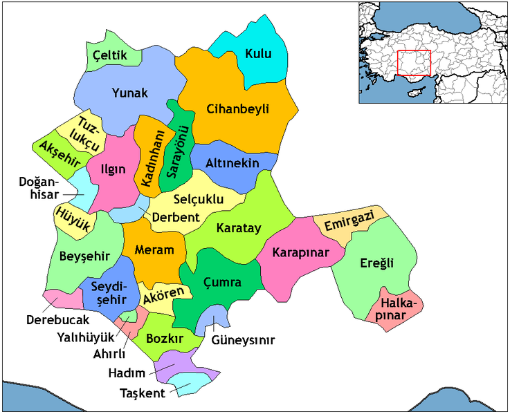
Konya Districts
摘要
[編輯]
Created by Rarelibra 22:01, 1 December 2006 (UTC) for public domain use, using MapInfo Professional v8.5 and various mapping resources. Edited by One Homo Sapiens Corrected text where İ,Ş,ı,ğ,or ş occurs in name. Source: [statoids-com]. Increased font size and enhanced color differences among adjacent districts.
| 描述 |
English: Map of the districts in the Province of Konya — in the Central Anatolia Region of Asian Turkey.
Svenska: Konya_Districts.png |
| 日期 | |
| 來源 | Created by Rarelibra, edited by One Homo Sapiens |
| 作者 | Rarelibra, One Homo Sapiens |
授權條款
[編輯]
| 我,此作品的版權所有人,釋出此作品至公共領域。此授權條款在全世界均適用。 這可能在某些國家不合法,如果是的話: 我授予任何人有權利使用此作品於任何用途,除受法律約束外,不受任何限制。 |
檔案歷史
點選日期/時間以檢視該時間的檔案版本。
| 日期/時間 | 縮圖 | 尺寸 | 使用者 | 備註 | |
|---|---|---|---|---|---|
| 目前 | 2014年10月29日 (三) 21:06 | | 958 × 779(56 KB) | Kimsaka(留言 | 貢獻) | white frame cropped |
| 2011年6月23日 (四) 10:14 |  | 1,056 × 816(55 KB) | Yrytyr(留言 | 貢獻) | Districts of Konya | |
| 2011年2月8日 (二) 19:00 |  | 730 × 600(222 KB) | Kurdische 1(留言 | 貢獻) | Districts Of Konya | |
| 2011年2月8日 (二) 18:50 |  | 730 × 600(220 KB) | Kurdische 1(留言 | 貢獻) | Districtrs Of Konya | |
| 2011年2月8日 (二) 18:08 |  | 800 × 600(270 KB) | Kurdische 1(留言 | 貢獻) | Districts Of Konya | |
| 2011年2月5日 (六) 14:43 |  | 712 × 583(221 KB) | Kurdische 1(留言 | 貢獻) | Districts_of_Konya.png | |
| 2011年2月5日 (六) 14:31 |  | 960 × 720(232 KB) | Kurdische 1(留言 | 貢獻) | Districts_of_Konya.png | |
| 2011年1月20日 (四) 18:03 |  | 800 × 600(162 KB) | Kurdische 1(留言 | 貢獻) | Konya_Turkey_Districts.png | |
| 2011年1月20日 (四) 17:46 |  | 1,056 × 816(46 KB) | Kurdische 1(留言 | 貢獻) | Reverted to version as of 22:01, 1 December 2006 | |
| 2008年12月29日 (一) 01:26 |  | 1,056 × 816(55 KB) | One Homo Sapiens(留言 | 貢獻) | Corrected text where İ,Ş,ı,ğ,or ş occurs in name. Source: [statoids-com]. Increased font size and enhanced color differences among adjacent districts. |
無法覆蓋此檔案。
檔案用途
下列5個頁面有用到此檔案:
全域檔案使用狀況
以下其他 wiki 使用了這個檔案:
- ar.wikipedia.org 的使用狀況
- ast.wikipedia.org 的使用狀況
- av.wikipedia.org 的使用狀況
- azb.wikipedia.org 的使用狀況
- ba.wikipedia.org 的使用狀況
- be.wikipedia.org 的使用狀況
- ca.wikipedia.org 的使用狀況
- ceb.wikipedia.org 的使用狀況
- ce.wikipedia.org 的使用狀況
- da.wikipedia.org 的使用狀況
- de.wikipedia.org 的使用狀況
- Konya
- Ereğli (Konya)
- Konya (Provinz)
- Diskussion:Konya
- Akşehir
- Beyşehir
- Doğanhisar
- Kulu (Konya)
- Cihanbeyli
- Vorlage:Navigationsleiste Landkreise der Provinz Konya
- Ahırlı
- Akören
- Altınekin
- Bozkır
- Çeltik
- Çumra
- Derbent (Konya)
- Derebucak
- Emirgazi
- Güneysınır
- Hadim (Konya)
- Halkapınar
- Hüyük
- Ilgın
- Kadınhanı
- Karatay (Konya)
- Meram (Konya)
- Sarayönü
- Selçuklu
- Seydişehir
- Taşkent
檢視此檔案的更多全域使用狀況。