File:Korean war 1950-1953.gif
Skočit na navigaci
Skočit na vyhledávání
Velikost tohoto náhledu: 387 × 600 pixelů. Jiná rozlišení: 155 × 240 pixelů | 562 × 871 pixelů.
Původní soubor (562 × 871 pixelů, velikost souboru: 1,32 MB, MIME typ: image/gif, ve smyčce, 20 snímků, 30 s)
Popisky
Popisky
Přidejte jednořádkové vysvětlení, co tento soubor představuje
It represents the land Korea gained

Popis[editovat]
| Popis |
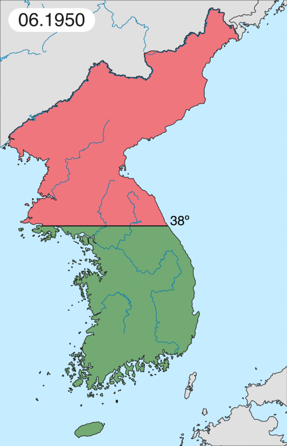
English: Map of Korean war from May 1950 to July 1951, showing:
Français : Carte de la guerre de Corée de mai 1950 à juillet 1951, montrant:
Deutsch: Karte des Koreakriegs von Mai 1950 bis Juli 1951, abgebildet:
Italiano: Mappa della guerra di Corea dal maggio 1950 al luglio 1951, rappresentante:
|
| Datum | |
| Zdroj | Vlastní dílo |
| Autor | Leomonaci98 |
Licence[editovat]
Já, držitel autorských práv k tomuto dílu, ho tímto zveřejňuji za podmínek následujících licencí:

|
Tento dokument smí být kopírován, šířen nebo upravován podle podmínek Svobodné licence GNU pro dokumenty verze 1.2 nebo libovolné vyšší verze publikované nadací Free Software Foundation. Dokument nemá neměnné části ani texty na předním či zadním přebalu. Kopie textu licence je k dispozici v oddíle nazvaném GNU Free Documentation License. |
| Tento soubor podléhá licenci Creative Commons Uveďte autora-Zachovejte licenci 3.0 Unported | ||
| ||
| Tato licenční šablona byla k tomuto souboru přidána v rámci změny licencování. |
Můžete si zvolit libovolnou z těchto licencí.
Historie souboru
Kliknutím na datum a čas se zobrazí tehdejší verze souboru.
| Datum a čas | Náhled | Rozměry | Uživatel | Komentář | |
|---|---|---|---|---|---|
| současná | 16. 2. 2020, 20:20 | | 562 × 871 (1,32 MB) | Leomonaci98 (diskuse | příspěvky) | Graphic update |
| 1. 5. 2013, 01:02 |  | 227 × 400 (85 KB) | Spesh531 (diskuse | příspěvky) | update for every month | |
| 9. 6. 2006, 08:47 |  | 227 × 400 (37 KB) | Roke~commonswiki (diskuse | příspěvky) | rm white | |
| 8. 6. 2006, 06:25 |  | 227 × 400 (37 KB) | Roke~commonswiki (diskuse | příspěvky) | add OngJin peninsula after comment, also blank frame at end | |
| 5. 6. 2006, 15:14 |  | 227 × 400 (37 KB) | Roke~commonswiki (diskuse | příspěvky) | Korean war, showing North Korean, Chinese and communist forces (red); South Korean, US and United Nations forces (green). Category: Korean War Category: Animated maps |
Tento soubor nemůžete přepsat.
Využití souboru
Na Commons na soubor odkazují tyto stránky:
Globální využití souboru
Tento soubor využívají následující wiki:
- Využití na af.wikipedia.org
- Využití na az.wikipedia.org
- Využití na bat-smg.wikipedia.org
- Využití na bg.wikipedia.org
- Využití na br.wikipedia.org
- Využití na bs.wikipedia.org
- Využití na ca.wikipedia.org
- Corea del Nord
- Corea del Sud
- Ióssif Stalin
- Mao Zedong
- Winston Churchill
- Harry Truman
- Guerra de Corea
- Kim Il-sung
- Viatxeslav Mólotov
- Gueorgui Malenkov
- Douglas MacArthur
- Lavrenti Béria
- M*A*S*H (pel·lícula)
- Clement Attlee
- Mark Wayne Clark
- Zona desmilitaritzada de Corea
- República Popular d'Hongria
- Syngman Rhee
- Peng Dehuai
- Força Aèria de l'Exèrcit Popular de Corea
- Forces Armades de Corea del Nord
- Forces Armades de la República de Corea
- 65è Regiment d'Infanteria (Estats Units)
- Frontera entre Corea del Nord i Corea del Sud
- Kim Chaek
- Batalla d'Inchon
- Plantilla:Guerra de Corea
- Pak Hon-yong
- Využití na ckb.wikipedia.org
- Využití na cs.wikipedia.org
- Využití na cy.wikipedia.org
- Využití na da.wikipedia.org
- Využití na de.wikipedia.org
- Využití na el.wikipedia.org
- Využití na en.wikipedia.org
Zobrazit další globální využití tohoto souboru.