File:Korean war 1950-1953.gif
Przejdź do nawigacji
Przejdź do wyszukiwania
Rozmiar podglądu – 387 × 600 pikseli. Inne rozdzielczości: 155 × 240 pikseli | 562 × 871 pikseli.
Rozmiar pierwotny (562 × 871 pikseli, rozmiar pliku: 1,32 MB, typ MIME: image/gif, zapętlony, 20 klatek, 30 s)
Podpisy
Podpisy
Dodaj jednolinijkowe objaśnienie tego, co ten plik pokazuje
It represents the land Korea gained
Opis[edytuj]
| Opis |
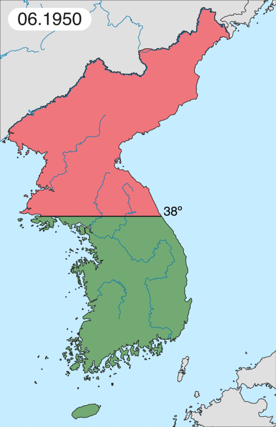
English: Map of Korean war from May 1950 to July 1951, showing:
Français : Carte de la guerre de Corée de mai 1950 à juillet 1951, montrant:
Deutsch: Karte des Koreakriegs von Mai 1950 bis Juli 1951, abgebildet:
Italiano: Mappa della guerra di Corea dal maggio 1950 al luglio 1951, rappresentante:
|
| Data | |
| Źródło | Praca własna |
| Autor | Leomonaci98 |
Licencja[edytuj]
Ja, właściciel praw autorskich do tego dzieła, udostępniam je na poniższych licencjach

|
Udziela się zgody na kopiowanie, rozpowszechnianie oraz modyfikowanie tego dokumentu zgodnie z warunkami GNU Licencji Wolnej Dokumentacji, w wersji 1.2 lub nowszej opublikowanej przez Free Software Foundation; bez niezmiennych sekcji, bez treści umieszczonych na frontowej lub tylnej stronie okładki. Kopia licencji załączona jest w sekcji zatytułowanej GNU Licencja Wolnej Dokumentacji. |
| Ten plik udostępniony jest na licencji Creative Commons Uznanie autorstwa – Na tych samych warunkach 3.0. | ||
| ||
| Ten szablon został dodany jako element zmiany licencjonowania. |
Możesz wybrać, którą licencję chcesz zastosować.
Historia pliku
Kliknij na odpowiedniej dacie/czasie, aby zobaczyć wersję pliku z tamtego okresu.
| Data/czas | Miniatura | Wymiary | Użytkownik | Opis | |
|---|---|---|---|---|---|
| aktualny | 20:20, 16 lut 2020 | | 562 × 871 (1,32 MB) | Leomonaci98 (dyskusja | edycje) | Graphic update |
| 01:02, 1 maj 2013 |  | 227 × 400 (85 KB) | Spesh531 (dyskusja | edycje) | update for every month | |
| 08:47, 9 cze 2006 |  | 227 × 400 (37 KB) | Roke~commonswiki (dyskusja | edycje) | rm white | |
| 06:25, 8 cze 2006 |  | 227 × 400 (37 KB) | Roke~commonswiki (dyskusja | edycje) | add OngJin peninsula after comment, also blank frame at end | |
| 15:14, 5 cze 2006 |  | 227 × 400 (37 KB) | Roke~commonswiki (dyskusja | edycje) | Korean war, showing North Korean, Chinese and communist forces (red); South Korean, US and United Nations forces (green). Category: Korean War Category: Animated maps |
Nie możesz nadpisać tego pliku.
Lokalne wykorzystanie pliku
Następujące strony korzystają z tego pliku:
Globalne wykorzystanie pliku
Ten plik jest wykorzystywany także w innych projektach wiki:
- Wykorzystanie na af.wikipedia.org
- Wykorzystanie na az.wikipedia.org
- Wykorzystanie na bat-smg.wikipedia.org
- Wykorzystanie na bg.wikipedia.org
- Wykorzystanie na br.wikipedia.org
- Wykorzystanie na bs.wikipedia.org
- Wykorzystanie na ca.wikipedia.org
- Corea del Nord
- Corea del Sud
- Ióssif Stalin
- Mao Zedong
- Winston Churchill
- Harry Truman
- Guerra de Corea
- Kim Il-sung
- Viatxeslav Mólotov
- Gueorgui Malenkov
- Douglas MacArthur
- Lavrenti Béria
- M*A*S*H (pel·lícula)
- Clement Attlee
- Mark Wayne Clark
- Zona desmilitaritzada de Corea
- República Popular d'Hongria
- Syngman Rhee
- Peng Dehuai
- Força Aèria de l'Exèrcit Popular de Corea
- Forces Armades de Corea del Nord
- Forces Armades de la República de Corea
- 65è Regiment d'Infanteria (Estats Units)
- Frontera entre Corea del Nord i Corea del Sud
- Kim Chaek
- Batalla d'Inchon
- Plantilla:Guerra de Corea
- Pak Hon-yong
- Wykorzystanie na ckb.wikipedia.org
- Wykorzystanie na cs.wikipedia.org
- Wykorzystanie na cy.wikipedia.org
- Wykorzystanie na da.wikipedia.org
- Wykorzystanie na de.wikipedia.org
- Wykorzystanie na el.wikipedia.org
- Wykorzystanie na en.wikipedia.org
Pokaż listę globalnego wykorzystania tego pliku.