File:Koundian.jpg
Jump to navigation
Jump to search

Size of this preview: 800 × 440 pixels. Other resolutions: 320 × 176 pixels | 640 × 352 pixels | 1,200 × 660 pixels.
Original file (1,200 × 660 pixels, file size: 160 KB, MIME type: image/jpeg)
Captions
Captions
Add a one-line explanation of what this file represents
Summary
[edit]
| Camera location | | View this and other nearby images on: OpenStreetMap |
|---|
| Description |
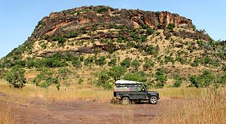
English: Koundian, Kayes Region, Mali |
|||
| Date | ||||
| Source | Originally uploaded to Flickr | |||
| Author | Jacques Taberlet | |||
| Permission (Reusing this file) |
|
|||
Licensing
[edit]
This file is licensed under the Creative Commons Attribution 3.0 Unported license.
- You are free:
- to share – to copy, distribute and transmit the work
- to remix – to adapt the work
- Under the following conditions:
- attribution – You must give appropriate credit, provide a link to the license, and indicate if changes were made. You may do so in any reasonable manner, but not in any way that suggests the licensor endorses you or your use.
File history
Click on a date/time to view the file as it appeared at that time.
| Date/Time | Thumbnail | Dimensions | User | Comment | |
|---|---|---|---|---|---|
| current | 22:32, 8 February 2009 | | 1,200 × 660 (160 KB) | Dr. Blofeld~commonswiki (talk | contribs) | {{Information |Description={{en|1=d}} |Source=d |Author=d |Date=d |Permission= |other_versions= }} <!--{{ImageUpload|full}}--> |
You cannot overwrite this file.
File usage on Commons
There are no pages that use this file.
File usage on other wikis
The following other wikis use this file:
- Usage on en.wikipedia.org
- Usage on fi.wikipedia.org
- Usage on fr.wikipedia.org
- Usage on nl.wikipedia.org
- Usage on www.wikidata.org
- Usage on zh-min-nan.wikipedia.org