File:Kouri Island gsi-20180219.jpg
跳至導覽
跳至搜尋

預覽大小:600 × 600 像素。 其他解析度:240 × 240 像素 | 480 × 480 像素 | 768 × 768 像素 | 1,024 × 1,024 像素 | 2,048 × 2,048 像素 | 5,000 × 5,000 像素。
原始檔案 (5,000 × 5,000 像素,檔案大小:6.67 MB,MIME 類型:image/jpeg)
說明
說明
添加單行說明來描述出檔案所代表的內容
摘要
[編輯]| 描述 |
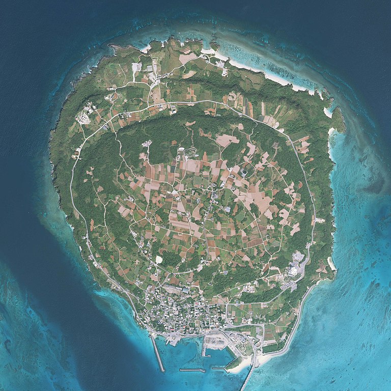
English: Kouri Island, Nakijin, Okinawa Prefecture, Japan. Combined 10 aerial photos taken by Geospatial Information Authority of Japan.
日本語: 古宇利島
国土交通省の地図・空中写真閲覧サービスを元に作成。10枚の航空写真を使用。
|
| 日期 | 攝於2018年2月19日 |
| 來源 | COK20172-C1-2, C1-3, C1-4, C1-5, C1-6, C2-3, C2-4, C2-5, C2-6, C2-7 |
| 作者 |
English: Geospatial Information Authority of Japan
日本語: 国土地理院 |
| 拍攝地點 | | 位於此地的本圖片與其他圖片: OpenStreetMap |
|---|
| 這是一張修飾過的圖片,即本圖片是用軟體修改過後的版本,修改的方式或內容有:Combined 10 aerial photos and cropped。修改者:Kugel~commonswiki。
|

|
注意:这是一张全景图,使用软件将10张图片拼接而成。所以该图片经过了某些数字化的操作。这些操作可能包括混合,模糊,克隆,以及颜色和角度的调整。由于这些调整,图片在接缝处可能和真实照片有一些差异。这些操作往往会带来镜头,透视和视差方面的失真。
|
授權條款
[編輯]
|
本檔案的著作權持有者,Ministry of Land, Infrastructure, Transport and Tourism,在註明所有人姓名的前提下,允許任何人使用本檔案於任何用途。包含再散布、衍生作品、商業用途及其他用途。 |
姓名標示:
National Land Image Information (Color Aerial Photographs), created by Ministry of Land, Infrastructure, Transport and Tourism, distributed by Geospatial Information Authority of Japan
|

檔案歷史
點選日期/時間以檢視該時間的檔案版本。
| 日期/時間 | 縮圖 | 尺寸 | 使用者 | 備註 | |
|---|---|---|---|---|---|
| 目前 | 2018年6月19日 (二) 06:16 | | 5,000 × 5,000(6.67 MB) | Kugel~commonswiki(留言 | 貢獻) | {{Information |Description={{en|1=Kouri Island, Nakijin, Okinawa Prefecture, Japan. Combined 10 aerial photos taken by Geospatial Information Authority of Japan. *Reference Number : COK20172 *Location : Nago *Course and Photo Number : C1-2~6, C2-3~7 *Date taken : 19 February 2018 }} {{ja|1=古宇利島 国土交通省の地図・空中写真閲覧サービスを元に作成。10枚の航空写真を使用。 * 整理番号 : COK20172 * 撮影地域 : 名護 * コース - 写真番号 : C1-2からC1-6, C2-3からC2-7 * 撮影年月日 : 2018年2月19日 }} |Source=[http://mapps.gsi.go.jp/contentsImageDisplay.do?specificationId... |
無法覆蓋此檔案。
檔案用途
下列3個頁面有用到此檔案:
全域檔案使用狀況
以下其他 wiki 使用了這個檔案:
- ceb.wikipedia.org 的使用狀況
- ja.wikipedia.org 的使用狀況
- www.wikidata.org 的使用狀況
- zh.wikipedia.org 的使用狀況