File:Krimpen IJssel 1867.gif
跳至導覽
跳至搜尋

預覽大小:700 × 600 像素。 其他解析度:280 × 240 像素 | 560 × 480 像素 | 896 × 768 像素 | 1,195 × 1,024 像素 | 1,600 × 1,371 像素。
原始檔案 (1,600 × 1,371 像素,檔案大小:174 KB,MIME 類型:image/gif)
說明
說明
添加單行說明來描述出檔案所代表的內容
摘要
[編輯]
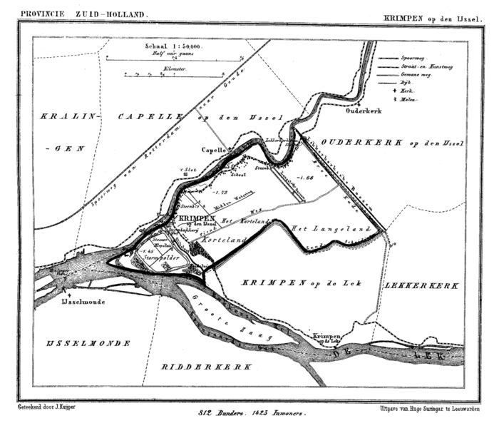
| 描述 | Historic map of Krimpen aan den IJssel, the Netherlands |
| 日期 | 在1865年到1870年之間 |
| 來源 | Gemeente Atlas van Nederland (Municipal Atlas of the Netherlands) |
| 作者 | J. Kuyper |
授權條款
[編輯]
|
本作品在其來源國以及其他著作權期限是作者逝世後70年或以下的國家與地區屬於公有領域。
| |
| 此作品無已知的著作權限制,亦不受所有相關和鄰接的權利限制。 | |
檔案歷史
點選日期/時間以檢視該時間的檔案版本。
| 日期/時間 | 縮圖 | 尺寸 | 使用者 | 備註 | |
|---|---|---|---|---|---|
| 目前 | 2007年3月15日 (四) 17:31 | | 1,600 × 1,371(174 KB) | P199(留言 | 貢獻) | {{Information |Description=Historic map of Krimpen aan den IJssel, the Netherlands |Source=Gemeente Atlas van Nederland (Municipal Atlas of the Netherlands) |Date=1865-1870 |Author=J. Kuyper |Permission= |other_versions= }} [[Category:Gemeente Atlas van |
| 2007年3月15日 (四) 17:25 |  | 1,600 × 1,371(175 KB) | P199(留言 | 貢獻) | {{Information |Description=Historic map of Krimpen aan den IJssel, the Netherlands |Source=Gemeente Atlas van Nederland (Municipal Atlas of the Netherlands) |Date=1865-1870 |Author=J. Kuyper |Permission= |other_versions= }} [[Category:Gemeente Atlas van |
無法覆蓋此檔案。
檔案用途
下列頁面有用到此檔案:
全域檔案使用狀況
以下其他 wiki 使用了這個檔案:
- de.wikipedia.org 的使用狀況
- en.wikipedia.org 的使用狀況
- fa.wikipedia.org 的使用狀況
- fi.wikipedia.org 的使用狀況
- fr.wikipedia.org 的使用狀況
- id.wikipedia.org 的使用狀況
- vi.wikipedia.org 的使用狀況
- zh.wikipedia.org 的使用狀況