File:Kukenan Roraima GS.jpg

原始檔案 (4,851 × 1,533 像素,檔案大小:3.64 MB,MIME 類型:image/jpeg)
說明
說明
摘要
[編輯]
| 描述 |
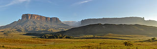
English: Morning view of Kukenan and Roraima tepuis, from Tëk river camp (river visible in the image), in Gran Sabana, Venezuela. Roraima tepui is actually some 100 mts higher than Kukenan, but due to the perspective of the picture, it looks like it is lower.
Español: Vista matutina de los tepuys Kukenan y Roraima, desde el campamente del río Tëk (con el río visible en la imagen), en la Gran Sabana, Venezuela. El tepuy Roraima es en realidad unos cien metros más alto que el Kukenan, aunque por la perspectiva de la foto, parece lo contrario.
Français : Vue matinale sur le Tepuy Kukenan et le Mont Roraima, depuis le camp de la rivière Tëk, dans la Gran Sabana (Vénézuela). Le Roraima Fait 100 m de plus que le Kukenan, bien qu'il apparaisse moins haut sur l'image, à cause de la perspective.
Bosanski: Jutarnja panorama Kukenana i tepui planine Roraima, iz riječnog kampa Tëk, Gran Sabana, Venecuela.
Italiano: Panorama al mattino dei tepui di Kukenan e Roraima dal campo sul fiume Tëk, Gran Sabana in Venezuela.
|
|||
| 日期 | ||||
| 來源 | 自己的作品 | |||
| 作者 | Paolo Costa Baldi | |||
| 授權許可 (重用此檔案) |
|
| 拍攝地點 | | 位於此地的本圖片與其他圖片: OpenStreetMap |
|---|
|
This image was selected as picture of the day on Wikimedia Commons for 10 July 2015. It was captioned as follows: Other languages:
Bosanski: Jutarnja panorama Kukenana i tepui planine Roraima, iz riječnog kampa Tëk, Gran Sabana, Venecuela. Español: Vista matutina de los tepuys Kukenan y Roraima, desde el campamente del río Tëk (con el río visible en la imagen), en la Gran Sabana, Venezuela. Italiano: Panorama al mattino dei tepui di Kukenan e Roraima dal campo sul fiume Tëk, Gran Sabana in Venezuela. |
授權條款
[編輯]
- 您可以自由:
- 分享 – 複製、發佈和傳播本作品
- 重新修改 – 創作演繹作品
- 惟需遵照下列條件:
- 姓名標示 – 您必須指名出正確的製作者,和提供授權條款的連結,以及表示是否有對內容上做出變更。您可以用任何合理的方式來行動,但不得以任何方式表明授權條款是對您許可或是由您所使用。
- 相同方式分享 – 如果您利用本素材進行再混合、轉換或創作,您必須基於如同原先的相同或兼容的條款,來分布您的貢獻成品。

|
已授權您依據自由軟體基金會發行的無固定段落、封面文字和封底文字GNU自由文件授權條款1.2版或任意後續版本,對本檔進行複製、傳播和/或修改。該協議的副本列在GNU自由文件授權條款中。 |
| 註解 | 該圖片含有註解:在維基媒體共享資源上查看註解 |
檔案歷史
點選日期/時間以檢視該時間的檔案版本。
| 日期/時間 | 縮圖 | 尺寸 | 用戶 | 備註 | |
|---|---|---|---|---|---|
| 目前 | 2011年10月20日 (四) 03:42 | 4,851 × 1,533(3.64 MB) | Paolostefano1412(對話 | 貢獻) | {{Information |Description ={{en|1=Morning view of Kukenan and Roraima tepuis, from River Tëk camp (river visible in the image).}} {{es|1=Vista matutina de los tepuys Kukenan y Roraima, desde el campamente del río Tëk (con el río visible en la imag |
無法覆蓋此檔案。
檔案用途
下列39個頁面有用到此檔案:
- Venezuela
- User:Biyergeyiyer
- User:Paolostefano1412
- User:Rodrigo.Argenton/test
- User:Stratokumulus/Favorites
- User:Tomer T
- User:Ö/Best/2012
- User talk:Tomer T/Archive 1
- Commons:Featured picture candidates/File:Kukenan Roraima GS.jpg
- Commons:Featured picture candidates/Log/January 2012
- Commons:Featured pictures/Places/Natural
- Commons:Featured pictures/Places/Panoramas
- Commons:Featured pictures/chronological/2012-A
- Commons:Photo challenge/2015 - May - Panoramas
- Commons:Picture of the Year/2012/Galleries/2012-A
- Commons:Picture of the Year/2012/Galleries/ALL
- Commons:Picture of the Year/2012/Galleries/Index/1
- Commons:Picture of the Year/2012/Galleries/JAN
- Commons:Picture of the Year/2012/Galleries/Panoramic views
- Commons:Picture of the Year/2012/R1/Kukenan Roraima GS.jpg
- Commons:Picture of the Year/2012/Results/R1/ALL
- Commons:Picture of the Year/2012/Results/R1/ALL/gallery
- Commons:Picture of the Year/2012/Results/R1/ALL/thumbnailtable
- Commons:Picture of the Year/2012/Results/R1/Panoramic views
- Commons:Wiki Loves Earth 2024 in Brazil
- Commons talk:Photo challenge/themes/Archive
- Template:Potd/2015-07
- Template:Potd/2015-07-10
- Template:Potd/2015-07-10 (bs)
- Template:Potd/2015-07-10 (cs)
- Template:Potd/2015-07-10 (en)
- Template:Potd/2015-07-10 (es)
- Template:Potd/2015-07-10 (hu)
- Template:Potd/2015-07-10 (it)
- Template:Potd/2015-07-10 (ko)
- Template:Potd/2015-07-10 (nl)
- Template:Potd/2015-07-10 (pt)
- Template:Potd/2015-07-10 (uk)
- Category:La Gran Sabana
全域檔案使用狀況
以下其他 wiki 使用了這個檔案:
- ast.wikipedia.org 的使用狀況
- av.wikipedia.org 的使用狀況
- az.wikipedia.org 的使用狀況
- be-tarask.wikipedia.org 的使用狀況
- bn.wikipedia.org 的使用狀況
- bs.wikipedia.org 的使用狀況
- crh.wikipedia.org 的使用狀況
- cs.wikipedia.org 的使用狀況
- cv.wikipedia.org 的使用狀況
- cy.wikipedia.org 的使用狀況
- da.wikipedia.org 的使用狀況
- de.wikipedia.org 的使用狀況
- en.wikipedia.org 的使用狀況
- Wikipedia:WikiProject Protected areas
- Gran Sabana
- Portal:Venezuela
- Wikipedia:Featured pictures/Places/Panorama
- Talk:Gran Sabana
- User talk:Paolostefano1412
- Wikipedia:WikiProject Geology/Recognized content
- Wikipedia:Featured pictures thumbs/33
- Wikipedia:Featured picture candidates/January-2013
- User talk:Razr Nation/2013/2
- Wikipedia:Featured picture candidates/Kukenan Roraima GS
- User:Razr Nation/FPs
- Distribution of Heliamphora
- Eastern Tepuis
- Wikipedia:Picture of the day/May 2014
- User talk:Razr Nation/2014/4
- Template:POTD/2014-05-29
- Wikipedia:Main Page history/2014 May 29
- Wikipedia:WikiProject Geology/Automated list of recognized content
- Raleigh's El Dorado expedition
- Portal:Venezuela/Recognized content
- en.wikivoyage.org 的使用狀況
- es.wikipedia.org 的使用狀況
- La Gran Sabana
- Anexo:Patrimonio de la Humanidad en América Latina y el Caribe
- Wikipedia:Imágenes destacadas/Lugares/Sudamérica
- Wikipedia:Recurso del día/501 - 600
- Wikipedia:Candidatos a recursos destacados/Diciembre-2011
- Wikipedia:Candidatos a recursos destacados/Kukenan Roraima GS.jpg
- Plantilla:RDD/556
- Wikipedia:Recurso del día/enero de 2012
- Wikipedia:Recurso del día/febrero de 2013
- Usuario discusión:Eduardosalg/Archivo57/Archivo56/Archivo39
- Usuario:JosueCarrion
- Usuario:Eduardosalg/Vitrina
- Usuario:Leanex77
檢視此檔案的更多全域使用狀況。