File:Kumamoto sports park.jpg
From Wikimedia Commons, the free media repository
Jump to navigation
Jump to search
![File:Kumamoto sports park.jpg](https://upload.wikimedia.org/wikipedia/commons/thumb/7/74/Kumamoto_sports_park.jpg/800px-Kumamoto_sports_park.jpg?20110329164144)
Size of this preview: 800 × 454 pixels. Other resolutions: 320 × 181 pixels | 640 × 363 pixels | 1,024 × 581 pixels | 1,280 × 726 pixels | 2,000 × 1,134 pixels.
Original file (2,000 × 1,134 pixels, file size: 364 KB, MIME type: image/jpeg)
File information
Structured data
Captions
Captions
Add a one-line explanation of what this file represents
Summary
[edit]DescriptionKumamoto sports park.jpg |
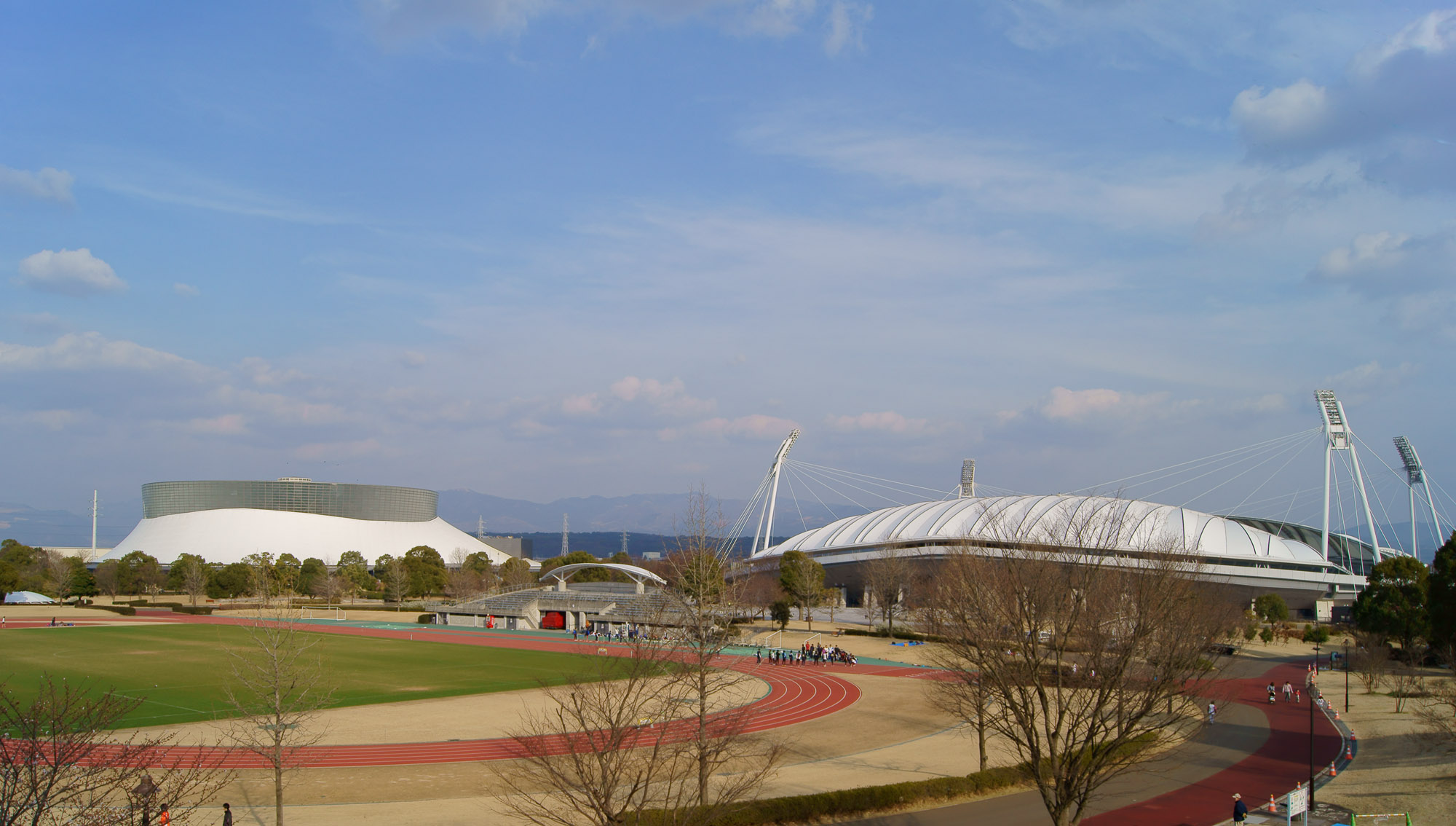
English: (right to left) Main stadium aka KKWING, supplemental track, the Park Dome of Kumamoto prefectural sports park, Japan.
日本語: 熊本県民総合運動公園。右からKKWING、補助競技場、パークドーム熊本。 |
Date | |
Source | Own work |
Author | Motoki-jj |
Camera location | 32° 50′ 19.01″ N, 130° 47′ 47.91″ E ![]() | View this and other nearby images on: OpenStreetMap | ![]() |
---|
Licensing
[edit]I, the copyright holder of this work, hereby publish it under the following license:
![w:en:Creative Commons](https://upload.wikimedia.org/wikipedia/commons/thumb/7/79/CC_some_rights_reserved.svg/90px-CC_some_rights_reserved.svg.png)
![attribution](https://upload.wikimedia.org/wikipedia/commons/thumb/1/11/Cc-by_new_white.svg/24px-Cc-by_new_white.svg.png)
![share alike](https://upload.wikimedia.org/wikipedia/commons/thumb/d/df/Cc-sa_white.svg/24px-Cc-sa_white.svg.png)
This file is licensed under the Creative Commons Attribution-Share Alike 3.0 Unported license.
- You are free:
- to share – to copy, distribute and transmit the work
- to remix – to adapt the work
- Under the following conditions:
- attribution – You must give appropriate credit, provide a link to the license, and indicate if changes were made. You may do so in any reasonable manner, but not in any way that suggests the licensor endorses you or your use.
- share alike – If you remix, transform, or build upon the material, you must distribute your contributions under the same or compatible license as the original.
File history
Click on a date/time to view the file as it appeared at that time.
Date/Time | Thumbnail | Dimensions | User | Comment | |
---|---|---|---|---|---|
current | 16:41, 29 March 2011 | ![]() | 2,000 × 1,134 (364 KB) | Motoki-jj (talk | contribs) | == {{int:filedesc}} == {{Information |Description={{en|(right to left) Main stadium aka KKWING, supplemental track, the Park Dome of Kumamoto prefectural sports park, Japan.}} {{ja|熊本県民総合運動公園。右からKKWING、補助競技場スタ� |
05:54, 30 December 2007 | ![]() | 1,536 × 1,152 (160 KB) | K.F. (talk | contribs) | {{Information |Description={{en|(right to left) Main stadium aka KKWING, supplemental track, the Park Dome of Kumamoto prefectural sports park, Japan.}} {{ja|熊本県民総合運動公園。右からKKWING、補助競技場スタンド、パークドー� |
You cannot overwrite this file.
File usage on Commons
There are no pages that use this file.
File usage on other wikis
The following other wikis use this file:
- Usage on en.wikipedia.org
- Usage on ja.wikipedia.org
Metadata
This file contains additional information such as Exif metadata which may have been added by the digital camera, scanner, or software program used to create or digitize it. If the file has been modified from its original state, some details such as the timestamp may not fully reflect those of the original file. The timestamp is only as accurate as the clock in the camera, and it may be completely wrong.
Image title |
|
---|---|
Camera manufacturer | SONY |
Camera model | SLT-A55V |
Exposure time | 1/160 sec (0.00625) |
F-number | f/11 |
ISO speed rating | 100 |
Date and time of data generation | 17:38, 26 March 2011 |
Lens focal length | 18 mm |
Latitude | 32° 50′ 19.01″ N |
Longitude | 130° 47′ 47.92″ E |
Altitude | 103.7 meters above sea level |
Width | 4,912 px |
Height | 3,264 px |
Bits per component |
|
Compression scheme | Uncompressed |
Pixel composition | RGB |
Orientation | Normal |
Number of components | 3 |
Horizontal resolution | 350 dpi |
Vertical resolution | 350 dpi |
Data arrangement | chunky format |
Software used | Adobe Photoshop CS4 Windows |
File change date and time | 01:34, 30 March 2011 |
Exposure Program | Normal program |
Exif version | 2.21 |
Date and time of digitizing | 17:38, 26 March 2011 |
APEX brightness | 9.37 |
APEX exposure bias | 0 |
Maximum land aperture | 3.61 APEX (f/3.49) |
Metering mode | Pattern |
Light source | Unknown |
Flash | Flash did not fire, compulsory flash suppression |
Supported Flashpix version | 1 |
Color space | sRGB |
Custom image processing | Normal process |
Exposure mode | Auto exposure |
White balance | Auto white balance |
Focal length in 35 mm film | 27 mm |
Scene capture type | Standard |
Contrast | Normal |
Saturation | Normal |
Sharpness | Normal |
GPS time (atomic clock) | 07:38:31.847 |
Receiver status | Measurement in progress |
Measurement mode | 3-dimensional measurement |
Speed unit | Kilometers per hour |
Speed of GPS receiver | 1.8 |
Reference for direction of movement | True direction |
Direction of movement | 106.44 |
Geodetic survey data used | WGS-84 |
GPS date | 26 March 2011 |
GPS differential correction | 0 |
GPS tag version | 0.0.3.2 |
Supported Flashpix version | 1 |
Image width | 2,000 px |
Image height | 1,134 px |
Date metadata was last modified | 10:34, 30 March 2011 |
Unique ID of original document | xmp.did:B1AF77F31C5AE0119725DF6ADE7309C3 |
IIM version | 36 |