File:Kutch Basin geology and Vasuki locality.png
Jump to navigation
Jump to search

Size of this preview: 800 × 248 pixels. Other resolutions: 320 × 99 pixels | 640 × 198 pixels | 1,984 × 614 pixels.
Original file (1,984 × 614 pixels, file size: 1.1 MB, MIME type: image/png)
Captions
Captions
Add a one-line explanation of what this file represents
Summary[edit]
| Description |
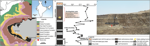
English: Geological map of Kutch Basin showing fossil locality (a); stratigraphic column at Panandhro Lignite Mine showing the position of madtsoiid snake-yielding horizon with age diagnostic dinoflagellate cyst assemblage and δ13C curve marking hyperthermal event ETM2 (modified after Agrawal et al.23) (b); panoramic view of the fossil site (c). Map and stratigraphic column were drawn by D.D. using CorelDRAW 2019. ETM2 age estimate after Westerhold et al.24. |
| Date | |
| Source | "Largest known madtsoiid snake from warm Eocene period of India suggests intercontinental Gondwana dispersal" |
| Author | D. Datta & S. Bajpai |
Licensing[edit]
This file is licensed under the Creative Commons Attribution 4.0 International license.
- You are free:
- to share – to copy, distribute and transmit the work
- to remix – to adapt the work
- Under the following conditions:
- attribution – You must give appropriate credit, provide a link to the license, and indicate if changes were made. You may do so in any reasonable manner, but not in any way that suggests the licensor endorses you or your use.
File history
Click on a date/time to view the file as it appeared at that time.
| Date/Time | Thumbnail | Dimensions | User | Comment | |
|---|---|---|---|---|---|
| current | 03:30, 19 April 2024 | 1,984 × 614 (1.1 MB) | SlvrHwk (talk | contribs) | Uploaded a work by D. Datta & S. Bajpai from [https://doi.org/10.1038%2Fs41598-024-58377-0 "Largest known madtsoiid snake from warm Eocene period of India suggests intercontinental Gondwana dispersal"] with UploadWizard |
You cannot overwrite this file.
File usage on Commons
There are no pages that use this file.
File usage on other wikis
The following other wikis use this file:
- Usage on de.wikipedia.org