File:Kymijoki drainage basin map.svg
Jump to navigation
Jump to search

Size of this PNG preview of this SVG file: 334 × 599 pixels. Other resolutions: 134 × 240 pixels | 267 × 480 pixels | 428 × 768 pixels | 571 × 1,024 pixels | 1,142 × 2,048 pixels | 948 × 1,700 pixels.
Original file (SVG file, nominally 948 × 1,700 pixels, file size: 16.64 MB)
Captions
Captions
Add a one-line explanation of what this file represents
Summary[edit]
| Description |
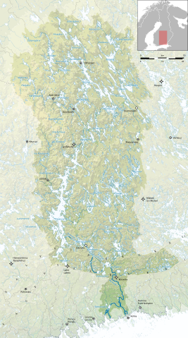
English: Topographic map of the Kymi river basin.
Suomi: Topografinen kartta Kymijoen vesistöalueesta.
Svenska: Topografisk karta av Kymmene älvs avrinningsområde. |
| Source |
Own work
|
| Author | Nelg |
| SVG development | This oversized W3C-invalid Natural Earth map was created with Adobe Illustrator, and with Inkscape. |
Licensing[edit]
I, the copyright holder of this work, hereby publish it under the following licenses:

|
Permission is granted to copy, distribute and/or modify this document under the terms of the GNU Free Documentation License, Version 1.2 or any later version published by the Free Software Foundation; with no Invariant Sections, no Front-Cover Texts, and no Back-Cover Texts. A copy of the license is included in the section entitled GNU Free Documentation License. |
This file is licensed under the Creative Commons Attribution 4.0 International license.
- You are free:
- to share – to copy, distribute and transmit the work
- to remix – to adapt the work
- Under the following conditions:
- attribution – You must give appropriate credit, provide a link to the license, and indicate if changes were made. You may do so in any reasonable manner, but not in any way that suggests the licensor endorses you or your use.
You may select the license of your choice.
File history
Click on a date/time to view the file as it appeared at that time.
| Date/Time | Thumbnail | Dimensions | User | Comment | |
|---|---|---|---|---|---|
| current | 16:11, 9 April 2020 | | 948 × 1,700 (16.64 MB) | Nelg (talk | contribs) | Yet another attempt |
| 14:16, 9 April 2020 |  | 948 × 1,700 (13.06 MB) | Nelg (talk | contribs) | Hillshade traced | |
| 12:31, 14 October 2019 |  | 1,264 × 2,267 (35.93 MB) | Nelg (talk | contribs) | Another attempt | |
| 12:22, 14 October 2019 |  | 1,264 × 2,267 (35.86 MB) | Nelg (talk | contribs) | Another fix | |
| 12:09, 14 October 2019 |  | 1,264 × 2,267 (35.86 MB) | Nelg (talk | contribs) | SVG fix | |
| 12:00, 14 October 2019 |  | 1,264 × 2,267 (32.96 MB) | Nelg (talk | contribs) | Reupload | |
| 11:49, 14 October 2019 |  | 1,264 × 2,267 (32.95 MB) | Nelg (talk | contribs) | {{Information |description ={{en|1=Topographic map of the Kymi river basin.}} {{fi|1=Topografinen kartta Kymijoen vesistöalueesta.}} {{sv|1=Topografisk karta av Kymmene älvs avrinningsområde.}} |date = |source ={{own}} * Topography: [http://www.maanmittauslaitos.fi/en/maps-and-spatial-data/expert-users/product-descriptions/elevation-model-2-m Elevation model 2 m] / National Land Survey of Finland (open data, CC BY 4.0... |
You cannot overwrite this file.
File usage on Commons
The following 2 pages use this file:
File usage on other wikis
The following other wikis use this file:
- Usage on fi.wikipedia.org
- Usage on fr.wikipedia.org
- Usage on sv.wikipedia.org