File:LAX Airport Diagram.svg
Salta a la navegació
Salta a la cerca

Mida d'aquesta previsualització PNG del fitxer SVG: 378 × 552 píxels. Altres resolucions: 164 × 240 píxels | 329 × 480 píxels | 526 × 768 píxels | 701 × 1.024 píxels | 1.402 × 2.048 píxels.
Fitxer original (fitxer SVG, nominalment 378 × 552 píxels, mida del fitxer: 1,09 Mo)
Llegendes
Llegendes
Afegeix una explicació d'una línia del que representa aquest fitxer
Resum[modifica]
| Descripció |
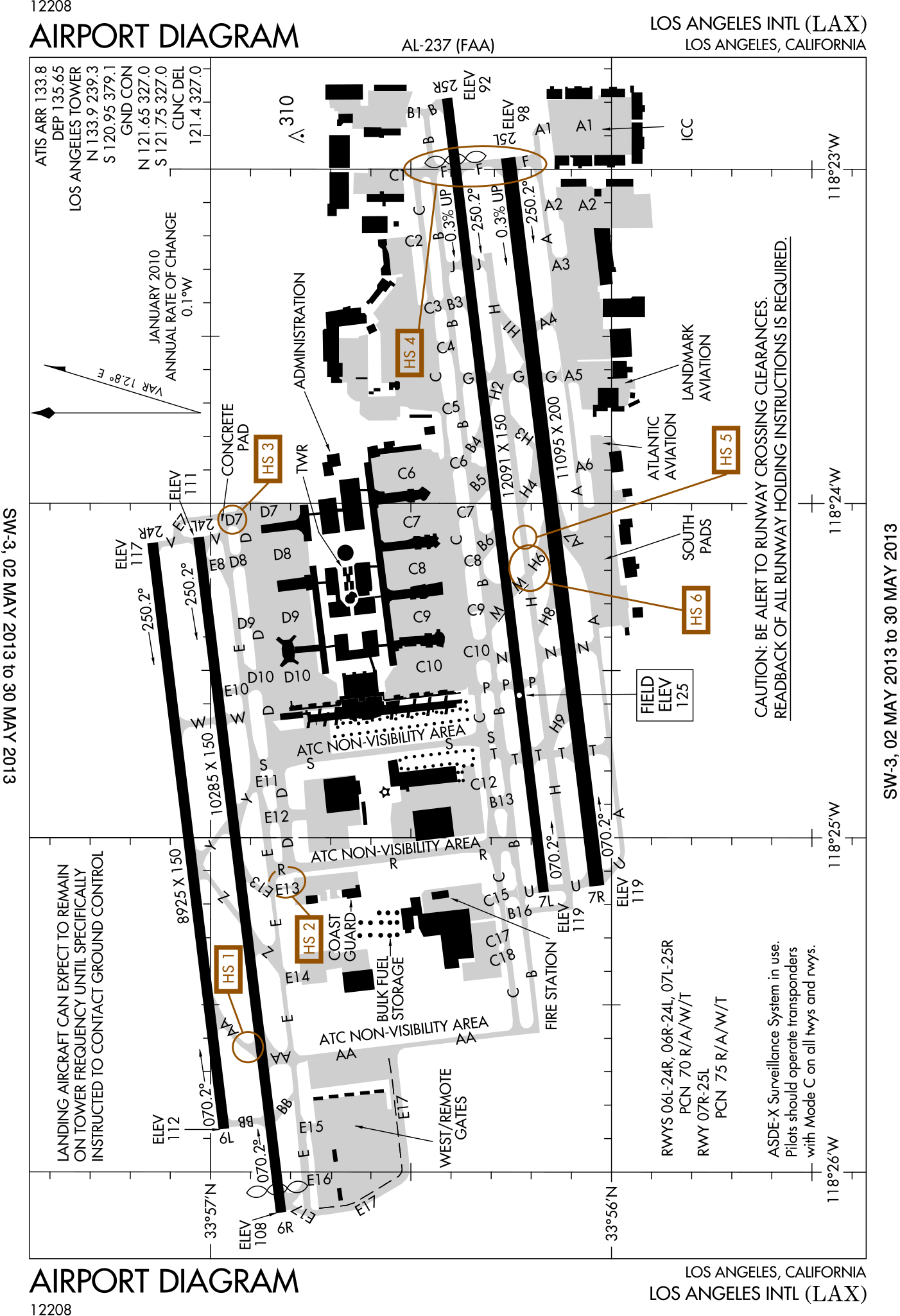
English: FAA Airport Diagram of Los Angeles International Airport. |
| Data | |
| Font |
FAA Airport Diagrams; note that these change every 28 days. Taken from PDF on FAA site and converted to SVG using en:Wikipedia:How to draw SVG circuits using Xcircuit. |
| Autor | Produced by the National Aeronautical Charting Office (NACO), a department of the United States en:Federal Aviation Administration. |
| Posició de la càmera | | Aquesta i altres imatges properes a: OpenStreetMap |
|---|
W3C-validity not checked.
Llicència[modifica]
This image or file is a work of a Federal Aviation Administration employee, taken or made as part of that person's official duties. As a work of the U.S. federal government, the image is in the public domain in the United States.
|
 |
Historial del fitxer
Cliqueu una data/hora per veure el fitxer tal com era aleshores.
| Data/hora | Miniatura | Dimensions | Usuari/a | Comentari | |
|---|---|---|---|---|---|
| actual | 14:22, 2 maig 2013 | | 378 × 552 (1,09 Mo) | Grendelkhan (discussió | contribucions) | SVG version of FAA's PDF diagram. |
No podeu sobreescriure aquest fitxer.
Ús del fitxer
Les 6 pàgines següents utilitzen aquest fitxer:
Ús global del fitxer
Utilització d'aquest fitxer en altres wikis:
- Utilització a ca.wikipedia.org
- Utilització a cs.wikipedia.org
- Utilització a da.wikipedia.org
- Utilització a de.wikipedia.org
- Utilització a it.wikipedia.org
- Utilització a mr.wikipedia.org
- Utilització a www.wikidata.org