File:LaIlustracionArgentina.jpg

Archivo original (4635 × 3576 píxeles; tamaño de archivo: 2,29 MB; tipo MIME: image/jpeg)
Leyendas
Leyendas
Resumen
[editar]
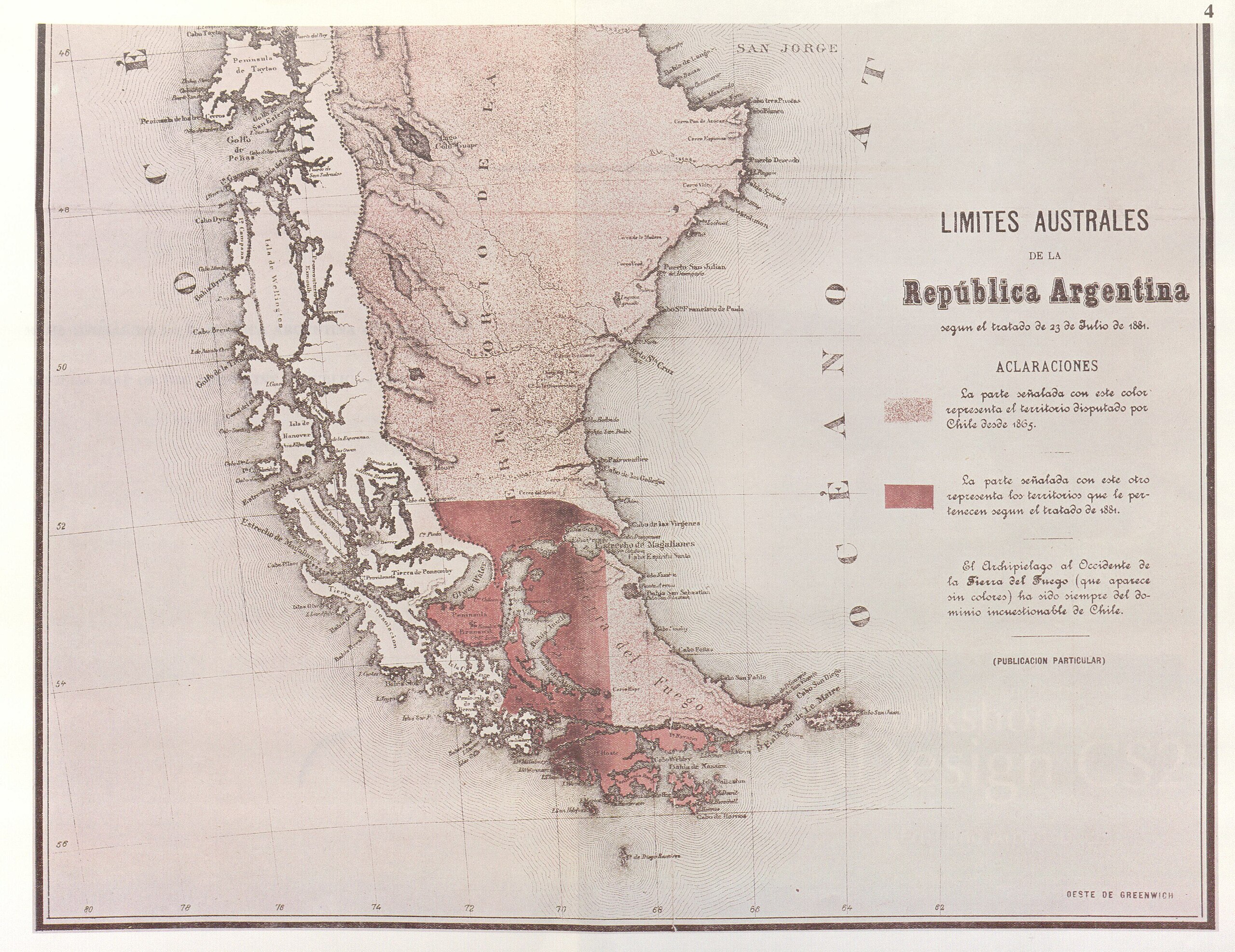
| Descripción | Parcial reproduction of the first argentinian map showing the boundaries laid down in the Boundary Treaty of 23 July 1881, appeared in "La Ilustracion Argentina" issue of 10 November 1881 in Buenos Aires. The copy reproduced here is one handed to the British Minister Plenipontentiary in Buenos Aires by Dr. Bernardo de Irigoyen, Argentine Minister of Forein Affairs who negotiated and signed the Boundary Treaty. The original is located in the official British Archives. The British Minister sent it to his Government with the comment that the dark shaded area "comprising the Strait of Magellan, half of Tierra del Fuego and all the southern islands, represent was actually has been ceded to Chile by the recent Treaty." | ||||
| Fecha | |||||
| Fuente | Relaciones Chileno-Argentinas, La controversia del Beagle, edited by chilean Foreign Affairs, Geneve, Switzerland, 1979 | ||||
| Autor | from magazin "La Ilustracion argentina" | ||||
| Permiso (Reutilización de este archivo) |
|
||||
Historial del archivo
Haz clic sobre una fecha y hora para ver el archivo tal como apareció en ese momento.
| Fecha y hora | Miniatura | Dimensiones | Usuario | Comentario | |
|---|---|---|---|---|---|
| actual | 19:32 3 nov 2007 | | 4635 × 3576 (2,29 MB) | Keysanger (discusión | contribs.) | {{Information |Description=Parcial reproduction of the first argentinian map showing the boundaries laid down in the Boundary Treaty of 23 July 1881, appeared in "La Ilustracion Argentina" issue of 10 November 1881 in Buenos Aires. The copy reproduced her |
| 20:13 18 jun 2007 |  | 1836 × 1371 (545 kB) | Keysanger (discusión | contribs.) | {{Information |Description=Parcial reproduction of the first argentinian map showing the boundaries laid down in the Boundary Treaty of 23 July 1881, appeared in "La Ilustracion Argentina" issue of 10 November 1881 in Buenos Aires. The copy reproduced her |
No puedes sobrescribir este archivo.
Usos del archivo
La siguiente página usa este archivo:
- File:Mapa oficial 2.jpg (archivo de redirección)
Uso global del archivo
Las wikis siguientes utilizan este archivo:
- Uso en de.wikipedia.org
- Uso en en.wikipedia.org
- Uso en es.wikipedia.org
- Uso en fr.wikipedia.org
- Uso en he.wikipedia.org