File:La Palma lava flows into the sea ESA23490653.jpeg

Fitxer original (1.181 × 885 píxels, mida del fitxer: 1,14 Mo, tipus MIME: image/jpeg)
Llegendes
Llegendes
Resum
[modifica]
| Descripció |
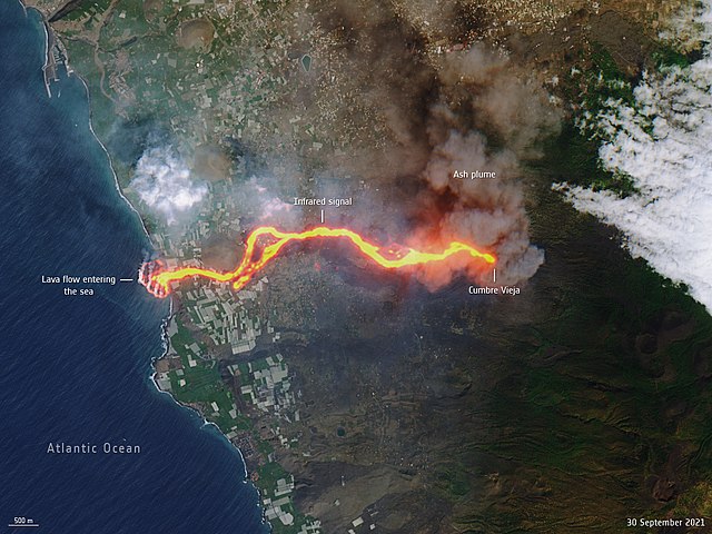
English: This image, captured by the Copernicus Sentinel-2 mission on 30 September, shows the flow of lava from the volcano erupting on the Spanish island of La Palma. The cascade of lava can be seen spilling into the Atlantic Ocean, extending the size of the coastline. This ‘lava delta’ covered about 20 hectares when the image was taken. A crack opened in the Cumbre Vieja volcano on 19 September, throwing plumes of ash and lava into the air. Lava flowed down the mountain and through villages engulfing everything in its path. By 28 September, the 6-km lava flow had reached the ocean on the island’s west coast. Clouds of white steam were reported where the red-hot lava hit the water in the Playa Nueva area. This Sentinel-2 image has been processed in true colour, using the shortwave infrared channel to highlight the lava flow. The Sentinel-2 mission is based on a constellation of two identical satellites, each carrying an innovative wide swath high-resolution multispectral imager with 13 spectral bands for monitoring changes in Earth’s land and vegetation. |
|||||||||
| Activity | Observing the Earth | |||||||||
| Mission | Sentinel-2 | |||||||||
| System | Copernicus | |||||||||
| Data | 1r d'octubre de 2021 (upload date) | |||||||||
| Font | La Palma lava flows into the sea | |||||||||
| Creador |
European Space Agency |
|||||||||
| Geotemporal data | ||||||||||
| Bounding box |
|
|||||||||
| Georeferencing | ||||||||||
Llicència
[modifica]

|
This image contains data from a satellite in the Copernicus Programme, such as Sentinel-1, Sentinel-2 or Sentinel-3. Attribution is required when using this image.
Reconeixement: Contains modified Copernicus Sentinel data 2021
The use of Copernicus Sentinel Data is regulated under EU law (Commission Delegated Regulation (EU) No 1159/2013 and Regulation (EU) No 377/2014). Relevant excerpts:
Free access shall be given to GMES dedicated data [...] made available through GMES dissemination platforms [...].
Access to GMES dedicated data [...] shall be given for the purpose of the following use in so far as it is lawful:
GMES dedicated data [...] may be used worldwide without limitations in time.
GMES dedicated data and GMES service information are provided to users without any express or implied warranty, including as regards quality and suitability for any purpose. |
This media was created by the European Space Agency (ESA).
Where expressly so stated, images or videos are covered by the Creative Commons Attribution-ShareAlike 3.0 IGO (CC BY-SA 3.0 IGO) licence, ESA being an Intergovernmental Organisation (IGO), as defined by the CC BY-SA 3.0 IGO licence. The user is allowed under the terms and conditions of the CC BY-SA 3.0 IGO license to Reproduce, Distribute and Publicly Perform the ESA images and videos released under CC BY-SA 3.0 IGO licence and the Adaptations thereof, without further explicit permission being necessary, for as long as the user complies with the conditions and restrictions set forth in the CC BY-SA 3.0 IGO licence, these including that:
See the ESA Creative Commons copyright notice for complete information, and this article for additional details.
|
 | |
This file is licensed under the Creative Commons Attribution-ShareAlike 3.0 IGO license. Reconeixement: ESA, CC BY-SA IGO 3.0
| ||
| Anotacions | Aquesta imatge té anotacions: Vegeu-les a Commons |
Historial del fitxer
Cliqueu una data/hora per veure el fitxer tal com era aleshores.
| Data/hora | Miniatura | Dimensions | Usuari/a | Comentari | |
|---|---|---|---|---|---|
| actual | 15:01, 1 oct 2021 | | 1.181 × 885 (1,14 Mo) | OptimusPrimeBot (discussió | contribucions) | #Spacemedia - Upload of https://www.esa.int/var/esa/storage/images/esa_multimedia/images/2021/10/la_palma_lava_flows_into_the_sea/23490642-1-eng-GB/La_Palma_lava_flows_into_the_sea.jpg via Commons:Spacemedia |
No podeu sobreescriure aquest fitxer.
Ús del fitxer
No hi ha pàgines que utilitzin aquest fitxer.
Ús global del fitxer
Utilització d'aquest fitxer en altres wikis:
- Utilització a ca.wikipedia.org
- Utilització a en.wikipedia.org
- Utilització a es.wikipedia.org
- Utilització a fr.wikipedia.org
- Utilització a ga.wikipedia.org
- Utilització a is.wikipedia.org
- Utilització a pt.wikipedia.org
- Utilització a sl.wikipedia.org
Metadades
- September 2021 Cumbre Vieja volcanic eruption - satellite pictures
- Photos of Spain by Sentinel-2
- Lava ocean entry
- Active lava deltas
- Eruption columns of the 2021 Cumbre Vieja volcanic eruption (satellite pictures)
- Volcanic ash in La Palma
- Lava flows of the 2021 Cumbre Vieja volcanic eruption
- Puerto de Tazacorte
- Montaña de La Laguna
- Montaña de Todoque
- Montaña de Triana
- Lava ocean entry in 2021