File:Lage des Regierungsbezirkes Dresden in Deutschland.GIF
Jump to navigation
Jump to search
No higher resolution available.
Lage_des_Regierungsbezirkes_Dresden_in_Deutschland.GIF (176 × 234 pixels, file size: 3 KB, MIME type: image/gif)
Captions
Captions
Add a one-line explanation of what this file represents
Summary[edit]
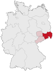
| Description | Regierungsbezirk Dresden in Saxony |
| Date | |
| Source | Karte erstellt auf der Grundlage der opengeodb.de-Umrisse by Geograv |
| Author | Geograv |
This image was generated with OpenGeoDB. The information there is placed in the public domain, images generated from OpenGeoDB are derivative works without passing the threshold of creativity, they are therefore also public domain.
| This work is ineligible for copyright and therefore in the public domain because it consists entirely of information that is common property and contains no original authorship. |
File history
Click on a date/time to view the file as it appeared at that time.
| Date/Time | Thumbnail | Dimensions | User | Comment | |
|---|---|---|---|---|---|
| current | 00:46, 24 February 2006 | | 176 × 234 (3 KB) | Shaqspeare (talk | contribs) | Regierungsbezirk Dresden in Saxony from German Wikipedia, there described as Karte erstellt auf der Grundlage der opengeodb.de-Umrisse - GNU-FDL {{Bild-GFDL-OpenGeoDB}} {{GFDL}} category:Maps of Germany |
You cannot overwrite this file.
File usage on Commons
There are no pages that use this file.
File usage on other wikis
The following other wikis use this file:
- Usage on da.wikipedia.org
- Usage on de.wikipedia.org
- Usage on eo.wikipedia.org
- Usage on es.wikipedia.org
- Usage on et.wikipedia.org
- Usage on fi.wikipedia.org
- Usage on fr.wikipedia.org
- Usage on ko.wikipedia.org
- Usage on nl.wikipedia.org
- Usage on pl.wikipedia.org
- Usage on pl.wikivoyage.org
- Usage on pt.wikipedia.org
- Usage on ru.wikipedia.org
- Usage on uk.wikipedia.org
- Usage on zh.wikipedia.org