File:Lagekarte Nordrussischer Landrücken.png
跳至導覽
跳至搜尋

預覽大小:737 × 599 像素。 其他解析度:295 × 240 像素 | 590 × 480 像素 | 944 × 768 像素 | 1,259 × 1,024 像素 | 2,046 × 1,664 像素。
原始檔案 (2,046 × 1,664 像素,檔案大小:2.97 MB,MIME 類型:image/png)
說明
說明
添加單行說明來描述出檔案所代表的內容
| 描述 |
|
| 日期 | |
| 來源 |
自己的作品, using:
|
| 作者 | Maximilian Dörrbecker (Chumwa) |
| 授權許可 (重用此檔案) |
我,本作品的著作權持有者,決定用以下授權條款發佈本作品: 此檔案採用創用CC 姓名標示-相同方式分享 2.5 通用版授權條款。
Sie dürfen das Bild zu den folgenden Bedingungen nutzen:
|
檔案歷史
點選日期/時間以檢視該時間的檔案版本。
| 日期/時間 | 縮圖 | 尺寸 | 用戶 | 備註 | |
|---|---|---|---|---|---|
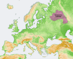
| 目前 | 2009年10月7日 (三) 18:44 | | 2,046 × 1,664(2.97 MB) | Chumwa(對話 | 貢獻) | {{Information |Description= *{{ de }} Landschaften der Osteuropäischen Ebene: Nordrussischer Landrücken |Source={{Own}}, using: *this file, based on a map by San Jose whi |
無法覆蓋此檔案。
檔案用途
下列2個頁面有用到此檔案:
全域檔案使用狀況
以下其他 wiki 使用了這個檔案:
- da.wikipedia.org 的使用狀況
- de.wikipedia.org 的使用狀況
- en.wikipedia.org 的使用狀況
- es.wikipedia.org 的使用狀況
- fi.wikipedia.org 的使用狀況
- fr.wikipedia.org 的使用狀況
- hy.wikipedia.org 的使用狀況
- it.wikipedia.org 的使用狀況
- uk.wikipedia.org 的使用狀況
- www.wikidata.org 的使用狀況
- zh.wikipedia.org 的使用狀況