File:Lake Chad.jpg
跳至導覽
跳至搜尋
預覽大小:750 × 600 像素。 其他解析度:300 × 240 像素 | 600 × 480 像素 | 960 × 768 像素 | 1,280 × 1,024 像素 | 1,400 × 1,120 像素。
原始檔案 (1,400 × 1,120 像素,檔案大小:94 KB,MIME 類型:image/jpeg)
說明
說明
添加單行說明來描述出檔案所代表的內容
摘要
[編輯]
| 描述 |
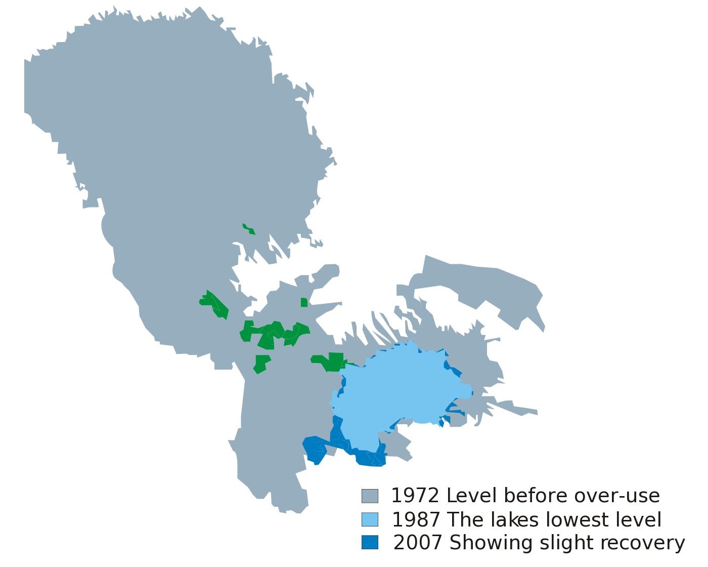
Blank map of Africa W3C-validity not checked. |
| 日期 | (UTC) |
| 來源 | |
| 作者 |
|
| 這是一張修飾過的圖片,即本圖片是用軟體修改過後的版本,修改的方式或內容有:cut some portion of the file。原版圖片來源:Lake Chad map showing receding water area and level 1972-2007.svg。修改者:Alexchris。
|
授權條款
[編輯]
| 我,此作品的版權所有人,釋出此作品至公共領域。此授權條款在全世界均適用。 這可能在某些國家不合法,如果是的話: 我授予任何人有權利使用此作品於任何用途,除受法律約束外,不受任何限制。 |
原始上傳日誌
[編輯]
This image is a derivative work of the following images:
- File:Lake_Chad_map_showing_receding_water_area_and_level_1972-2007.svg licensed with PD-self
- 2010-02-28T04:33:44Z Chaosdruid 2440x1373 (157736 Bytes) Correcting area displayed to full instead of A4 cutoff
- 2010-02-28T04:29:38Z Chaosdruid 744x1052 (140458 Bytes) {{Information |Description=Blank map of Africa{{ValidSVG}} |Source=*[[:File:Blank_Map-Africa.svg|]] |Date=2010-02-28 04:27 (UTC) |Author=*[[:File:Blank_Map-Africa.svg|]]: [[User:Andreas 06|Andreas 06]] *derivative work: ~~~ |
Uploaded with derivativeFX
檔案歷史
點選日期/時間以檢視該時間的檔案版本。
| 日期/時間 | 縮圖 | 尺寸 | 用戶 | 備註 | |
|---|---|---|---|---|---|
| 目前 | 2023年6月12日 (一) 07:01 | | 1,400 × 1,120(94 KB) | Newbamboo(對話 | 貢獻) | new |
| 2011年10月31日 (一) 15:37 |  | 1,400 × 1,249(85 KB) | Alexchris(對話 | 貢獻) | == {{int:filedesc}} == {{Information |Description=Blank map of Africa{{ValidSVG}} |Source=*File:Lake_Chad_map_showing_receding_water_area_and_level_1972-2007.svg |Date=2011-10-31 15:35 (UTC) |Author=*[[:File:Lake_Chad_map_showing_receding_water_area |
無法覆蓋此檔案。
檔案用途
沒有使用此檔案的頁面。
全域檔案使用狀況
以下其他 wiki 使用了這個檔案:
- cs.wikipedia.org 的使用狀況
- en.wikipedia.org 的使用狀況
- es.wikipedia.org 的使用狀況
- gl.wikipedia.org 的使用狀況
- sc.wikipedia.org 的使用狀況
- uk.wikipedia.org 的使用狀況
- zh.wikipedia.org 的使用狀況