File:Lake Chilwa, Malawi.jpg

Original file (2,500 × 1,558 pixels, file size: 2.75 MB, MIME type: image/jpeg)
Captions
Captions
Summary
[edit]
| Description |
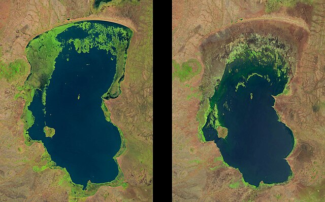
Afrikaans: Chilwameer is 'n vlak, landgeslote soutmeer. Dit is langs die Skeurvallei in die suide van Malawi geleë, in die nabye van die Mosambiekse grens. Die diepte daarvan word sterk deur reënval en somerverdampingspatrone beïnvloed, en in onlangse jare het dit gekrimp. Omdat die bekken 'n plaaslik belangrike bron van rys- en visproduksie is, skep die huidige droogtetendens kommer oor voedselsekerheid.
Hierdie Landsat-beelde toon die netto afname in meeroppervlakte tussen Oktober 1990 en November 2013. Die twee beelde toon ook veranderinge in die uitgebreide vleilande (heldergroen) wat Chilwameer omring. Hierdie vleilande word internasionaal as 'n belangrike seisoenale verblyfplek vir trekvoëls uit die Noordelike Halfrond erken. Landsat-data is uiters nuttig vir wetenskaplikes en owerhede om veranderinge in waterhulpbronne en grondbedekking te moniteer.English: Lake Chilwa is a shallow, enclosed saline lake located along the East African Rift Valley in southern Malawi, near its border with Mozambique.
This lake experiences high water level fluctuation, as it is strongly influenced by rainfall and summer evaporation patterns. In recent years, Lake Chilwa has been shrinking. Because the basin is an important source of local rice and fish production, the current drying trend is a potential food security concern. These Landsat images show the net reduction of lake area between October 1990 and November 2013. The two images also show changes to the extensive wetlands (bright green) that surround Lake Chilwa. These wetlands are internationally recognized as an important seasonal hosting location for migratory birds from the Northern Hemisphere. Landsat data are extremely useful for scientists and authorities to monitor water resources and land cover changes over time. #USGS #Landsat #satellite #lake #water #climate #environment #economics #food #Africa #waterloss |
| Date | 1990-10; 2013-11 |
| Source | https://www.flickr.com/photos/27784370@N05/11963785293/ |
| Author | U.S. Geological Survey |
Licensing
[edit]
| This file is made available under the Creative Commons CC0 1.0 Universal Public Domain Dedication. | |
| The person who associated a work with this deed has dedicated the work to the public domain by waiving all of their rights to the work worldwide under copyright law, including all related and neighboring rights, to the extent allowed by law. You can copy, modify, distribute and perform the work, even for commercial purposes, all without asking permission.
|
| This image was originally posted to Flickr by U.S. Geological Survey at https://flickr.com/photos/27784370@N05/11963785293. It was reviewed on 19 January 2022 by FlickreviewR 2 and was confirmed to be licensed under the terms of the cc-zero. |
File history
Click on a date/time to view the file as it appeared at that time.
| Date/Time | Thumbnail | Dimensions | User | Comment | |
|---|---|---|---|---|---|
| current | 06:10, 19 January 2022 | | 2,500 × 1,558 (2.75 MB) | Ooligan (talk | contribs) | Uploaded a work by U.S. Geological Survey from https://www.flickr.com/photos/27784370@N05/11963785293/ with UploadWizard |
You cannot overwrite this file.
File usage on Commons
The following page uses this file:
File usage on other wikis
The following other wikis use this file:
- Usage on nl.wikipedia.org