File:Lakebalkhashbasinmap.png
跳至導覽
跳至搜尋

預覽大小:800 × 546 像素。 其他解析度:320 × 218 像素 | 640 × 437 像素 | 1,024 × 698 像素 | 1,466 × 1,000 像素。
原始檔案 (1,466 × 1,000 像素,檔案大小:1.52 MB,MIME 類型:image/png)
說明
說明
添加單行說明來描述出檔案所代表的內容
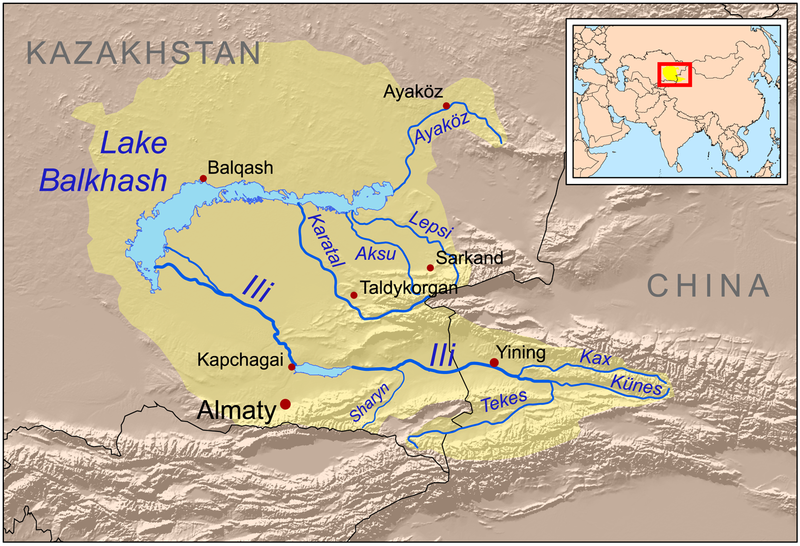
| 描述 | This is a map of the Lake Balkhash drainage basin, including the Ili River and its tributaries. |
| 日期 | |
| 來源 | Own work using Digital Chart of the World and GTOPO data, labels based on GEOnet. UNEP and Decrease of river runoff in the Lake Balkhash basin in Central Asia by Kader Kezer and Hiroshi Matsuyama used as references. |
| 作者 | Kmusser |
| 其他版本 | Magyar svg |
我,本作品的著作權持有者,決定用以下授權條款發佈本作品:
此檔案採用創用CC 姓名標示-相同方式分享 3.0 未在地化版本授權條款。
- 您可以自由:
- 分享 – 複製、發佈和傳播本作品
- 重新修改 – 創作演繹作品
- 惟需遵照下列條件:
- 姓名標示 – 您必須指名出正確的製作者,和提供授權條款的連結,以及表示是否有對內容上做出變更。您可以用任何合理的方式來行動,但不得以任何方式表明授權條款是對您許可或是由您所使用。
- 相同方式分享 – 如果您利用本素材進行再混合、轉換或創作,您必須基於如同原先的相同或兼容的條款,來分布您的貢獻成品。
檔案歷史
點選日期/時間以檢視該時間的檔案版本。
| 日期/時間 | 縮圖 | 尺寸 | 使用者 | 備註 | |
|---|---|---|---|---|---|
| 目前 | 2008年12月22日 (一) 21:01 | | 1,466 × 1,000(1.52 MB) | Kmusser(留言 | 貢獻) | {{Information |Description=This is a map of the Lake Balkhash drainage basin, including the Ili River and its tributaries. |Source=Own work using http://www.maproom.psu.edu/dcw/ Digital Chart of the World and [ |
無法覆蓋此檔案。
檔案用途
下列2個頁面有用到此檔案:
全域檔案使用狀況
以下其他 wiki 使用了這個檔案:
- af.wikipedia.org 的使用狀況
- ar.wikipedia.org 的使用狀況
- arz.wikipedia.org 的使用狀況
- ast.wikipedia.org 的使用狀況
- azb.wikipedia.org 的使用狀況
- az.wikipedia.org 的使用狀況
- ba.wikipedia.org 的使用狀況
- bg.wikipedia.org 的使用狀況
- bn.wikipedia.org 的使用狀況
- bs.wikipedia.org 的使用狀況
- ca.wikipedia.org 的使用狀況
- cs.wikipedia.org 的使用狀況
- da.wikipedia.org 的使用狀況
- de.wikipedia.org 的使用狀況
- el.wikipedia.org 的使用狀況
- en.wikipedia.org 的使用狀況
檢視此檔案的更多全域使用狀況。