File:Landlocked countries.png
Zur Navigation springen
Zur Suche springen
Greßi vu däre Vorschau: 800 × 351 Pixel. Wyteri Ufflösige: 320 × 140 Pixel | 640 × 281 Pixel | 1.425 × 625 Pixel.
Originaldatei (1.425 × 625 Pixel, Dateigrößi: 54 KB, MIME-Typ: image/png)
Bildtexte
Kurzbeschreibungen
Ergänze eine einzeilige Erklärung, was diese Datei darstellt.
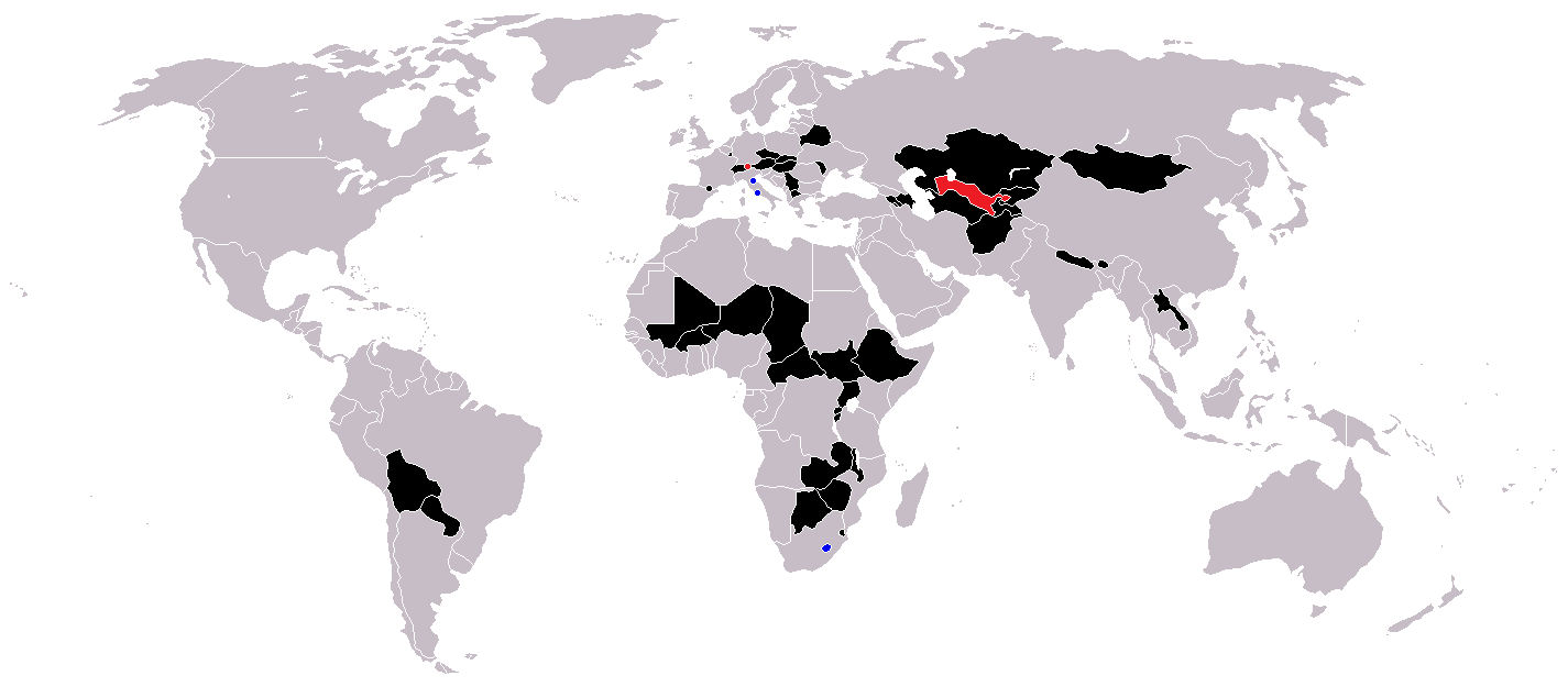
Binnenstaaten der Welt

|
Please translate the English parts of this template into Alemannisch.
Säll Bild gitt's au in als Vektorgrafik (SVG). Wenn's besser isch, no benutz säll anstell vu dem Rasterbild. File:Landlocked countries.png → File:Landlocked countries.svg
Meh zu Vektorgrafike findsch unter Wechsel zu SVG. Zu de Unterstützig vu SVG durch d'MediaWiki-Software lüeg unter SVG image support uff Meta. |
 |
Bschryybig
[ändere]
| Bschryybig | |
| Datum | |
| Quälle | Eigeni Arbet |
| Urheber | Ævar Arnfjörð Bjarmason |
Countries coloured black on the map
[ändere]
Countries coloured red on the map (double landlocked)
[ändere]
Countries coloured blue on the map (landlocked by a single country)
[ändere]
Lizänzierig
[ändere]
| Ich, dr Urheberrächtsinhaber vu däm Wärch, tue s as gmeinfrej vereffentlige . Des giltet wältwyt. In mänke Staate chennt des rächtli nit megli syy. Wänn des imfall eso isch: Ich gib e jedem s bedingiglos Rächt, des Wärch jedwädere Zwäck z nutze, ußer s git gesetzlig erforderligi Bedingige. |
Dateiversione
Klick uf e Zytpunkt zu aazeige, wie s dert usgsäh het.
| Version vom | Vorschaubild | Mäß | Benutzer | Kommentar | |
|---|---|---|---|---|---|
| aktuell | 12:36, 1. Jun. 2018 | | 1.425 × 625 (54 KB) | LamBoet (Diskussion | Byträg) | Reverted to version as of 16:39, 15 July 2011 (UTC) - Restore blue color for countries that are landlocked by a single country |
| 21:34, 2. Apr. 2018 |  | 1.425 × 625 (37 KB) | Maphobbyist (Diskussion | Byträg) | Check | |
| 21:03, 2. Apr. 2018 |  | 1.425 × 625 (37 KB) | Maphobbyist (Diskussion | Byträg) | Black coloring for San Marino, Vatican and Lesotho. | |
| 16:39, 15. Jul. 2011 |  | 1.425 × 625 (54 KB) | Hoshie (Diskussion | Byträg) | added South Sudan and added circles foe European microsates | |
| 13:47, 27. Sep. 2010 |  | 1.425 × 625 (48 KB) | (지금은) 소년시대 (Diskussion | Byträg) | + Landlocked by a single country | |
| 05:33, 23. Okt. 2008 |  | 1.425 × 625 (48 KB) | IngSoc BigBrother (Diskussion | Byträg) | ||
| 16:14, 25. Feb. 2007 |  | 1.425 × 625 (30 KB) | Aivazovsky~commonswiki (Diskussion | Byträg) | ||
| 09:29, 23. Mei 2006 |  | 1.357 × 628 (46 KB) | Stefan040780 (Diskussion | Byträg) | source: same as old map, updated on 23.5.06 by stefan040780 | |
| 03:08, 21. Jun. 2005 |  | 1.357 × 628 (25 KB) | Ævar Arnfjörð Bjarmason (Diskussion | Byträg) | Landlocked countries, based on Image:BlankMap-World.png. Category:World maps |
Du chasch die Datei nit iberschryybe.
Verwändig vu dr Datei
Kei Artikel bruucht die Datei.
Wältwyti Dateinutzig
Die andere Wikis bruche die Datei:
- Gebruch uf ckb.wikipedia.org
- Gebruch uf da.wikipedia.org
- Gebruch uf eu.wikipedia.org
- Gebruch uf fa.wikipedia.org
- Gebruch uf fo.wikipedia.org
- Gebruch uf fr.wikipedia.org
- Gebruch uf hr.wikipedia.org
- Gebruch uf hu.wikipedia.org
- Gebruch uf is.wiktionary.org
- Gebruch uf ja.wikipedia.org
- Gebruch uf ja.wiktionary.org
- Gebruch uf kk.wikipedia.org
- Gebruch uf ko.wikipedia.org
- Gebruch uf mk.wikipedia.org
- Gebruch uf ms.wikipedia.org
- Gebruch uf nso.wikipedia.org
- Gebruch uf te.wikipedia.org
- Gebruch uf uk.wikipedia.org
- Gebruch uf vi.wikipedia.org
- Gebruch uf zh-yue.wikipedia.org