File:Landsat 8 launch.jpg
跳至導覽
跳至搜尋

預覽大小:480 × 600 像素。 其他解析度:192 × 240 像素 | 384 × 480 像素 | 614 × 768 像素 | 819 × 1,024 像素 | 2,400 × 3,000 像素。
原始檔案 (2,400 × 3,000 像素,檔案大小:994 KB,MIME 類型:image/jpeg)
說明
說明
添加單行說明來描述出檔案所代表的內容
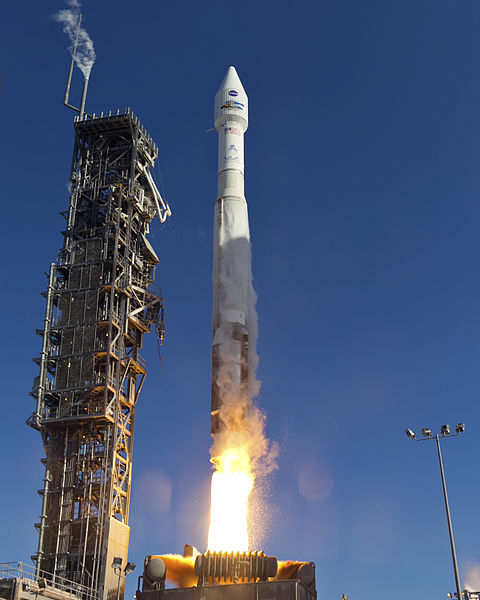
| 描述 | VANDENBERG AFB, Calif. -- The Landsat Data Continuity Mission spacecraft lifted off on 11 February 2013 at 1:02 p.m. EST (10:02 a.m. PST, 18:02 UTC) atop a United Launch Alliance Atlas V rocket from Space Launch Complex 3 at California's Vandenberg Air Force Base. The Landsat Data Continuity Mission LDCM is the future of Landsat satellites. It will continue to obtain valuable data and imagery to be used in agriculture, education, business, science, and government. The Landsat Program provides repetitive acquisition of high resolution multispectral data of the Earth's surface on a global basis. The data from the Landsat spacecraft constitute the longest record of the Earth's continental surfaces as seen from space. It is a record unmatched in quality, detail, coverage, and value. For more information, visit: http://www.nasa.gov/mission_pages/landsat/main/index.html |
| 日期 | 攝於2013年二月11日, 18:02 |
| 來源 | http://mediaarchive.ksc.nasa.gov/detail.cfm?mediaid=64296 (archive link); see also https://images.nasa.gov/details/2013-1435 |
| 作者 | United Launch Alliance/Patrick H. Corkery |
| 授權許可 (重用此檔案) |
Per source: "No copyright protection is asserted for this photograph. If a recognizable person appears in this photograph, use for commercial purposes may infringe a right of privacy or publicity. It may not be used to state or imply the endorsement by NASA employees of a commercial product, process or service, or used in any other manner that might mislead. Accordingly, it is requested that if this photograph is used in advertising and other commercial promotion, layout and copy be submitted to NASA prior to release." |
本圖像或影音收錄於美國國家航空暨太空總署 (NASA)甘迺迪太空中心(Kennedy Space Center),其照片編號為: KSC-2013-1435 此標籤不表示文件的著作權狀態。任何文件在附有此標籤的同時還需要一個有效的著作權標籤。請參閱許可協議說明頁面以了解更多資訊。 其他語言:
|
授權條款
[編輯]
| 此作品已由其作者,United Launch Alliance/Patrick H. Corkery,釋出至公有領域。此授權條款在全世界均適用。 這可能在某些國家不合法,如果是的話: United Launch Alliance/Patrick H. Corkery授予任何人有權利使用此作品於任何用途,除受法律約束外,不受任何限制。
|
檔案歷史
點選日期/時間以檢視該時間的檔案版本。
| 日期/時間 | 縮圖 | 尺寸 | 用戶 | 備註 | |
|---|---|---|---|---|---|
| 目前 | 2013年2月12日 (二) 14:15 | | 2,400 × 3,000(994 KB) | WDGraham(對話 | 貢獻) | {{Information |Description=VANDENBERG AFB, Calif. -- The Landsat Data Continuity Mission spacecraft lifted off at 1:02 p.m. EST, 10:02 a.m. PST) <nowiki>[</nowiki>''sic''<nowiki>]</nowiki> atop a United Launch Alliance Atlas V rocket fr... |
無法覆蓋此檔案。
檔案用途
全域檔案使用狀況
以下其他 wiki 使用了這個檔案:
- en.wikipedia.org 的使用狀況
- fr.wikipedia.org 的使用狀況
- ru.wikipedia.org 的使用狀況
- zh.wikipedia.org 的使用狀況