File:Landslide in Southern China.jpg
پرش به ناوبری
پرش به جستجو

اندازهٔ این پیشنمایش: ۶۰۰ × ۶۰۰ پیکسل. کیفیتهای دیگر: ۲۴۰ × ۲۴۰ پیکسل | ۴۸۰ × ۴۸۰ پیکسل | ۷۶۸ × ۷۶۸ پیکسل | ۱٬۰۲۴ × ۱٬۰۲۴ پیکسل | ۲٬۰۰۰ × ۲٬۰۰۰ پیکسل.
پروندهٔ اصلی (۲٬۰۰۰ × ۲٬۰۰۰ پیکسل، اندازهٔ پرونده: ۱٫۷ مگابایت، نوع MIME پرونده: image/jpeg)
گزینهها
عنوان
شرحی یکخطی از محتوای این فایل اضافه کنید
خلاصه[ویرایش]
| توضیح |
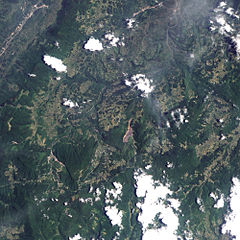
English: A landslide in the Chongqing region of southern China. The landslide dropped some 12 million cubic meters onto several homes and an iron ore mine, trapping dozens of people. Mountain ridges run generally north-south through this area, and the landslide occurs on the western slope of the middle ridge shown in the image. A giant brown scar of bare land on an otherwise vegetated landscape, the landslide fans out toward the south west. The mountainside collapse appears to affect two roads—one road running along the top of the ridge, which borders the landslide, and another road to the west, which the landslide has partially buried. |
| تاریخ | |
| منبع | NASA Earth Observatory |
| پدیدآور | Jesse Allen |
Image created using EO-1 ALI data provided courtesy of the NASA EO-1 Team. Instrument: EO-1 - ALI
اجازهنامه[ویرایش]
| این پرونده در مالکیت عمومی قرار دارد چرا که توسط ناسا ایجاد شده است. سیاست حق تکثیر ناسا بیان میکند که «مواد ناسا با حق تکثیر محافظت نمیشوند، مگراینکه ذکر شده باشد». (Template:PD-USGov، صفحهٔ سیاست حق تکثیر ناسا یا سیاست جیپیال استفاده از تصاویر را ببینید.) | ||
 |
هشدارها:
|
| برچسبها | این نگاره برچسپگذاری شدهاست: برچسپها را در ویکیانبار مشاهده کنید |
تاریخچهٔ پرونده
روی تاریخ/زمانها کلیک کنید تا نسخهٔ مربوط به آن هنگام را ببینید.
| تاریخ/زمان | بندانگشتی | ابعاد | کاربر | توضیح | |
|---|---|---|---|---|---|
| کنونی | ۱۹ ژوئن ۲۰۰۹، ساعت ۰۹:۰۸ | | ۲٬۰۰۰ در ۲٬۰۰۰ (۱٫۷ مگابایت) | Originalwana (بحث | مشارکتها) | {{Information |Description={{en|1=A landslide in the Chongqing region of southern China. The landslide dropped some 12 million cubic meters onto several homes and an iron ore mine, trapping dozens of people. Mountain ridges run generally north-south throu |
شما نمیتوانید این پرونده را رونویسی کنید.
کاربرد پرونده
این پرونده در هیچ صفحهای به کار نرفته است.