File:Language region maps of India.svg

Original file (SVG file, nominally 512 × 583 pixels, file size: 167 KB)
Captions
Captions
Summary
[edit]| Description |
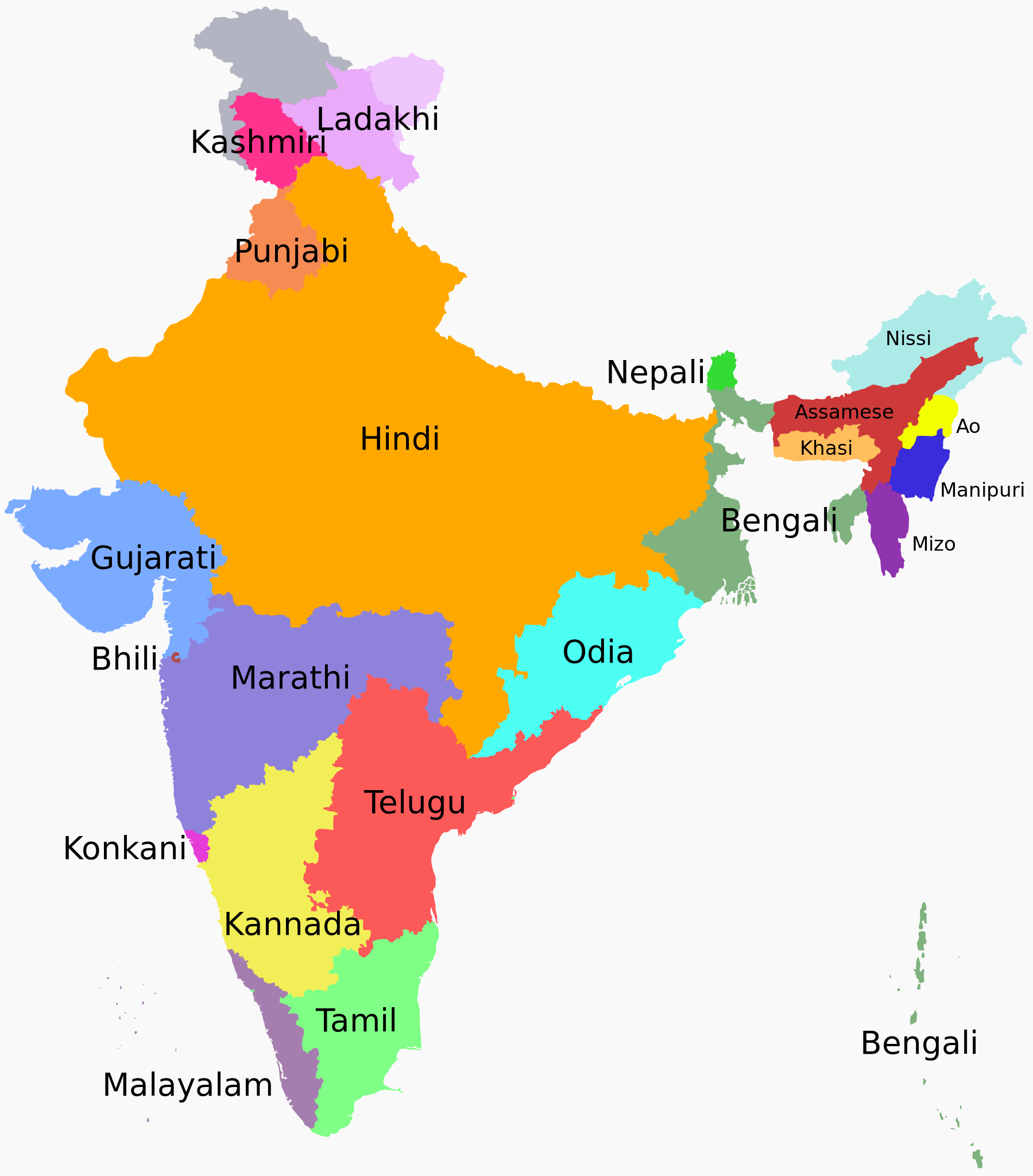
English: States and union territories of India by the most commonly spoken first language.
हिन्दी: भारत के राज्यों और केंद्र शासित प्रदेशों में सबसे अधिक बोली जाने वाली भाषा
বাংলা: ভারতের ভাষা অঞ্চলের মানচিত্র [1]
References
|
| Date | |
| Source | Own work, based on the 'Report of the Commissioner for linguistic minorities', Govt. of India,(July 2012 to June 2013)- NCLM-50th report pdf archive copy at the Wayback Machine |
| Author | Filpro |
| Other versions |
|


Licensing
[edit]
- You are free:
- to share – to copy, distribute and transmit the work
- to remix – to adapt the work
- Under the following conditions:
- attribution – You must give appropriate credit, provide a link to the license, and indicate if changes were made. You may do so in any reasonable manner, but not in any way that suggests the licensor endorses you or your use.
- share alike – If you remix, transform, or build upon the material, you must distribute your contributions under the same or compatible license as the original.
File history
Click on a date/time to view the file as it appeared at that time.
| Date/Time | Thumbnail | Dimensions | User | Comment | |
|---|---|---|---|---|---|
| current | 17:38, 14 October 2023 | | 512 × 583 (167 KB) | Snehrashmi (talk | contribs) | File uploaded using svgtranslate tool (https://svgtranslate.toolforge.org/). Added translation for gu. |
| 12:22, 4 September 2023 |  | 512 × 583 (163 KB) | İsnaaa (talk | contribs) | File uploaded using svgtranslate tool (https://svgtranslate.toolforge.org/). Added translation for tr. | |
| 12:52, 27 August 2023 |  | 512 × 583 (160 KB) | Illchy (talk | contribs) | File uploaded using svgtranslate tool (https://svgtranslate.toolforge.org/). Added translation for id. | |
| 11:42, 25 June 2023 |  | 512 × 583 (159 KB) | Saurabhsaha (talk | contribs) | File uploaded using svgtranslate tool (https://svgtranslate.toolforge.org/). Added translation for as. | |
| 11:38, 25 June 2023 |  | 512 × 583 (155 KB) | Saurabhsaha (talk | contribs) | Reverted to version as of 06:13, 28 December 2020 (UTC). Reason: Actual image was in English where as | |
| 11:36, 25 June 2023 |  | 512 × 583 (159 KB) | Saurabhsaha (talk | contribs) | File uploaded using svgtranslate tool (https://svgtranslate.toolforge.org/). Added translation for as. | |
| 06:13, 28 December 2020 |  | 512 × 583 (155 KB) | फ़िलप्रो (talk | contribs) | Removed Shina as there is no data for the Pakistan-controlled Kashmir region in the Indian census. Chhattisgarhi is treated as a dialect of Hindi as per the Indian census that the map uses as a source. | |
| 15:29, 16 November 2020 |  | 1,476 × 1,680 (249 KB) | Sbb1413 (talk | contribs) | Adjusted the colour of Kashmiri sphere. | |
| 15:25, 16 November 2020 |  | 1,476 × 1,680 (249 KB) | Sbb1413 (talk | contribs) | Added Chhattisgarhi, Ladakhi and Shina. | |
| 17:00, 5 August 2020 |  | 1,476 × 1,680 (239 KB) | Rizorius (talk | contribs) | File uploaded using svgtranslate tool (https://svgtranslate.toolforge.org/). Added translation for fa. |
You cannot overwrite this file.
File usage on Commons
The following 17 pages use this file:
- User:Chinggis6/Favorites
- User:Chumwa/OgreBot/Travel and communication maps/2016 October 1-10
- User:Chumwa/OgreBot/Travel and communication maps/2016 September 11-20
- User:Chumwa/OgreBot/Travel and communication maps/2020 August 1-10
- User:Chumwa/OgreBot/Travel and communication maps/2020 December 21-31
- User:Chumwa/OgreBot/Travel and communication maps/2020 May 1-10
- User:Chumwa/OgreBot/Travel and communication maps/2020 May 11-20
- User:Chumwa/OgreBot/Travel and communication maps/2020 November 11-20
- User:Chumwa/OgreBot/Travel and communication maps/2023 August 21-31
- User:Chumwa/OgreBot/Travel and communication maps/2023 June 21-30
- User:Chumwa/OgreBot/Travel and communication maps/2023 October 11-20
- User:Chumwa/OgreBot/Travel and communication maps/2023 September 1-10
- User:Multila/Favorites
- Commons:Files used on the OpenStreetMap Wiki/38
- File:Language region maps of India-ar.svg
- File:Languages of India.svg (file redirect)
- Category:Official languages of India
File usage on other wikis
The following other wikis use this file:
- Usage on af.wikipedia.org
- Usage on ami.wikipedia.org
- Usage on ast.wikipedia.org
- Usage on as.wikipedia.org
- Usage on azb.wikipedia.org
- Usage on az.wikipedia.org
- Usage on de.wikipedia.org
- Usage on el.wikipedia.org
- Usage on en.wikipedia.org
- Usage on en.wikiquote.org
- Usage on en.wikivoyage.org
- Usage on et.wikipedia.org
- Usage on fa.wikipedia.org
- Usage on fa.wikibooks.org
- Usage on fi.wikipedia.org
- Usage on fr.wikipedia.org
- Usage on gu.wikipedia.org
- Usage on ha.wikipedia.org
- Usage on hi.wikipedia.org
- Usage on id.wikipedia.org
- Usage on incubator.wikimedia.org
- Usage on ja.wikipedia.org
- Usage on kn.wikipedia.org
- Usage on ko.wikipedia.org
- Usage on ks.wikipedia.org
- Usage on lfn.wikipedia.org
- Usage on mk.wikipedia.org
View more global usage of this file.