File:Lasbela.PNG
Jump to navigation
Jump to search

Size of this preview: 656 × 600 pixels. Other resolutions: 263 × 240 pixels | 525 × 480 pixels | 699 × 639 pixels.
Original file (699 × 639 pixels, file size: 23 KB, MIME type: image/png)
Captions
Captions
Add a one-line explanation of what this file represents

|
This locator map image could be re-created using vector graphics as an SVG file. This has several advantages; see Commons:Media for cleanup for more information. If an SVG form of this image is available, please upload it and afterwards replace this template with
{{vector version available|new image name}}.
It is recommended to name the SVG file “Lasbela.svg”—then the template Vector version available (or Vva) does not need the new image name parameter. |
Summary
[edit]
| Description |
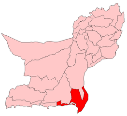
English: Map showing location of Lasbela District within Pakistan |
| Date | 22 July 2006 (original upload date) |
| Source |
Own work (Original caption: "") |
| Author | Aarandir at en.wikipedia |
Licensing
[edit]
Aarandir at the English-language Wikipedia, the copyright holder of this work, hereby publishes it under the following license:
| This file is licensed under the Creative Commons Attribution-Share Alike 3.0 Unported license. Subject to disclaimers. | ||
| Attribution: Aarandir at the English-language Wikipedia | ||
| ||
| This licensing tag was added to this file as part of the GFDL licensing update. |

|
Permission is granted to copy, distribute and/or modify this document under the terms of the GNU Free Documentation License, Version 1.2 or any later version published by the Free Software Foundation; with no Invariant Sections, no Front-Cover Texts, and no Back-Cover Texts. A copy of the license is included in the section entitled GNU Free Documentation License. Subject to disclaimers. |
Original upload log
[edit]
The original description page was here. All following user names refer to en.wikipedia.
- 2006-07-22 10:04 Aarandir 699×639× (23677 bytes)
File history
Click on a date/time to view the file as it appeared at that time.
| Date/Time | Thumbnail | Dimensions | User | Comment | |
|---|---|---|---|---|---|
| current | 12:41, 11 January 2011 | | 699 × 639 (23 KB) | Sentinel R (talk | contribs) | {{Information |Description=Map of Balochistan with Lasbela District highlighted |Source=http://en.wikipedia.org/wiki/File:Lasbela.PNG |Date= |Author=http://en.wikipedia.org/wiki/Special:Contributions/Aarandir |Permission={{GFDL-self-with-disclaimers|migra |
You cannot overwrite this file.
File usage on Commons
There are no pages that use this file.