File:Lausanne - Public transport map.png
跳至導覽
跳至搜尋

預覽大小:800 × 568 像素。 其他解析度:320 × 227 像素 | 640 × 454 像素 | 1,024 × 727 像素 | 1,280 × 909 像素 | 2,556 × 1,815 像素。
原始檔案 (2,556 × 1,815 像素,檔案大小:2.43 MB,MIME 類型:image/png)
說明
說明
添加單行說明來描述出檔案所代表的內容
| 描述 |
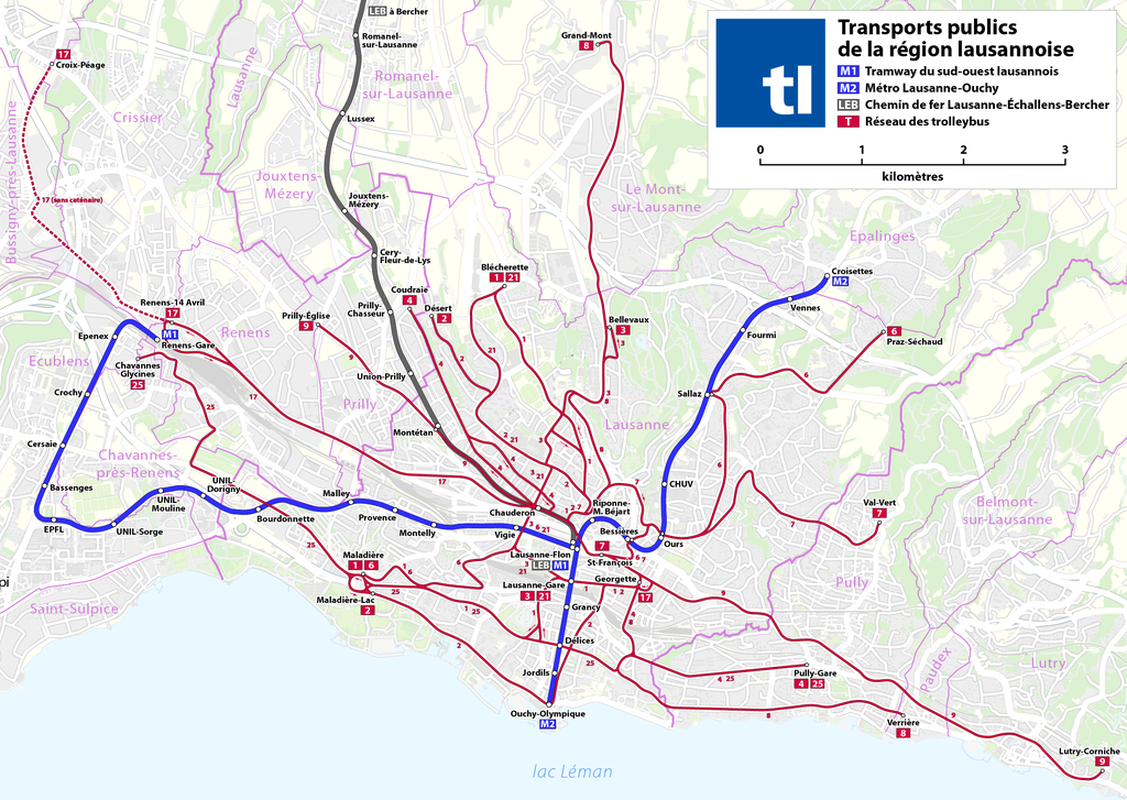
Deutsch: Karte: Metro- und Trolleybus-Netzplan von Lausanne
English: Map of the Lausanne metro and trolleybus network
Français : Plan des réseaux métro et trolleybus de Lausanne |
| 日期 | see file history |
| 來源 | 自己的作品, using OpenStreetMap data for the background |
| 作者 | Maximilian Dörrbecker (Chumwa) |
| 授權許可 (重用此檔案) |
All OpenStreetMap data and maps are Creative Commons "CC-BY-SA 2.0" licensed 此檔案採用創用CC 姓名標示-相同方式分享 2.0 通用版授權條款。
|
| 其他版本 |
|


檔案歷史
點選日期/時間以檢視該時間的檔案版本。
| 日期/時間 | 縮圖 | 尺寸 | 使用者 | 備註 | |
|---|---|---|---|---|---|
| 目前 | 2017年12月24日 (日) 23:07 | | 2,556 × 1,815(2.43 MB) | Chumwa(留言 | 貢獻) | corr |
| 2017年5月27日 (六) 15:41 |  | 2,556 × 1,815(2.43 MB) | Chumwa(留言 | 貢獻) | update | |
| 2016年1月15日 (五) 16:35 |  | 2,518 × 1,815(1.61 MB) | Kopiersperre(留言 | 貢獻) | optipng | |
| 2014年10月12日 (日) 06:05 |  | 2,518 × 1,815(2.37 MB) | Chumwa(留言 | 貢獻) | Extension of route 25 to Chavannes Glycines | |
| 2012年2月13日 (一) 13:38 |  | 2,518 × 1,815(2.34 MB) | Abaddon1337(留言 | 貢獻) | no changes. re-upload to force the recreation of miniatures. | |
| 2011年11月20日 (日) 07:25 |  | 2,518 × 1,815(2.34 MB) | Chumwa(留言 | 貢獻) | {{Information |Description= *{{ de }} Karte: Metro- und Trolleybus-Netzplan von Lausanne *{{ en }} Map of the Lausanne metro and trolleybus network *{{ fr }} Plan des réseaux métro et trolleybus de Lausanne |Author=[[:de:User:Chumwa|Maximilian Dörrbeck |
無法覆蓋此檔案。
檔案用途
下列17個頁面有用到此檔案:
- User:Chumwa/Gallery
- User:Chumwa/OgreBot/Potential transport maps/2016 January 11-20
- User:Chumwa/OgreBot/Potential transport maps/2017 December 21-31
- User:Chumwa/OgreBot/Potential transport maps/2017 May 21-31
- User:Chumwa/OgreBot/Public transport information/2016 January 11-20
- User:Chumwa/OgreBot/Public transport information/2017 December 21-31
- User:Chumwa/OgreBot/Public transport information/2017 May 21-31
- User:Chumwa/OgreBot/Transport Maps/2016 January 11-20
- User:Chumwa/OgreBot/Transport Maps/2017 December 21-31
- User:Chumwa/OgreBot/Transport Maps/2017 May 21-31
- User:Chumwa/OgreBot/Travel and communication maps/2016 January 11-20
- User:Chumwa/OgreBot/Travel and communication maps/2017 December 21-31
- User:Chumwa/OgreBot/Travel and communication maps/2017 May 21-31
- File:Lausanne - Public transport map.png
- File:Metro Lausanne plan synoptique.svg
- File:MetrodeLausanne.JPG
- File:TL M1+M2.png
全域檔案使用狀況
以下其他 wiki 使用了這個檔案:
- ast.wikipedia.org 的使用狀況
- bg.wikipedia.org 的使用狀況
- bn.wikipedia.org 的使用狀況
- ca.wikipedia.org 的使用狀況
- cs.wikipedia.org 的使用狀況
- de.wikipedia.org 的使用狀況
- en.wikipedia.org 的使用狀況
- eo.wikipedia.org 的使用狀況
- es.wikipedia.org 的使用狀況
- fa.wikipedia.org 的使用狀況
- fi.wikipedia.org 的使用狀況
- fr.wikipedia.org 的使用狀況
- he.wikivoyage.org 的使用狀況
- hu.wikipedia.org 的使用狀況
- id.wikipedia.org 的使用狀況
- it.wikipedia.org 的使用狀況
- ko.wikipedia.org 的使用狀況
- lt.wikipedia.org 的使用狀況
- nl.wikipedia.org 的使用狀況
- pl.wikipedia.org 的使用狀況
- rm.wikipedia.org 的使用狀況
- ru.wikipedia.org 的使用狀況
- th.wikipedia.org 的使用狀況
- tr.wikipedia.org 的使用狀況
- uk.wikipedia.org 的使用狀況
- uz.wikipedia.org 的使用狀況
- zh.wikipedia.org 的使用狀況