File:Lava Forks Provincial Park topo.png
Jump to navigation
Jump to search
No higher resolution available.
Lava_Forks_Provincial_Park_topo.png (467 × 450 pixels, file size: 103 KB, MIME type: image/png)
Captions
Captions
Add a one-line explanation of what this file represents
Summary
[edit]
| Description |
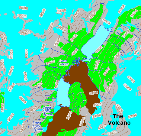
English: Topographic map of the Lava Forks Provincial Park area in northwestern British Columbia, Canada. |
| Date | |
| Source | Own work based on topographic map found on the The Atlas of Canada website [1] |
| Author | Black Tusk |
Licensing
[edit]
| I, the copyright holder of this work, release this work into the public domain. This applies worldwide. In some countries this may not be legally possible; if so: I grant anyone the right to use this work for any purpose, without any conditions, unless such conditions are required by law. |
File history
Click on a date/time to view the file as it appeared at that time.
| Date/Time | Thumbnail | Dimensions | User | Comment | |
|---|---|---|---|---|---|
| current | 03:33, 22 June 2010 | | 467 × 450 (103 KB) | Black Tusk (talk | contribs) | {{Information |Description={{en|1=Topographic map of the Lava Forks Provincial Park area in northwestern British Columbia, Canada.}} |Source={{own}} based on topographic map found on the The Atlas of Canada website [http://atlas.nrcan.gc.ca/site/english/m |
You cannot overwrite this file.
File usage on Commons
There are no pages that use this file.
File usage on other wikis
The following other wikis use this file:
- Usage on en.wikipedia.org
- Usage on es.wikipedia.org
- Usage on ja.wikipedia.org