File:Leśnica (gmina) location map.png

Original file (761 × 806 pixels, file size: 192 KB, MIME type: image/png)
Captions
Captions
Summary[edit]
_location_map.png&action=edit§ion=1)
| Description |
English: Location map |
| Date | |
| Source | Own work |
| Author | Smat |
| Description |
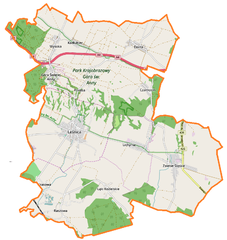
Polski: Mapa gminy Leśnica, Polska
English: Map of Leśnica (gmina), Poland |
|||||||||
| Date | ||||||||||
| Source | You may find a page on the OpenStreetMap wiki page for Leśnica (gmina) | |||||||||
| Creator |
OpenStreetMap contributors OpenStreetMap contributors |
|||||||||
| Permission (Reusing this file) |
OpenStreetMap data is available under the Open Database License (details). Map tiles are licensed under the Creative Commons Attribution-ShareAlike 2.0 license (CC-BY-SA 2.0).
This file is licensed under the Creative Commons Attribution-Share Alike 2.0 Generic license.
|
|||||||||
| Geotemporal data | ||||||||||
| Bounding box |
|
|||||||||
| Georeferencing | If inappropriate please set warp_status = skip to hide. | |||||||||
Licensing[edit]
_location_map.png&action=edit§ion=2)
| This work contains information from OpenStreetMap, which is made available under the Open Database License (ODbL).
The ODbL does not require any particular license for maps produced from ODbL data. Prior to 1 August 2020, map tiles produced by the OpenStreetMap Foundation were licensed under the CC-BY-SA-2.0 license. Maps produced by other people may be subject to other licences. |
File history
Click on a date/time to view the file as it appeared at that time.
| Date/Time | Thumbnail | Dimensions | User | Comment | |
|---|---|---|---|---|---|
| current | 10:01, 6 March 2017 | | 761 × 806 (192 KB) | Smat (talk | contribs) | User created page with UploadWizard |
You cannot overwrite this file.
File usage on Commons
There are no pages that use this file.
File usage on other wikis
The following other wikis use this file:
- Usage on cs.wikipedia.org
- Usage on fi.wikipedia.org
- Usage on pl.wikipedia.org
- Łąki Kozielskie
- Leśnica (gmina)
- Czarnocin (województwo opolskie)
- Dolna (województwo opolskie)
- Raszowa (powiat strzelecki)
- Krasowa (powiat strzelecki)
- Kadłubiec
- Lichynia
- Poręba (gmina Leśnica)
- Wysoka (powiat strzelecki)
- Zalesie Śląskie
- Góra Świętej Anny (województwo opolskie)
- Leśnica (miasto)
- Popice (Zalesie Śląskie)
- Granica (Lichynia)
- Cmentarz żydowski w Leśnicy
- Rezerwat przyrody Grafik
- Sanktuarium św. Anny na Górze św. Anny
- Rezerwat przyrody Biesiec
- Rezerwat przyrody Góra Św. Anny
- Leśnica (stacja kolejowa)
- Raszowa (przystanek kolejowy)
- Kurzawka (Raszowa)
- Rokicie (Raszowa)
- Zalesie Śląskie (stacja kolejowa)
- Łąki Kozielskie (stacja kolejowa)
- Parafia Trójcy Świętej w Leśnicy
- Parafia św. Anny na Górze Świętej Anny
- Muzeum Czynu Powstańczego w Górze Świętej Anny
- Kalwaria na Górze Świętej Anny
- Moduł:Mapa/dane/Leśnica (województwo opolskie)
- Kościół Trójcy Świętej w Leśnicy
- Kościół Zwiastowania Najświętszej Maryi Panny w Leśnicy
- Moduł:Mapa/dane/Leśnica (gmina)
- Parafia Wszystkich Świętych w Raszowej
- Parafia św. Floriana w Wysokiej
- Parafia św. Jadwigi Śląskiej w Zalesiu Śląskim
- Kapliczka Trzech Braci
- Parafia Świętych Apostołów Piotra i Pawła w Dolnej
- Usage on pl.wikibooks.org
_location_map.png&oldid=607600525)