File:Le Mont-Perdu vu de Tuquerouye, octobre 1892.jpg
Le_Mont-Perdu_vu_de_Tuquerouye,_octobre_1892.jpg (589 × 431 pixels, file size: 63 KB, MIME type: image/jpeg)
Captions
Captions
Summary
[edit]
| Description |
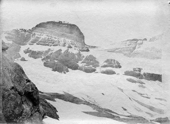
Fonds Trutat - Photographie ancienne Cote : TRU C 551 Localisation : Fonds ancien (S 30) Original non communicable Titre : Le Mont-Perdu vu de Tuquerouye, octobre 1892 Auteur : Trutat, Eugène Rôle de l’auteur : Photographe Lieu de création : Tuquerouye (Hautes-Pyrénées) Date de création : 1892 Mesures : : 9 x 12 cm Observations : Notes de la main de E. Trutat : "hémisph. Darlot f. 11, papier en rouleau Eastman?" Mot(s)-clé(s) : -- Montagne -- Vallée -- Pierre -- Lac -- Eau -- Neige -- Automne -- Mont-Perdu (Hautes-Pyrénées) -- Tuquerouye (Hautes-Pyrénées) -- Midi-Pyrénées (France) -- Pyrénées (France) -- Tuquerouye, Refuge de (France) -- 19e siècle, 4e quart Médium : Photographies -- Négatifs sur papier -- Noir et blanc -- Eastman -- Paysages Bibliothèque de Toulouse. Domaine public |
| Date | |
| Source | Le Mont-Perdu vu de Tuquerouye, octobre 1892 |
| Author | Original by Eugène Trutat (Born in 1840 - Dead in 1910) - Scan on Flickr by Bibliothèque de Toulouse |
| Permission (Reusing this file) |
Original picture (photo on glass) is in the public domain because its author died more than 70 years ago. The owner of the original picture (bibliothèque de Toulouse) made a scan and released it on Flickr with the mention "no known copyright restrictions": «Bibliothèque de Toulouse is a member of The Commons on Flickr. Bibliothèque de Toulouse images that are part of The Commons are marked as "no known copyright restrictions," indicating that the Library is unaware of any current copyright restrictions on the works so designated, either because the term of copyright may have expired without being renewed or because no evidence has been found that copyright restrictions apply» (source) |
| Camera location | | View this and other nearby images on: OpenStreetMap |
|---|
Licensing
[edit]
|
This work is in the public domain in its country of origin and other countries and areas where the copyright term is the author's life plus 70 years or fewer. | |
| This file has been identified as being free of known restrictions under copyright law, including all related and neighboring rights. | |
| This image, originally posted to Flickr, was reviewed on 29 September 2008 by the administrator or reviewer Guérin Nicolas, who confirmed that it was available on Flickr under the stated license on that date. |
File history
Click on a date/time to view the file as it appeared at that time.
| Date/Time | Thumbnail | Dimensions | User | Comment | |
|---|---|---|---|---|---|
| current | 07:49, 29 September 2008 | | 589 × 431 (63 KB) | Guérin Nicolas (talk | contribs) | {{Information |Description= Fonds Trutat - Photographie ancienne '''Cote :''' TRU C 551 '''Localisation :''' Fonds ancien (S 30) Original non communicable '''Titre :''' Le Mont-Perdu vu de Tuquerouye, octobre 1892 '''Auteur :''' Trutat, Eugène '''Rô |
You cannot overwrite this file.
File usage on Commons
There are no pages that use this file.
File usage on other wikis
The following other wikis use this file:
- Usage on es.wikipedia.org