File:League of Nations Anachronous Map-ar.PNG
Jump to navigation
Jump to search

Size of this preview: 800 × 509 pixels. Other resolutions: 320 × 204 pixels | 640 × 407 pixels | 1,024 × 651 pixels | 1,357 × 863 pixels.
Original file (1,357 × 863 pixels, file size: 83 KB, MIME type: image/png)
Captions
Captions
Add a one-line explanation of what this file represents
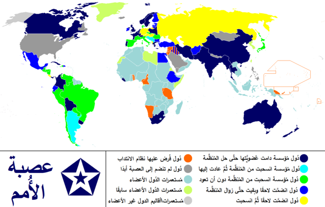
| Description | Anachronous map of the world between 1920 and 1945 which shows the The League of Nations and the world. / Carte du monde entre 1920 et 1945 montrant la place de la Société des Nations |
| Date | (UTC) |
| Source | |
| Author |
|
| This is a retouched picture, which means that it has been digitally altered from its original version. Modifications: translated to arabic. The original can be viewed here: League of Nations Anachronous Map.PNG:
|
I, the copyright holder of this work, hereby publish it under the following licenses:
| This file is licensed under the Creative Commons Attribution-Share Alike 3.0 Unported license. Subject to disclaimers. | ||
| ||
| This licensing tag was added to this file as part of the GFDL licensing update. |

|
Permission is granted to copy, distribute and/or modify this document under the terms of the GNU Free Documentation License, Version 1.2 or any later version published by the Free Software Foundation; with no Invariant Sections, no Front-Cover Texts, and no Back-Cover Texts. A copy of the license is included in the section entitled GNU Free Documentation License. Subject to disclaimers. |
You may select the license of your choice.
Original upload log
[edit]
This image is a derivative work of the following images:
- File:League_of_Nations_Anachronous_Map.PNG licensed with Cc-by-sa-3.0-migrated-with-disclaimers, GFDL-en
- 2011-01-14T09:31:21Z Elmor 1357x863 (55888 Bytes) minor text corrections
- 2011-01-12T08:47:35Z Elmor 1357x863 (55972 Bytes) corrected Japan-Soviet border
- 2009-10-09T18:43:30Z 23prootie 1357x863 (204627 Bytes) redo
- 2009-10-09T18:42:59Z 23prootie 1357x863 (204627 Bytes) redo
- 2009-10-09T18:40:24Z 23prootie 1357x863 (188367 Bytes) Reverted to version as of 16:17, 16 March 2009
- 2009-10-09T18:39:47Z 23prootie 800x509 (59856 Bytes) Philippines was semi-independent
- 2009-10-09T18:36:57Z 23prootie 800x509 (59847 Bytes) Change the philippines
- 2009-03-16T16:17:28Z Andrew Hampe 1357x863 (188367 Bytes) Reverted to version as of 10:36, 23 January 2009; Newer versions are of worse quality
- 2009-02-05T05:21:57Z 23prootie 1357x863 (204627 Bytes)
- 2009-02-05T04:14:48Z 23prootie 1357x863 (204627 Bytes)
- 2009-01-23T10:36:07Z Cognatus 1357x863 (188367 Bytes) {{retouched|fixed typos in legend... No [[sweat of the brow]] here.}}
- 2009-01-12T20:28:40Z Fluteflute 1357x863 (26511 Bytes) transparent background and optipng
- 2008-09-06T19:59:13Z Canuckguy 1357x863 (47743 Bytes) {{Information |Description= |Source= |Date= |Author= |Permission= |other_versions= }}
- 2008-09-03T05:09:01Z PhiLiP 1357x863 (48819 Bytes) According to [[:Image:LA2-NSRW-1-0148.jpg|a map of Republic of China]] published in 1914, Tibet and Mongolia were belong to China at that time.
- 2008-04-23T15:30:25Z Haukurth 1357x863 (46012 Bytes) Iceland was not a colony, it just wasn't a member. It chose not to join even though that League confirmed that it could.
- 2007-11-15T03:33:16Z Kelvinc 1357x863 (48959 Bytes) Korea and Taiwan re-coloured as colony of left member (Japan)
- 2007-08-04T18:05:57Z Sylfide 1357x863 (71787 Bytes) {{Information |Description=Anachronous map of the world between 1920-1944 which shows the The League of Nations and the world. / ''Carte du monde entre 1924 et 1944 montrant la place de la Société des Nations'' |Source=:en:
Uploaded with derivativeFX
File history
Click on a date/time to view the file as it appeared at that time.
| Date/Time | Thumbnail | Dimensions | User | Comment | |
|---|---|---|---|---|---|
| current | 16:21, 30 March 2020 | | 1,357 × 863 (83 KB) | باسم (talk | contribs) | updated version |
| 18:23, 9 July 2011 |  | 800 × 509 (102 KB) | باسم (talk | contribs) | {{Information |Description=Anachronous map of the world between 1920 and 1945 which shows the The League of Nations and the world. / ''Carte du monde entre 1920 et 1945 montrant la place de la Société des Nations'' |Source=*[[:File:League_of_Nations_Ana |
You cannot overwrite this file.
File usage on Commons
The following 2 pages use this file:
File usage on other wikis
The following other wikis use this file:
- Usage on ar.wikipedia.org
- Usage on arz.wikipedia.org