File:Lewis overthrust fault nh10f.jpg
پروندهٔ اصلی (۱٬۴۰۰ × ۸۷۰ پیکسل، اندازهٔ پرونده: ۷۱ کیلوبایت، نوع MIME پرونده: image/jpeg)
گزینهها
عنوان
| توضیح |
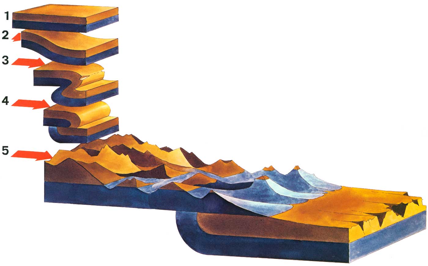
schematic illustration of the Lewis overthrust fault in northern Montana, USA and Southern Alberta, Canada. The fault can be seen best in Glacier National Park, USA and Waterton Lakes National Park, Canada. original caption: Overthrust Mountains 1 A hypothetical block of the Earth's crust in the region of Glacier National Park as it existed more than 60 million years ago. The two layers shown actually represent many strata of sedimentary rocks. 2 Lateral pressure begins to force the rock layers to buckle. 3 A large fold has been created, forcing the rock strata to double over and overturning some layers. A break, or fault, is forming at the plane of greatest stress. 4 The break has been completed and the strata west of the fault have slid eastward, up and over the rocks east of the fault. 5 The Glacier landscape today. Throughout the millions of years during which the folding, faulting, and overthrusting have been taking place, the process of erosion has continued; a thousand meters of stratified rocks have been worn away, so that only a remnant of the overthrust layers can be seen today. Because Glacier's eastern slope represents the eroded face of the overthrust block, the mountain range rises precipitously from the prairie, with no foothills breaking the abrupt transition from open prairie to mountain valley. |
|||
| تاریخ | ||||
| منبع | National Park Service http://www.nps.gov/history/history/online_books/natural/10/images/nh10f.jpg - used in the online edition of the book "MANY-STORIED MOUNTAINS - The Life of Glacier National Park" by Greg Beaumont, first published 1978 and online at http://www.nps.gov/history/history/online_books/natural/10/nh10b1.htm | |||
| پدیدآور | Greg Beaumont, National Park Service | |||
| اجازهنامه (استفادهٔ مجدد از این پرونده) |
|
تاریخچهٔ پرونده
روی تاریخ/زمانها کلیک کنید تا نسخهٔ مربوط به آن هنگام را ببینید.
| تاریخ/زمان | بندانگشتی | ابعاد | کاربر | توضیح | |
|---|---|---|---|---|---|
| کنونی | ۹ مارس ۲۰۰۹، ساعت ۲۱:۵۸ | | ۱٬۴۰۰ در ۸۷۰ (۷۱ کیلوبایت) | H-stt (بحث | مشارکتها) | {{Information |Description= schematic illustration of the Lewis overthrust fault in northern Montana, USA and Southern Alberta, Canada. The fault can be seen best in Glacier National Park, USA and Waterton Lakes National Park, Canada. original caption: O |
شما نمیتوانید این پرونده را رونویسی کنید.
کاربرد پرونده
صفحهٔ زیر از این تصویر استفاده میکند:
کاربرد سراسری پرونده
ویکیهای دیگر زیر از این پرونده استفاده میکنند:
- کاربرد در bn.wikipedia.org
- کاربرد در de.wikipedia.org
- کاربرد در en.wikipedia.org
- کاربرد در fa.wikipedia.org
- کاربرد در hi.wikipedia.org
- کاربرد در ta.wikipedia.org
- کاربرد در te.wikipedia.org
- کاربرد در uk.wikipedia.org
- کاربرد در zh.wikipedia.org