File:Lexington Concord Siege of Boston.jpg
ナビゲーションに移動
検索に移動
このプレビューのサイズ: 778 × 600 ピクセル。 その他の解像度: 311 × 240 ピクセル | 623 × 480 ピクセル | 996 × 768 ピクセル | 1,280 × 987 ピクセル | 2,560 × 1,974 ピクセル | 3,211 × 2,476 ピクセル。
元のファイル (3,211 × 2,476 ピクセル、ファイルサイズ: 1.55メガバイト、MIME タイプ: image/jpeg)
キャプション
キャプション
このファイルの内容を1行で記述してください
概要
[編集]
| 解説 |
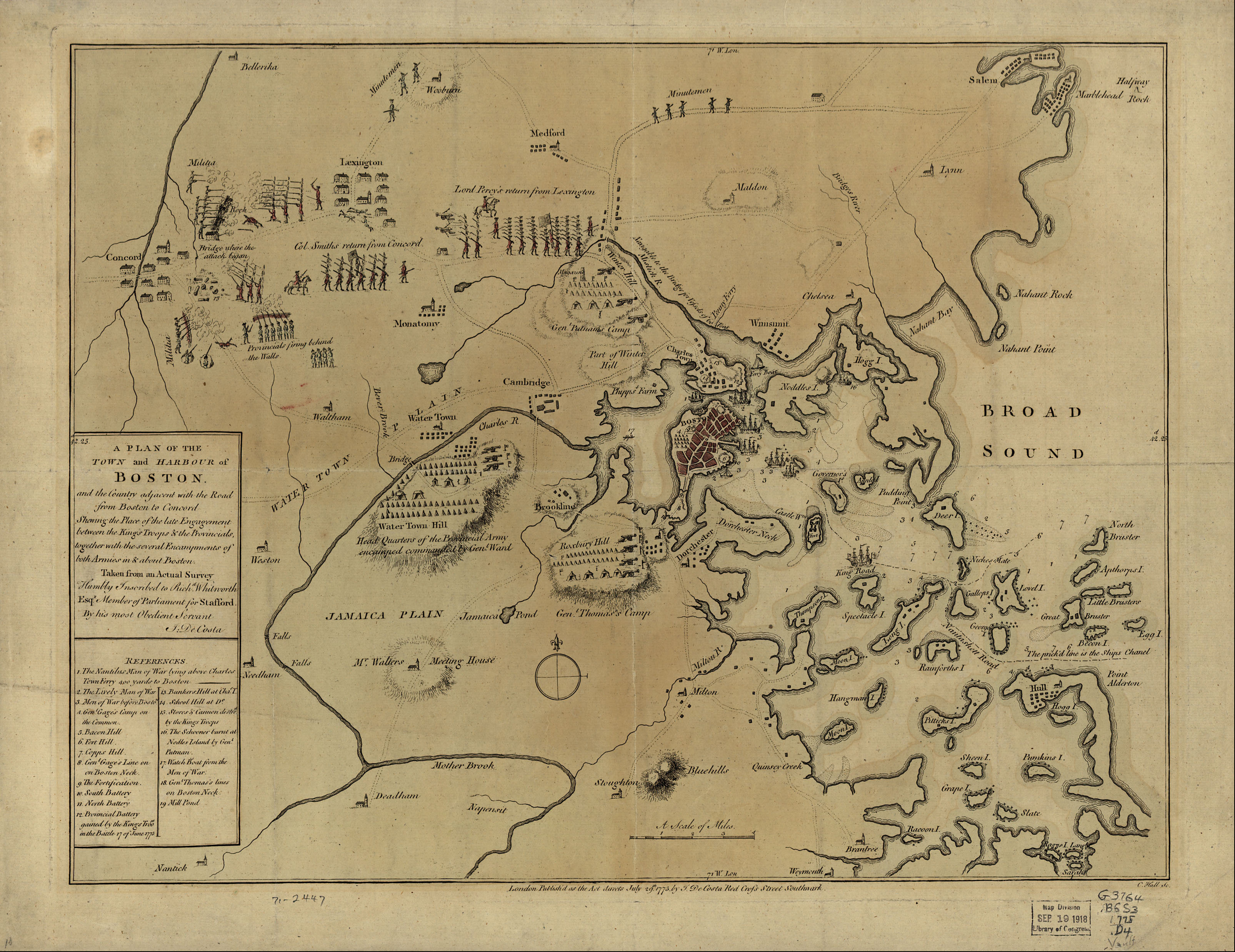
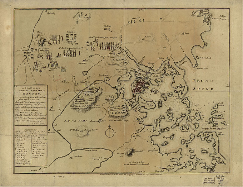
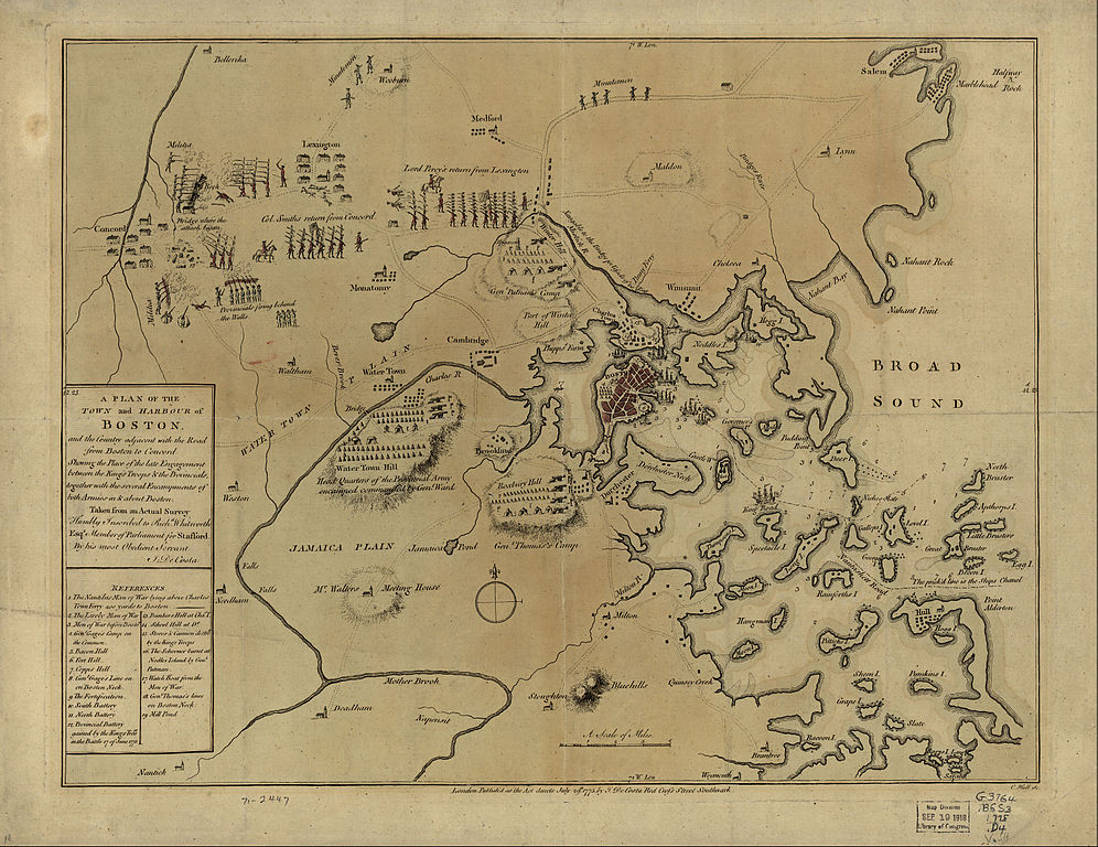
English: A mostly accurate hand-colored map depicting the 1775 Battles of Lexington and Concord and the Siege of Boston |
| 日付 | |
| 原典 |
From the Library of Congress American Memory. |
| 作者 | J. DeCosta |
| その他のバージョン |
 |
Large text box
[編集]
a PLAN of the
TOWN and HARBOUR of
Boston.
and the Country adjacent with the Road
from Boston to Concord
Shewing the Place of the late Engagement
between the King's Troops & the Provincials,
together with the several Encampments of
both Armies in & about Boston.
Taken from an Actual Survey
Humbly Inscribed to Rich d. Whitworth
Esqr. Member of Parliament for Stafford
Legend
[編集]
References.
- The Nautilus Man of War lying above Charles
- Town Ferry 400 yards to Boston
- The Lively Man of War
- Men of War before Boston.
- Gen l. Gage's Camp on
- the Common.
- Bacon Hill [i.e. Beacon Hill]
- Fort Hill.
- Copps Hill.
- Gen l. Gage's Line on
- on Boston Neck.
- The Fortification.
- South Battery
- North Battery
- Provincial Battery
- gained by the King's Troo ps
- in the Battle 17 of June 1775
- Bunkers Hill at Cha s. T.
- School Hill at D o.
- Stores & Cannon destro d
- by the King's Troops
- The Schooner burnt at
- Nodles Island by Gen l.
- Putman
- Watch Boat from the Men of War.
- Gen l. Thomas's lines
- on Boston Neck
- Mill Pond
Text along the bottom
[編集]
- London Publish'd as the Act directs July 29th. 1775 by J. De Costa Red Croſs Street Southwark.

|
この地図はアメリカ合衆国議会図書館の地理・地図部門から入手できます。デジタル識別子は g3764b.ar090000 です。
このタグは、添付された著作物の著作権状況を示すものではありません。通常の著作権タグも必要です。Commons:ライセンシングもご覧ください。
|
|
この著作物は、著作権の保護期間が著作者の死後100年以下である国・地域においてパブリックドメインの状態にあります。 | |
| このファイルは著作権法の既知の制約(隣接権や関連する権利を含む)から自由であると特定されています。 | |
ファイルの履歴
過去の版のファイルを表示するには、その版の日時をクリックしてください。
| 日付と時刻 | サムネイル | 寸法 | 利用者 | コメント | |
|---|---|---|---|---|---|
| 現在の版 | 2005年5月10日 (火) 07:30 | | 3,211 × 2,476 (1.55メガバイト) | Flying Jazz (トーク | 投稿記録) | "A plan of the town and harbour of Boston and the country adjacent with the road from Boston to Concord, shewing the place of the late engagement between the King's troops & the provincials, together with the several encampments of both armies in & about |
このファイルは上書きできません。
ファイルの使用状況
以下の 5 ページがこのファイルを使用しています:
グローバルなファイル使用状況
以下に挙げる他のウィキがこの画像を使っています:
- azb.wikipedia.org での使用状況
- az.wikipedia.org での使用状況
- ca.wikipedia.org での使用状況
- cs.wikipedia.org での使用状況
- da.wikipedia.org での使用状況
- de.wikipedia.org での使用状況
- en.wikipedia.org での使用状況
- en.wikivoyage.org での使用状況
- es.wikipedia.org での使用状況
- fi.wikipedia.org での使用状況
- fo.wikipedia.org での使用状況
- fr.wikipedia.org での使用状況
- fr.wikiversity.org での使用状況
- it.wikipedia.org での使用状況
- it.wikivoyage.org での使用状況
- ja.wikipedia.org での使用状況
- no.wikipedia.org での使用状況
- pl.wikipedia.org での使用状況
- ro.wikipedia.org での使用状況
- sr.wikipedia.org での使用状況
- th.wikipedia.org での使用状況
- www.wikidata.org での使用状況
- zh.wikipedia.org での使用状況
メタデータ
カテゴリ:
- Old maps of the American Revolution
- Battles of Lexington and Concord
- Military maps
- Maps of sieges
- Fort Hill (Boston)
- South Battery (Boston)
- Maps in the Library of Congress
- Maps of the Battle of Bunker Hill
- Siege of Boston
- 1775 maps of Boston
- 1775 in Boston
- Maps of the Boston Campaign
- Massachusetts in the American Revolution