File:Liberty Cab Company and WEBR radio studios, Kenmore Avenue, Buffalo, New York - 20220910.jpg
Jump to navigation
Jump to search

Size of this preview: 800 × 480 pixels. Other resolutions: 320 × 192 pixels | 1,024 × 614 pixels | 1,280 × 768 pixels | 3,029 × 1,817 pixels.
Original file (3,029 × 1,817 pixels, file size: 1.29 MB, MIME type: image/jpeg)
Captions
Captions
Add a one-line explanation of what this file represents
Summary[edit]
| Description |
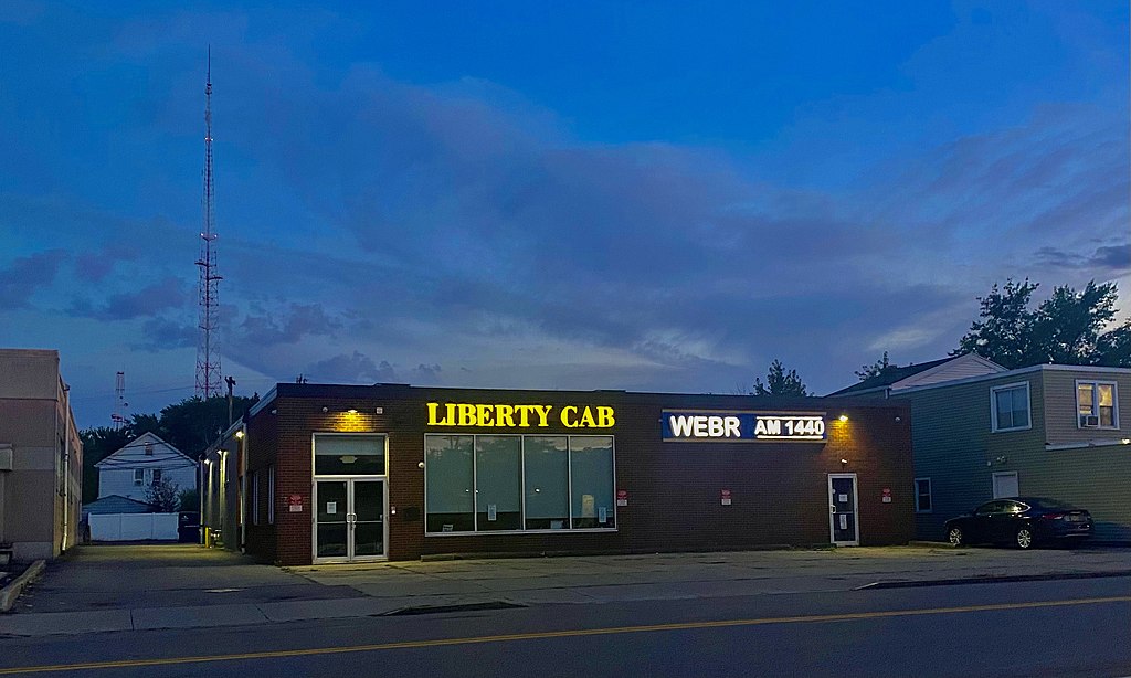
English: As seen on a September 2022 evening, the building at 1580 Kenmore Avenue in Buffalo, New York does double duty as headquarters of the Liberty Cab Company and the studios of radio station WEBR, both of which are owned by local businessman William Yuhnke. This nondescript single-story brick building was constructed about 1960 as a showroom for Dusing & Hunt, a manufacturer of fireproof metal doors, and was purchased by Liberty in 2015 to house its taxi fleet. As for the radio station, its history is one of the most storied in the Niagara Frontier: based in Niagara Falls with the call letters WJJL for the majority of its existence, it boasted a floridly diverse schedule locally programmed for Niagara Falls, with a rich roster of on-air talent many of whom would go on to illustrious careers elsewhere in radio, an active news operation covering the city and its vicinity in Niagara County, as well as specialty shows for the local Hispanic and Italian communities. Yuhnke bought the station from its previous owners in 2020, changed its call letters to WEBR (which local listeners remember was for many years the callsign for AM 970, one of Buffalo's earliest radio stations), moved its studios to the present location (the transmitter building, along with the station's official FCC registration, remain in Niagara Falls), and curates a playlist focused on soft oldies, jazz standards, and modern adult contemporary. |
| Date | |
| Source | Own work |
| Author | Andre Carrotflower |
| Camera location | | View this and other nearby images on: OpenStreetMap |
|---|
Licensing[edit]
I, the copyright holder of this work, hereby publish it under the following license:
This file is licensed under the Creative Commons Attribution-Share Alike 4.0 International license.
- You are free:
- to share – to copy, distribute and transmit the work
- to remix – to adapt the work
- Under the following conditions:
- attribution – You must give appropriate credit, provide a link to the license, and indicate if changes were made. You may do so in any reasonable manner, but not in any way that suggests the licensor endorses you or your use.
- share alike – If you remix, transform, or build upon the material, you must distribute your contributions under the same or compatible license as the original.
File history
Click on a date/time to view the file as it appeared at that time.
| Date/Time | Thumbnail | Dimensions | User | Comment | |
|---|---|---|---|---|---|
| current | 20:17, 13 September 2022 | | 3,029 × 1,817 (1.29 MB) | Andre Carrotflower (talk | contribs) | Uploaded own work with UploadWizard |
You cannot overwrite this file.
File usage on Commons
There are no pages that use this file.
File usage on other wikis
The following other wikis use this file:
- Usage on en.wikipedia.org