File:Libya (Tripolitania) in 1818 Pinkerton Map of Northern Africa and the Mediterranean - Geographicus - NorthernAfrica-pinkerton-1818 (cropped).jpg

Πρωτότυπο αρχείο (2.229 × 2.248 εικονοστοιχεία, μέγεθος αρχείου: 1,13 MB, τύπος MIME: image/jpeg)
Λεζάντες
Λεζάντες
| John Pinkerton: Northern Africa.
( |
|||||||||||||||||||||
|---|---|---|---|---|---|---|---|---|---|---|---|---|---|---|---|---|---|---|---|---|---|
| Καλλιτέχνης |
|
||||||||||||||||||||
| Τίτλος |
Northern Africa. |
||||||||||||||||||||
| Περιγραφή |
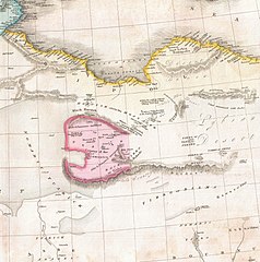
English: This fascinating hand colored 1818 map by Edinburgh cartographer John Pinkerton depicts northern Africa. Covers from Morocco to Siwa (Siwah) Oasis in the Libyan Desert. Focuses Morocco and the Mediterranean regions of Fez, Algeria, Tunisia and Tripoli. Also shows the Kingdom of Fezzan. Though mostly desert Fezzan has numerous oaises and supported a relatively large population. This desert kingdom was a critical stopping point for trade caravans crossing the Sahara since antiquity. Drawn by L. Herbert and engraved by Samuel Neele under the direction of John Pinkerton. This map comes from the scarce American edition of Pinkerton’s Modern Atlas, published by Thomas Dobson & Co. of Philadelphia in 1818. |
||||||||||||||||||||
| Ημερομηνία | 1818 (undated) | ||||||||||||||||||||
| Διαστάσεις | ύψος: 20,5 ίντσες (52 cm)• πλάτος: 28 ίντσες (71,1 cm) | ||||||||||||||||||||
| Αριθμός καταχώρησης |
Geographicus link: NorthernAfrica-pinkerton-1818 |
||||||||||||||||||||
| Πηγή/φωτογράφος |
Pinkerton, J., A Modern Atlas, from the Lates and Best Authorities, Exhibiting the Various Divisions of the World with its chief Empires, Kingdoms, and States; in Sixty Maps, carefully reduced from the Larges and Most Authentic Sources. 1818, Philadelphia, Thomas Dobson Edition.
|
||||||||||||||||||||
| Άδεια (Επαναχρησιμοποίηση αυτού του αρχείου) |
|
||||||||||||||||||||
| άλλες εκδόσεις | |||||||||||||||||||||


Ιστορικό αρχείου
Πατήστε σε μια ημερομηνία/ώρα για να δείτε το αρχείο όπως εμφανιζόταν εκείνη την χρονική στιγμή.
| Ημερομηνία/Ώρα | Μικρογραφία | Διαστάσεις | Χρήστης | Σχόλιο | |
|---|---|---|---|---|---|
| τρέχον | 09:33, 27 Σεπτεμβρίου 2022 | | 2.229 × 2.248 (1,13 MB) | Onceinawhile (συζήτηση | Συνεισφορά) | File:1818 Pinkerton Map of Northern Africa and the Mediterranean - Geographicus - NorthernAfrica-pinkerton-1818.jpg cropped 55 % horizontally, 38 % vertically using CropTool with precise mode. |
Δεν μπορείτε να αντικαταστήσετε αυτό το αρχείο.
Χρήση αρχείου
Οι ακόλουθες 2 σελίδες χρησιμοποιούν προς αυτό το αρχείο:
_in_1818_Pinkerton_Map_of_Northern_Africa_and_the_Mediterranean_-_Geographicus_-_NorthernAfrica-pinkerton-1818_(cropped).jpg)
Καθολική χρήση αρχείου
Τα ακόλουθα άλλα wiki χρησιμοποιούν αυτό το αρχείο:
- Χρήση σε el.wikipedia.org
- Χρήση σε en.wikipedia.org
- Χρήση σε mt.wikipedia.org
- Χρήση σε sl.wikipedia.org
_in_1818_Pinkerton_Map_of_Northern_Africa_and_the_Mediterranean_-_Geographicus_-_NorthernAfrica-pinkerton-1818_(cropped).jpg&oldid=693203734)