File:Lindner Staffelsee-Karte 1921 mit Erläuterungen.jpg
Jump to navigation
Jump to search
Size of this preview: 707 × 600 pixels. Other resolutions: 283 × 240 pixels | 566 × 480 pixels | 905 × 768 pixels | 1,207 × 1,024 pixels | 2,414 × 2,048 pixels | 4,418 × 3,749 pixels.
Original file (4,418 × 3,749 pixels, file size: 1.94 MB, MIME type: image/jpeg)
Captions
Captions
Add a one-line explanation of what this file represents
Summary[edit]
| Description |
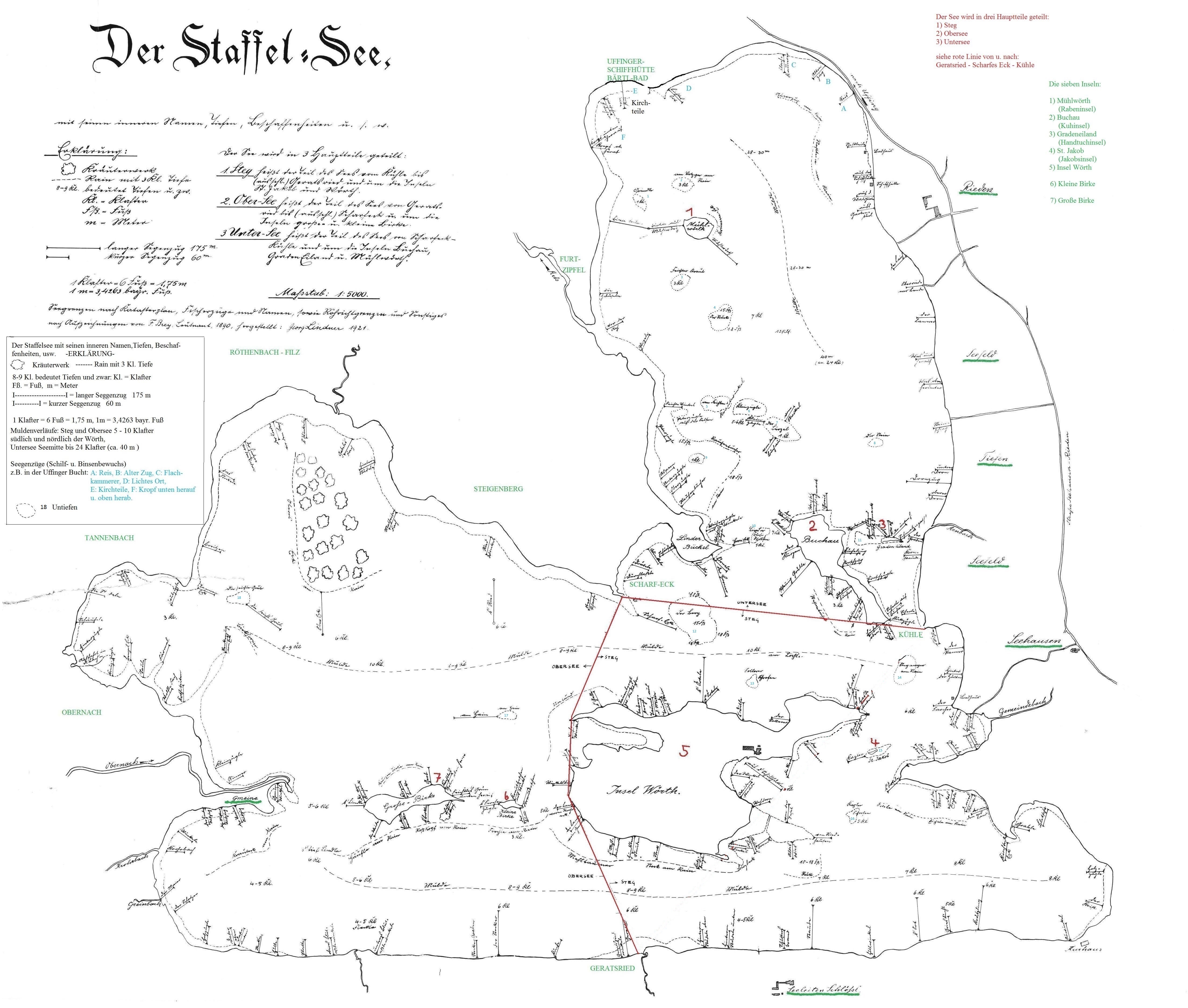
Deutsch: Karte des Staffelsees nach Aufzeichnungen von F. Brey, Leutnant, 1890, hergestellt: Georg Lindner, 1921 Verzeichnete Untiefen (zumeist nicht existent): 1) Grundle 2) Am Votzger Rain 3) Feichter Kraut 4) Der Ruck 5) Am Feichten 6) Kleinzügle 7) Der Bürzel 8) Der Stein (Untiefe) 9) Ohne Namen 10) Linderbühl Schrofen 11) Grad Eiland (bei Insel) 12) Der Berg 13) Sollerer Schrofen 14) Steganger am Rain 15) St. Jakob (bei Insel) 16) Kugler Schrofen 17) Am Hain (Untiefe) 18) Die seichte Grub |
| Date | |
| Source | Scan des Originals im Archiv des Heimatmuseums Uffing. Eine nachbearbeitete Version ist veröffentlicht im Bürgerblatt für Uffing und Scheffau, 34/2014, Teil 1, S. 20–21. |
| Author | Georg Lindner (19. Dezember 1861 – 28. Juli 1941) |
| Other versions |
|


Licensing[edit]
|
This work is in the public domain in its country of origin and other countries and areas where the copyright term is the author's life plus 70 years or fewer. This work is in the public domain in the United States because it was published (or registered with the U.S. Copyright Office) before January 1, 1929. | |
| This file has been identified as being free of known restrictions under copyright law, including all related and neighboring rights. | |
File history
Click on a date/time to view the file as it appeared at that time.
| Date/Time | Thumbnail | Dimensions | User | Comment | |
|---|---|---|---|---|---|
| current | 14:11, 24 August 2021 | | 4,418 × 3,749 (1.94 MB) | Ratzer (talk | contribs) | Uploaded a work by kommt from kommt with UploadWizard |
You cannot overwrite this file.
File usage on Commons
The following 6 pages use this file:
File usage on other wikis
The following other wikis use this file:
- Usage on de.wikipedia.org