File:Linguistic and political map of Eastern Europe, Casimir Delamarre, 1868.jpg
跳至導覽
跳至搜尋

預覽大小:382 × 599 像素。 其他解析度:153 × 240 像素 | 306 × 480 像素 | 489 × 768 像素 | 652 × 1,024 像素 | 2,432 × 3,816 像素。
原始檔案 (2,432 × 3,816 像素,檔案大小:2.05 MB,MIME 類型:image/jpeg)
說明
說明
添加單行說明來描述出檔案所代表的內容
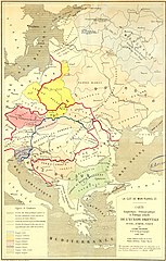
Linguistic, ethnographic, and political map of Eastern Europe by Casimir Delamarre, 1868
摘要
[編輯]
| 描述 |
English: Linguistic, ethnographic, and political map of Eastern Europe by Casimir Delamarre (fr:Théodore-Casimir Delamarre), 1868. Original title:
Українська: Мовна, етнографічна та політична мапа Східної Європи Казимира Делямара, 1868 рік
Français : Carte linguistique, ethnographique, et politique actuelle de l'Europe orientale, Russie, Autriche, Turquie / par Casimir Delamarre ; gravé chez Erhard. |
| 日期 | |
| 來源 | THE UNIVERSITY OF CHICAGO VISUAL RESOURCES CENTER |
| 作者 |
授權條款
[編輯]
|
本作品在其來源國以及其他版權期限是作者逝世後70年或以下的國家與地區屬於公有領域。 | |
| 此作品無已知的著作權限制,亦不受所有相關和鄰接的權利限制。 | |
檔案歷史
點選日期/時間以檢視該時間的檔案版本。
| 日期/時間 | 縮圖 | 尺寸 | 用戶 | 備註 | |
|---|---|---|---|---|---|
| 目前 | 2020年2月10日 (一) 20:02 | | 2,432 × 3,816(2.05 MB) | ZxcvU(對話 | 貢獻) | User created page with UploadWizard |
無法覆蓋此檔案。
檔案用途
全域檔案使用狀況
以下其他 wiki 使用了這個檔案:
- en.wikipedia.org 的使用狀況
- Ruthenia
- Ruthenians
- Ruthenian language
- Litvinism
- User:Falcaorib/Ukraine
- User:Falcaorib/Europe
- User:Falcaorib/Austria-Hungary
- User:Falcaorib/Czechoslovakia
- User:Falcaorib/Poland-Lithuania
- User:Falcaorib/Belarus
- User:Falcaorib/Balkans maps
- User:Falcaorib/Balkans ethnic maps
- User:Falcaorib/Serbia, Yugoslavia and Albania
- User:Falcaorib/Romania and Moldova
- User:Falcaorib/Bulgaria and North Macedonia
- User:Falcaorib/Turkey and Ottoman Empire
- es.wikipedia.org 的使用狀況
- fi.wikipedia.org 的使用狀況
- mk.wikipedia.org 的使用狀況
- ru.wikipedia.org 的使用狀況
- uk.wikipedia.org 的使用狀況
- zh.wikipedia.org 的使用狀況