File:Liniennetz Rostock Umgebung 2015.png
Jump to navigation
Jump to search

Size of this preview: 800 × 566 pixels. Other resolutions: 320 × 226 pixels | 640 × 453 pixels | 1,024 × 724 pixels | 1,280 × 905 pixels | 2,560 × 1,810 pixels | 6,182 × 4,371 pixels.
Original file (6,182 × 4,371 pixels, file size: 1.35 MB, MIME type: image/png)
Captions
Captions
Add a one-line explanation of what this file represents
| Description |
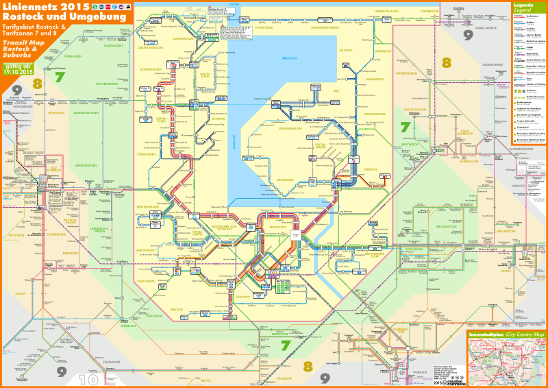
English: Transit map of Rostock and suburbs (2015-02-16)
Deutsch: Liniennetz Rostock und Umgebung (16. Februar 2015) |
| Source | Own work |
| Author | Lucas Weiss |
| Permission (Reusing this file) |
This file is licensed under the Creative Commons Attribution-Share Alike 4.0 International license.
|
| Other versions |
|


File history
Click on a date/time to view the file as it appeared at that time.
| Date/Time | Thumbnail | Dimensions | User | Comment | |
|---|---|---|---|---|---|
| current | 08:00, 20 October 2015 | | 6,182 × 4,371 (1.35 MB) | LuWe (talk | contribs) | construction works ended (26, 38, F1) |
| 15:53, 1 October 2015 |  | 6,182 × 4,371 (1.37 MB) | LuWe (talk | contribs) | construction works (S1, S2, S3, 38, F1); Markgrafenheide/Hohe Düne (202) | |
| 15:25, 28 August 2015 |  | 6,182 × 4,371 (1.37 MB) | LuWe (talk | contribs) | 1st correction 2015; rearrangements; city centre map added | |
| 06:53, 21 July 2015 |  | 6,234 × 4,408 (1.3 MB) | LuWe (talk | contribs) | construction works in Schmarl, Bad Doberan, Groß Stove, and Kritzmow; long-distance bus in Bad Doberan; adjustments in the legend | |
| 07:02, 29 June 2015 |  | 6,234 × 4,408 (1.29 MB) | LuWe (talk | contribs) | construction works in Biestow, Schmarl, and Groß Bölkow | |
| 15:49, 13 June 2015 |  | 6,234 × 4,408 (1.28 MB) | LuWe (talk | contribs) | construction works (lines 37, 38, F1); rearrangements and minor adjustments | |
| 14:27, 17 May 2015 |  | 6,234 × 4,408 (1.27 MB) | LuWe (talk | contribs) | {{Information |Description={{en|1=Transit map of Rostock and suburbs (2015-02-16)}} {{de|1=Liniennetz Rostock und Umgebung (16. Februar 2015)}} |Source={{own}} |Author=Lucas Weiss |Date= |Permission={{Cc-by-sa-4.0}} |other_versions=<galle... |
You cannot overwrite this file.
File usage on Commons
The following 15 pages use this file:
- User:Chumwa/OgreBot/Public transport information/2015 August 21-31
- User:Chumwa/OgreBot/Public transport information/2015 July 21-31
- User:Chumwa/OgreBot/Public transport information/2015 June 11-20
- User:Chumwa/OgreBot/Public transport information/2015 June 21-30
- User:Chumwa/OgreBot/Public transport information/2015 May 11-20
- User:Chumwa/OgreBot/Public transport information/2015 October 1-10
- User:Chumwa/OgreBot/Public transport information/2015 October 11-20
- User:Chumwa/OgreBot/Transport Maps/2015 August 21-31
- User:Chumwa/OgreBot/Transport Maps/2015 July 21-31
- User:Chumwa/OgreBot/Transport Maps/2015 June 11-20
- User:Chumwa/OgreBot/Transport Maps/2015 June 21-30
- User:Chumwa/OgreBot/Transport Maps/2015 May 11-20
- User:Chumwa/OgreBot/Transport Maps/2015 October 1-10
- User:Chumwa/OgreBot/Transport Maps/2015 October 11-20
- File:Liniennetz Rostock 2015.svg
File usage on other wikis
The following other wikis use this file:
- Usage on de.wikipedia.org