File:Link light rail geographic map.svg
跳转到导航
跳转到搜索

此SVG文件的PNG预览的大小:550 × 600像素。 其他分辨率:220 × 240像素 | 440 × 480像素 | 705 × 768像素 | 939 × 1,024像素 | 1,879 × 2,048像素 | 1,600 × 1,744像素。
原始文件 (SVG文件,尺寸为1,600 × 1,744像素,文件大小:597 KB)
说明
说明
添加一行文字以描述该文件所表现的内容
摘要
[编辑]

|
该图像需要长期保持更新。如果有需要请更新该图像。
|
| 描述 |
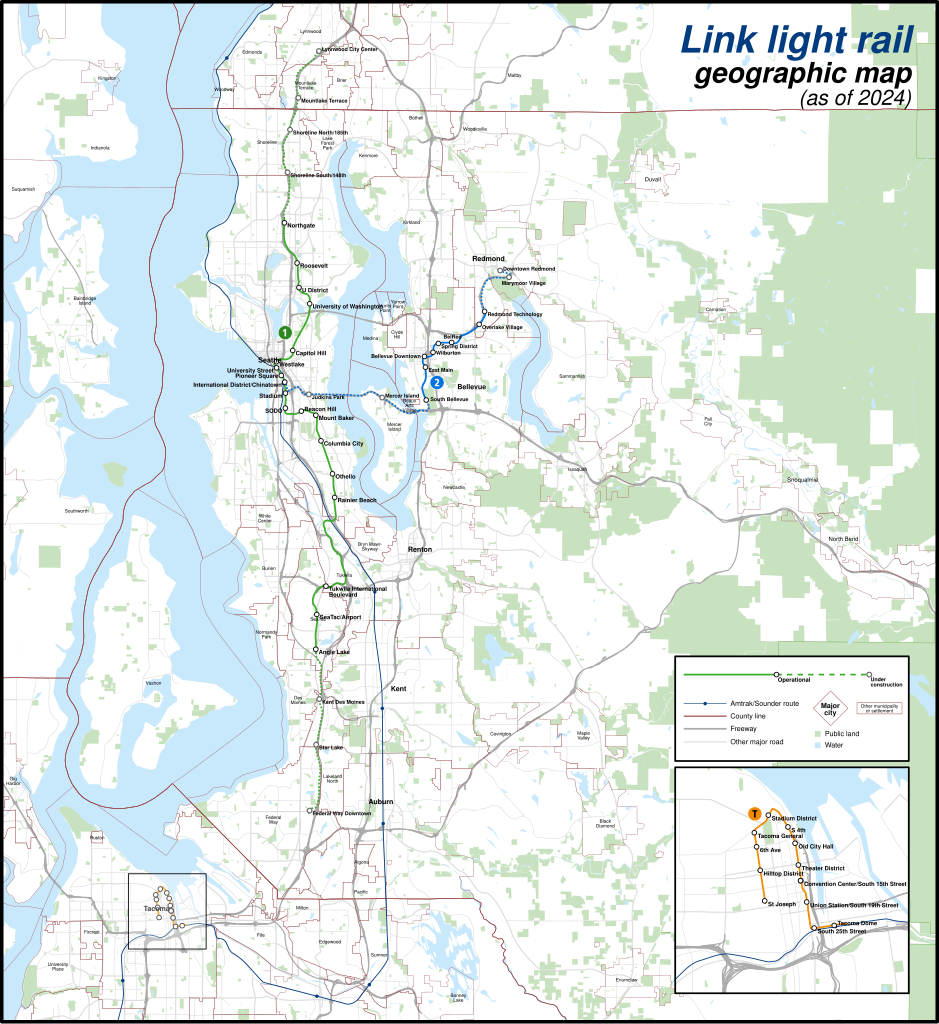
English: A geographically-accurate map of lines of the Link light rail, including parts under construction (dashed in map), overlayed on a basemap containing the Silver Line and commuter rail lines, municipalities, roads, water areas, area landmarks, and green spaces. Shapefiles from the United States Census Bureau, the U.S. Geological Survey (USGS) Gap Analysis Project (GAP), Sound Transit, and OpenStreetMap (© OpenStreetMap contributors), converted with Mapshaper and Inkscape (Mercator projection). |
| 日期 | |
| 来源 | 自己的作品 |
| 作者 | Twotwofourtysix |
许可协议
[编辑]
我,本作品著作权人,特此采用以下许可协议发表本作品:
本文件采用知识共享署名-相同方式共享 4.0 国际许可协议授权。
- 您可以自由地:
- 共享 – 复制、发行并传播本作品
- 修改 – 改编作品
- 惟须遵守下列条件:
- 署名 – 您必须对作品进行署名,提供授权条款的链接,并说明是否对原始内容进行了更改。您可以用任何合理的方式来署名,但不得以任何方式表明许可人认可您或您的使用。
- 相同方式共享 – 如果您再混合、转换或者基于本作品进行创作,您必须以与原先许可协议相同或相兼容的许可协议分发您贡献的作品。
文件历史
点击某个日期/时间查看对应时刻的文件。
| 日期/时间 | 缩略图 | 大小 | 用户 | 备注 | |
|---|---|---|---|---|---|
| 当前 | 2024年5月5日 (日) 02:49 | | 1,600 × 1,744(597 KB) | Twotwofourtysix(留言 | 贡献) | Update with opening of line section |
| 2024年5月4日 (六) 07:58 |  | 1,600 × 1,744(635 KB) | OrdinaryScarlett(留言 | 贡献) | Update date | |
| 2024年5月4日 (六) 07:01 |  | 1,600 × 1,744(673 KB) | SounderBruce(留言 | 贡献) | Remove CDP "boundaries" that change with every census; cleanup label placement on 2 Line | |
| 2024年5月1日 (三) 02:41 |  | 1,600 × 1,744(651 KB) | OrdinaryScarlett(留言 | 贡献) | Update 2 Line and Lynnwood and Federal Way Link Extension station names | |
| 2024年1月19日 (五) 20:05 |  | 1,600 × 1,744(690 KB) | SounderBruce(留言 | 贡献) | Removing most labels for CDPs, which are arbitrarily assigned by the Census Bureau and change frequently; boundaries should also be deleted at some point | |
| 2024年1月19日 (五) 14:18 |  | 1,600 × 1,744(650 KB) | Twotwofourtysix(留言 | 贡献) | Adds legend & title, adjusts colours | |
| 2024年1月18日 (四) 15:58 |  | 1,600 × 1,744(1.76 MB) | Twotwofourtysix(留言 | 贡献) | Uploaded own work with UploadWizard |
您不可以覆盖此文件。
文件用途
以下10个页面使用本文件:
- User:Chumwa/OgreBot/Public transport information/2024 January 11-20
- User:Chumwa/OgreBot/Public transport information/2024 May 1-10
- User:Chumwa/OgreBot/Transport Maps/2024 January 11-20
- User:Chumwa/OgreBot/Transport Maps/2024 May 1-10
- User:Chumwa/OgreBot/Travel and communication maps/2024 May 1-10
- User:GeorgR (de)/Rail Transport in the US/2024 January
- User:GeorgR (de)/Rail Transport in the US/2024 May
- User:Twotwofourtysix
- Commons:Graphic Lab/Map workshop/Archive/2024
- Category:Link light rail
全域文件用途
以下其他wiki使用此文件:
- ca.wikipedia.org上的用途
- cs.wikipedia.org上的用途
- de.wikipedia.org上的用途
- de.wikivoyage.org上的用途
- en.wikipedia.org上的用途
- es.wikipedia.org上的用途
- fa.wikipedia.org上的用途
- fr.wikipedia.org上的用途
- it.wikipedia.org上的用途
- mr.wikipedia.org上的用途
- uk.wikipedia.org上的用途
- www.wikidata.org上的用途
- zh.wikipedia.org上的用途