File:Litauisches Sprachgebiet (1876).JPG
Jump to navigation
Jump to search

Size of this preview: 763 × 600 pixels. Other resolutions: 306 × 240 pixels | 611 × 480 pixels | 977 × 768 pixels | 1,280 × 1,006 pixels | 2,560 × 2,012 pixels | 3,624 × 2,848 pixels.
Original file (3,624 × 2,848 pixels, file size: 1.87 MB, MIME type: image/jpeg)
Captions
Captions
Add a one-line explanation of what this file represents
Summary
[edit].JPG&action=edit§ion=1)
| Description |
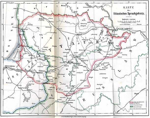
Беларуская (тарашкевіца): Мапа абшараў з часткова летувіскамоўным насельніцтвам, на якой Ковенская губэрня азначаецца Жамойцю Deutsch: Karte des littauischen Sprachgebietes |
| Date | |
| Source | Grammatik der littauischen Sprache von Dr. Friedrich Kurschat, Professor zu Königsberg i. Pr. 1876. |
| Author | own scan |
| Other versions |
.jpg) |
Licensing
[edit].JPG&action=edit§ion=2)
|
This work is in the public domain in its country of origin and other countries and areas where the copyright term is the author's life plus 70 years or fewer. This work is in the public domain in the United States because it was published (or registered with the U.S. Copyright Office) before January 1, 1929. | |
| This file has been identified as being free of known restrictions under copyright law, including all related and neighboring rights. | |
File history
Click on a date/time to view the file as it appeared at that time.
| Date/Time | Thumbnail | Dimensions | User | Comment | |
|---|---|---|---|---|---|
| current | 18:49, 7 November 2009 | | 3,624 × 2,848 (1.87 MB) | Alex:D (talk | contribs) | whitened |
| 20:11, 19 October 2008 |  | 3,624 × 2,848 (1.57 MB) | Olahus (talk | contribs) | {{Information |Description=Karte des littauischen Sprachgebietes |Source=Grammatik der littauischen Sprache von Dr. Friedrich Kurschat, Professor zu Königsberg i. Pr. |Date=1876 |Author=own scan |Permission= |other_versions= }} {{pd-old}} [[Category:Maps |
You cannot overwrite this file.
File usage on Commons
The following 2 pages use this file:
File usage on other wikis
The following other wikis use this file:
- Usage on en.wikipedia.org
- Usage on lt.wikipedia.org
- Usage on lt.wikibooks.org
- Usage on ro.wikipedia.org
- Usage on ru.wikipedia.org
.JPG&oldid=793907559)