File:Liverpool Bay.png
Przejdź do nawigacji
Przejdź do wyszukiwania

Rozmiar podglądu – 800 × 593 pikseli. Inne rozdzielczości: 320 × 237 pikseli | 640 × 474 pikseli | 1024 × 759 pikseli | 1278 × 947 pikseli.
Rozmiar pierwotny (1278 × 947 pikseli, rozmiar pliku: 1,84 MB, typ MIME: image/png)
Podpisy
Podpisy
Dodaj jednolinijkowe objaśnienie tego, co ten plik pokazuje
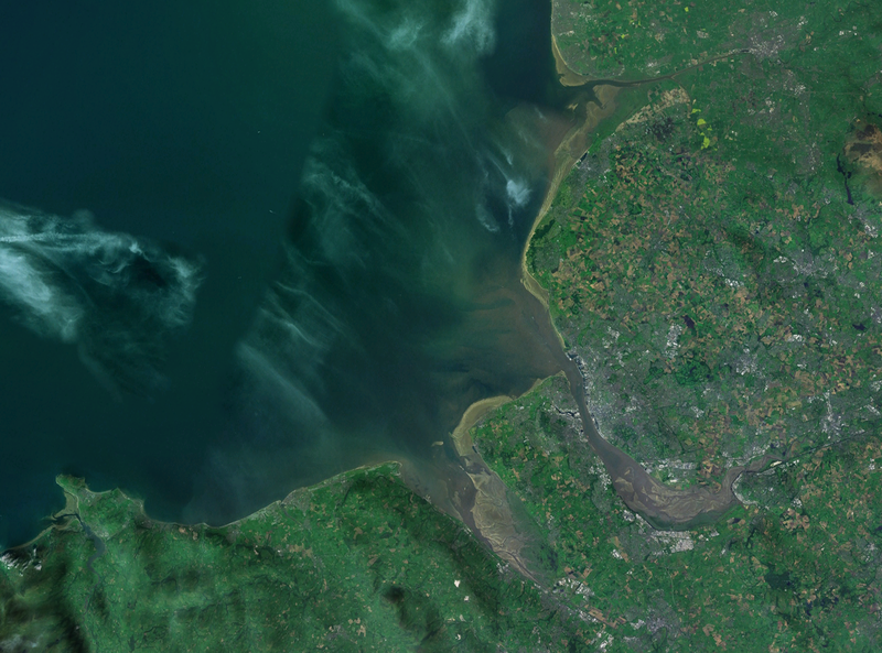
| Opis | A satellite photograph of Liverpool Bay, showing the West Lancashire Coastal Plain River Ribble at the top (north), the River Alt (hardly visble), River Mersey (centre) River Dee and the River Conwy in the south west. |
| Data | |
| Źródło | NASA World Wind - Landsat 7 |
| Autor | Smurrayinchester |
| This image is in the public domain because it is a screenshot from NASA’s globe software World Wind using a public domain layer, such as Blue Marble, MODIS, Landsat, SRTM, USGS or GLOBE.
|
 |
| Pozycja fotografa | | To i inne zdjęcia na: OpenStreetMap |
|---|

Historia pliku
Kliknij na odpowiedniej dacie/czasie, aby zobaczyć wersję pliku z tamtego okresu.
| Data/czas | Miniatura | Wymiary | Użytkownik | Opis | |
|---|---|---|---|---|---|
| aktualny | 14:06, 28 kwi 2007 | | 1278 × 947 (1,84 MB) | Smurrayinchester (dyskusja | edycje) | {{Information |Description=A satellite photograph of w:Liverpool Bay, showing the Rivers Dee and Mersey (centre), the River Alt (north) and the River Conwy (west). |Source=NASA World Wind - Landsat 7 |Date=28 April 2007 |Author= [[User:Smurrayincheste |
Nie możesz nadpisać tego pliku.
Lokalne wykorzystanie pliku
Następujące strony korzystają z tego pliku:
Globalne wykorzystanie pliku
Ten plik jest wykorzystywany także w innych projektach wiki:
- Wykorzystanie na ca.wikipedia.org
- Wykorzystanie na ceb.wikipedia.org
- Wykorzystanie na cy.wikipedia.org
- Wykorzystanie na en.wikipedia.org
- Wykorzystanie na eo.wikipedia.org
- Wykorzystanie na es.wikipedia.org
- Wykorzystanie na et.wikipedia.org
- Wykorzystanie na it.wikipedia.org
- Wykorzystanie na nl.wikipedia.org
- Wykorzystanie na nn.wikipedia.org
- Wykorzystanie na no.wikipedia.org
- Wykorzystanie na pl.wikipedia.org
- Wykorzystanie na pl.wiktionary.org
- Wykorzystanie na ru.wikipedia.org
- Wykorzystanie na sr.wikipedia.org
- Wykorzystanie na sv.wikipedia.org
- Wykorzystanie na vi.wikipedia.org
- Wykorzystanie na www.wikidata.org