File:LocationSouthPeru.png
Jump to navigation
Jump to search
No higher resolution available.
LocationSouthPeru.png (250 × 122 pixels, file size: 7 KB, MIME type: image/png)
Captions
Captions
Add a one-line explanation of what this file represents
Summary
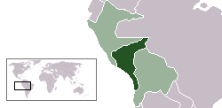
[edit]| Description | Location map of the South Peru within the Peru-Bolivian Confederation | ||||||||
| Date | |||||||||
| Source | Based on Image:Location ConfederaciónPerú-Boliviana.png | ||||||||
| Author | Domino theory | ||||||||
| Permission (Reusing this file) |
I, the copyright holder of this work, hereby publish it under the following licenses:
You may select the license of your choice. |
||||||||
| Other versions | Image:LocationNorthPeru.png |

File history
Click on a date/time to view the file as it appeared at that time.
| Date/Time | Thumbnail | Dimensions | User | Comment | |
|---|---|---|---|---|---|
| current | 04:49, 30 October 2006 | | 250 × 122 (7 KB) | Huhsunqu (talk | contribs) | |
| 14:45, 12 October 2006 |  | 250 × 122 (7 KB) | Domino theory (talk | contribs) | == Summary == {{Information |Description=Location map of the South Peru within the Peru-Bolivian Confederation |Source=Based on [[:Image:Location ConfederaciónPerú-Boliviana.png] |
You cannot overwrite this file.
File usage on Commons
There are no pages that use this file.