File:Location greek ancient.png
Naviqasiyaya keç
Axtarışa keç
Daha yüksək versiyası yoxdur.
Location_greek_ancient.png (248 × 113 piksel, fayl həcmi: 4 KB, MIME növü: image/png)
Captions
Captions
Add a one-line explanation of what this file represents
Xülasə[redaktə]
| İzah |
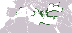
English: Locator map depicting the ancient Greek world, c. 550 BC |
|||
| Tarix | ||||
| Mənbə | Self-created, after http://www.wwnorton.com/nrl/english/nawol/maps/MAP7GRCO.JPG | |||
| Müəllif | User:ChrisO | |||
| İcazə (Faylın təkrar istifadəsi) |
|
|||
| Digər versiyalar |
|


Faylın tarixçəsi
Faylın əvvəlki versiyasını görmək üçün gün/tarix bölməsindəki tarixlərə klikləyin.
| Tarix/Vaxt | Kiçik şəkil | Ölçülər | İstifadəçi | Şərh | |
|---|---|---|---|---|---|
| indiki | 16:20, 27 sentyabr 2021 | | 248 × 113 (4 KB) | Deji Olajide1999 (müzakirə | töhfələr) | Added the missing regions of Orestis, Elimiotis, Eordaia and Tymphaea + cleared up the Greek colonies in Thrace. |
| 09:22, 23 yanvar 2018 |  | 248 × 113 (4 KB) | Maphobbyist (müzakirə | töhfələr) | Added Colchis. | |
| 16:15, 26 iyun 2014 |  | 248 × 113 (6 KB) | SilentResident (müzakirə | töhfələr) | Added missing kingdom of Epirus | |
| 10:55, 29 dekabr 2012 |  | 248 × 113 (5 KB) | Gepgepgep (müzakirə | töhfələr) | Aggiunta l'area di colonizzazione greca dell'Adriatico, che mancava completamente | |
| 17:22, 5 sentyabr 2011 |  | 248 × 113 (5 KB) | Spesh531 (müzakirə | töhfələr) | Showing borders that are recognized. Still showing unrecognized countries for a reference of where Ancient Greek was. It was also about the shape of the lands, as Greek Islands where either not shown correctly or not there at all | |
| 13:00, 5 sentyabr 2011 |  | 248 × 113 (4 KB) | Maphobbyist (müzakirə | töhfələr) | Pfrevious user Saguamundi is right. International borders, and NOT disputed borders must be shown. Nor is this about the present but about historical Greek settlements. There is no place for current politics for a historical map. | |
| 22:28, 4 sentyabr 2011 |  | 248 × 113 (5 KB) | Spesh531 (müzakirə | töhfələr) | Reverted to version as of 01:56, 11 May 2011 The border were fine, your showing territories where some are unrecognizable | |
| 22:21, 4 sentyabr 2011 |  | 248 × 113 (5 KB) | Spesh531 (müzakirə | töhfələr) | Reverted to version as of 01:56, 11 May 2011 The border were fine, your showing territories where some are unrecognizable | |
| 21:26, 4 sentyabr 2011 |  | 248 × 113 (4 KB) | Saguamundi (müzakirə | töhfələr) | Same map but with internationally recognized borders. | |
| 01:56, 11 may 2011 |  | 248 × 113 (5 KB) | Spesh531 (müzakirə | töhfələr) | update more to source, the current Greece was not under territory. |
Siz bu faylı yenidən yükləyə bilməzsiniz.
Fayl keçidləri
Aşağıdakı 3 səhifə bu faylı istifadə edir:
Faylın qlobal istifadəsi
Bu fayl aşağıdakı vikilərdə istifadə olunur:
- en.wikipedia.org layihəsində istifadəsi
- pl.wikibooks.org layihəsində istifadəsi