File:Location map United Kingdom Morecambe Bay.svg
跳转到导航
跳转到搜索

此SVG文件的PNG预览的大小:549 × 600像素。 其他分辨率:220 × 240像素 | 439 × 480像素 | 703 × 768像素 | 937 × 1,024像素 | 1,875 × 2,048像素 | 823 × 899像素。
原始文件 (SVG文件,尺寸为823 × 899像素,文件大小:6.46 MB)
说明
说明
添加一行文字以描述该文件所表现的内容
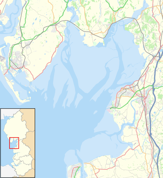
Map of Morecambe Bay in North West England
摘要
[编辑]| 描述 |
English: Map of Morecambe Bay, in Lancashire and Cumbria, England, in 2021.
Geographic limits:
Other road
Railway
River
Woodland
Built-up area |
| 日期 | |
| 来源 |
本文件衍生自: North West England districts 2011 map.svg:
|
| 作者 |
|

许可协议
[编辑]
| This work contains information from OpenStreetMap, which is made available under the Open Database License (ODbL).
The ODbL does not require any particular license for maps produced from ODbL data. Prior to 1 August 2020, map tiles produced by the OpenStreetMap Foundation were licensed under the CC-BY-SA-2.0 license. Maps produced by other people may be subject to other licences. |
本文件采用知识共享署名-相同方式共享 4.0 国际许可协议授权。
署名: © OpenStreetMap contributors, Nilfanion and Dr Greg. Contains Ordnance Survey data © Crown copyright and database right 2021.
- 您可以自由地:
- 共享 – 复制、发行并传播本作品
- 修改 – 改编作品
- 惟须遵守下列条件:
- 署名 – 您必须对作品进行署名,提供授权条款的链接,并说明是否对原始内容进行了更改。您可以用任何合理的方式来署名,但不得以任何方式表明许可人认可您或您的使用。
- 相同方式共享 – 如果您再混合、转换或者基于本作品进行创作,您必须以与原先许可协议相同或相兼容的许可协议分发您贡献的作品。
文件历史
点击某个日期/时间查看对应时刻的文件。
| 日期/时间 | 缩略图 | 大小 | 用户 | 备注 | |
|---|---|---|---|---|---|
| 当前 | 2021年1月23日 (六) 15:46 | | 823 × 899(6.46 MB) | Dr Greg(留言 | 贡献) | Uploaded a work by *North West England districts 2011 map.svg: Nilfanion, created using Ordnance Survey data *OpenStreetMap: [http://www.openstreetmap.org/copyright OpenStreetMap contributors] *derivative work: Dr Greg from {{Derived from|North West England districts 2011 map.svg|display=50}} * http://www.openstreetmap.org/#map=10/54.0960/-3.0336 accessed 21 January 2020 with UploadWizard |
您不可以覆盖此文件。
文件用途
没有页面使用本文件。
全域文件用途
以下其他wiki使用此文件:
- en.wikipedia.org上的用途
- Ulverston
- Heysham
- Morecambe Bay
- Grange-over-Sands
- Fleetwood
- Bolton-le-Sands
- Arnside
- Knott End-on-Sea
- Piel Island
- Islands of Furness
- Roa Island
- Chapel Island
- Walney Island
- Sheep Island (England)
- Foulney Island
- Kents Bank
- Silverdale, Lancashire
- Cockerham
- Rampside
- Bardsea
- Aldingham
- Flookburgh
- Pilling
- Cockersand Abbey
- Morecambe
- Baycliff
- Dova Haw
- Headin Haw
- Newbiggin, Furness
- Canal Foot
- Bay Cycle Way
- Cross Bay Walk
- Module:Location map/data/United Kingdom Morecambe Bay
- Module:Location map/data/United Kingdom Morecambe Bay/doc
- fr.wikipedia.org上的用途
- si.wikipedia.org上的用途
- zh.wikipedia.org上的用途