File:Location map of Bergen County, New Jersey.svg
跳至導覽
跳至搜尋

此 SVG 檔案的 PNG 預覽的大小:700 × 600 像素。 其他解析度:280 × 240 像素 | 560 × 480 像素 | 896 × 768 像素 | 1,195 × 1,024 像素 | 2,389 × 2,048 像素。
原始檔案 (SVG 檔案,表面大小:896 × 768 像素,檔案大小:874 KB)
說明
說明
添加單行說明來描述出檔案所代表的內容
摘要[編輯]
| 描述 |
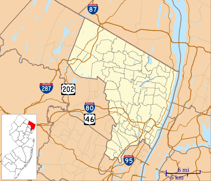
English: This is a map of Bergen County, New Jersey, USA which includes incorporated settlements, township borders, and major highways. |
| 日期 | |
| 來源 | My own work, using custom-written MapScript applications with United States Census Bureau data |
| 作者 | Omnedon |
授權條款[編輯]
| 我,此作品的版權所有人,釋出此作品至公共領域。此授權條款在全世界均適用。 這可能在某些國家不合法,如果是的話: 我授予任何人有權利使用此作品於任何用途,除受法律約束外,不受任何限制。 |
檔案歷史
點選日期/時間以檢視該時間的檔案版本。
| 日期/時間 | 縮圖 | 尺寸 | 用戶 | 備註 | |
|---|---|---|---|---|---|
| 目前 | 2012年10月7日 (日) 22:04 | | 896 × 768(874 KB) | Omnedon(對話 | 貢獻) | == {{int:filedesc}} == {{Information |Description={{en|This is a map of Bergen County, New Jersey, USA which includes incorporated settlements, township borders, and major highways.}} |Source=My own work, using custom-w... |
無法覆蓋此檔案。
檔案用途
沒有使用此檔案的頁面。
全域檔案使用狀況
以下其他 wiki 使用了這個檔案:
- ar.wikipedia.org 的使用狀況
- azb.wikipedia.org 的使用狀況
- رادبرن، نیوجرسی
- والدویک، نیوجرسی
- کرزسکیل، نیوجرسی
- والینقتون، نیوجرسی
- آلندئیل، نیوجرسی
- نیو میلفورد، نیوجرسی
- تئینک، نیوجرسی
- تتربورو، نیوجرسی
- دمئیرست، نیوجرسی
- نورتوئیل، نیوجرسی
- اواکلاند، نیوجرسی
- دومونت، نیوجرسی
- اولد تاپان، نیوجرسی
- ادجواتر، نیوجرسی
- پاراموس، نیوجرسی
- پارک ریدج، نیوجرسی
- وزت وییو، نیوجرسی
- وزتوود، نیوجرسی
- بوقوتا، نیوجرسی
- قلن روک، نیوجرسی
- رامزئی، نیوجرسی
- ریدجفیلد، نیوجرسی
- ریدقیوود، نیوجرسی
- هاکنزاک، نیوجرسی
- ریور ادج، نیوجرسی
- ریور وئیل، نیوجرسی
- کارلستادت، نیوجرسی
- هیلسدئیل، نیوجرسی
- وود-ریدج، نیوجرسی
- هو-هو-کوس، نیوجرسی
- وورتندیک، نیوجرسی
- لیندهورزت، نیوجرسی
- ماهواه، نیوجرسی
- مایوود، نیوجرسی
- ceb.wikipedia.org 的使用狀況
- en.wikipedia.org 的使用狀況
- Allendale, New Jersey
- Alpine, New Jersey
- Bergenfield, New Jersey
- Bogota, New Jersey
- Cliffside Park, New Jersey
- Closter, New Jersey
- Dumont, New Jersey
- Elmwood Park, New Jersey
- Emerson, New Jersey
- Englewood, New Jersey
- Fair Lawn, New Jersey
- Franklin Lakes, New Jersey
- Hasbrouck Heights, New Jersey
- Hillsdale, New Jersey
檢視此檔案的更多全域使用狀況。