File:Location of Lugansk People's Republic (before 2022 invasion).png
Jump to navigation
Jump to search

Size of this preview: 800 × 586 pixels. Other resolutions: 320 × 234 pixels | 640 × 469 pixels | 1,024 × 750 pixels | 1,280 × 938 pixels | 1,694 × 1,241 pixels.
Original file (1,694 × 1,241 pixels, file size: 891 KB, MIME type: image/png)
Captions
Captions
Add a one-line explanation of what this file represents

|
This locator map image could be re-created using vector graphics as an SVG file. This has several advantages; see Commons:Media for cleanup for more information. If an SVG form of this image is available, please upload it and afterwards replace this template with
{{vector version available|new image name}}.
It is recommended to name the SVG file “Location of Lugansk People's Republic (before 2022 invasion).svg”—then the template Vector version available (or Vva) does not need the new image name parameter. |
Summary[edit]
.png&action=edit§ion=1)
| Description |
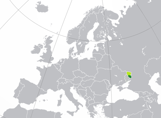
English: territory controlled by the self-proclaimed Lugansk People's Republic (dark green) inside of the Luhansk Oblast (light green) |
| Date | |
| Source |
This file was derived from: Location of Lugansk People's Republic.png |
| Author | Nicolay Sidorov |
Licensing[edit]
.png&action=edit§ion=2)
| This map is ineligible for copyright and therefore in the public domain, because it consists entirely of information that is common property and contains no original authorship. For more information, see Commons:Threshold of originality § Maps.
|
File history
Click on a date/time to view the file as it appeared at that time.
| Date/Time | Thumbnail | Dimensions | User | Comment | |
|---|---|---|---|---|---|
| current | 10:15, 4 October 2022 | | 1,694 × 1,241 (891 KB) | Siradan (talk | contribs) | Uploaded a work by Nicolay Sidorov from {{Derived from|Location of Lugansk People's Republic.png}} with UploadWizard |
You cannot overwrite this file.
File usage on Commons
The following page uses this file:
File usage on other wikis
The following other wikis use this file:
- Usage on ru.wikipedia.org
.png&oldid=723563254)