File:Location of the BOTs.svg
Salta a la navegació
Salta a la cerca

Mida d'aquesta previsualització PNG del fitxer SVG: 735 × 433 píxels. Altres resolucions: 320 × 189 píxels | 640 × 377 píxels | 1.024 × 603 píxels | 1.280 × 754 píxels | 2.560 × 1.508 píxels.
Fitxer original (fitxer SVG, nominalment 735 × 433 píxels, mida del fitxer: 1,26 Mo)
Llegendes
Llegendes
Afegeix una explicació d'una línia del que representa aquest fitxer
Resum[modifica]
| Descripció |
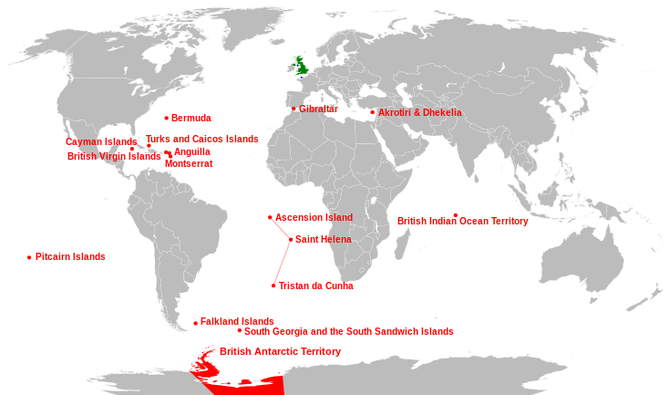
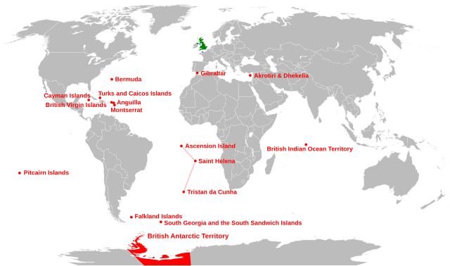
English: Location of the British Overseas Territories (red), Crown dependencies (blue), and Great Britain and Northern Ireland (green) |
| Data | |
| Font |
This file was derived from: |
| Autor | Richardprins |
| Altres versions |
Derivative works of this file: |
| SVG genesis | Aquesta imatge vectorial ha estat creada amb Inkscape, or with something else. |


Llicència[modifica]
| Jo, el titular del copyright d'aquesta obra, l'allibero al domini públic. Això s'aplica a tot el món. En alguns països això pot no ser legalment possible, en tal cas: Jo faig concessió a tothom del dret d'usar aquesta obra per a qualsevol propòsit, sense cap condició llevat d'aquelles requerides per la llei. |
Historial del fitxer
Cliqueu una data/hora per veure el fitxer tal com era aleshores.
| Data/hora | Miniatura | Dimensions | Usuari/a | Comentari | |
|---|---|---|---|---|---|
| actual | 03:30, 29 abr 2024 | | 735 × 433 (1,26 Mo) | Illchy (discussió | contribucions) | File uploaded using svgtranslate tool (https://svgtranslate.toolforge.org/). Added translation for id. |
| 07:01, 29 abr 2015 |  | 735 × 433 (1,28 Mo) | Carnby (discussió | contribucions) | South Sudan border | |
| 22:23, 24 gen 2011 |  | 735 × 433 (1,26 Mo) | Malus Catulus (discussió | contribucions) | fixed country borders | |
| 15:37, 23 gen 2011 |  | 735 × 433 (1,28 Mo) | Malus Catulus (discussió | contribucions) | typo fix and pitcairn location fix | |
| 15:15, 23 gen 2011 |  | 735 × 433 (1,28 Mo) | Malus Catulus (discussió | contribucions) | Changed font size of Antartic... | |
| 15:03, 23 gen 2011 |  | 735 × 433 (1,28 Mo) | Malus Catulus (discussió | contribucions) | Faulty text be fixed, yarrr | |
| 12:48, 23 gen 2011 |  | 735 × 433 (1,26 Mo) | Malus Catulus (discussió | contribucions) | Minor corrections | |
| 16:20, 22 gen 2011 |  | 735 × 433 (1,26 Mo) | Malus Catulus (discussió | contribucions) | few adjustments, corrected Atlantic Ocean Islands | |
| 06:30, 1 oct 2010 |  | 735 × 433 (1,21 Mo) | Pfly (discussió | contribucions) | Attempt to improve graphics of previous edit fix | |
| 06:23, 1 oct 2010 |  | 735 × 433 (1,21 Mo) | Pfly (discussió | contribucions) | Moved British Indian Ocean Territory to correct location. |
No podeu sobreescriure aquest fitxer.
Ús del fitxer
Les 12 pàgines següents utilitzen aquest fitxer:
- Atlas of the United Kingdom
- User:Magog the Ogre/Multilingual legend/2024 April 26-30
- User:Malus Catulus
- File:Location of the BOTs-fr.svg
- File:Location of the BOTs-he.svg
- File:Location of the BOTs-it.svg
- File:Location of the BOTs-mk.svg
- File:Location of the BOTs-pl.svg
- File:Location of the BOTs-pt-br.svg
- File:Location of the BOTs-ru.svg
- File:Location of the BOTs.PNG
- File:Location of the BOTs.png
Ús global del fitxer
Utilització d'aquest fitxer en altres wikis:
- Utilització a af.wikipedia.org
- Utilització a an.wikipedia.org
- Utilització a ast.wikipedia.org
- Utilització a azb.wikipedia.org
- Utilització a az.wikipedia.org
- Utilització a br.wikipedia.org
- Utilització a ca.wikipedia.org
- Utilització a cs.wikipedia.org
- Utilització a da.wikipedia.org
- Utilització a de.wikipedia.org
- Utilització a el.wikipedia.org
- Utilització a en.wikipedia.org
- Utilització a es.wikipedia.org
- Utilització a eu.wikipedia.org
- Erresuma Batua
- Ingalaterra
- Eskozia
- Gibraltar
- Ipar Irlanda
- Gales
- Ascension
- Santa Helena
- Falklandak
- Man
- Jersey
- Guernesey
- Hegoaldeko Georgiak
- Pitcairn uharteak
- Hegoaldeko Sandwichak
- Hegoaldeko Georgiak eta Hegoaldeko Sandwichak
- Birjina britainiar uharteak
- Bermuda
- Kaiman uharteak
- Montserrat (uhartea)
- Turkak eta Caicoak
- Aingira (dependentzia)
- Txantiloi:Erresuma Batuko lurralde antolaketa
- Akrotiri eta Dhekelia
Vegeu més usos globals d'aquest fitxer.