File:Locator map Tutong in Brunei.svg
Jump to navigation
Jump to search

Size of this PNG preview of this SVG file: 527 × 599 pixels. Other resolutions: 211 × 240 pixels | 422 × 480 pixels | 676 × 768 pixels | 901 × 1,024 pixels | 1,802 × 2,048 pixels | 938 × 1,066 pixels.
Original file (SVG file, nominally 938 × 1,066 pixels, file size: 104 KB)
Captions
Captions
Add a one-line explanation of what this file represents
This W3C-unspecified vector image was created with Inkscape .
Summary
[edit]
| Description | |
| Date | |
| Source | Brunei map-en.svg |
| Author | Tachymètre (talk) |
Licensing
[edit]
| This work has been released into the public domain by its author, Tachymètre. This applies worldwide. In some countries this may not be legally possible; if so: |
File history
Click on a date/time to view the file as it appeared at that time.
| Date/Time | Thumbnail | Dimensions | User | Comment | |
|---|---|---|---|---|---|
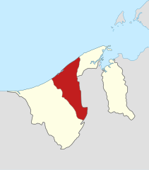
| current | 14:00, 26 February 2011 | | 938 × 1,066 (104 KB) | Tachymètre (talk | contribs) | {{Created with Inkscape}} == {{int:filedesc}} == {{Information |Description= {{en|Locator map of Tutong in Brunei.}} {{de|Lage von Tutong in Brunei.}} {{fr|Carte géolocalisée de [[:fr: |
You cannot overwrite this file.
File usage on Commons
The following page uses this file:
File usage on other wikis
The following other wikis use this file:
- Usage on ar.wikipedia.org
- Usage on ast.wikipedia.org
- Usage on bcl.wikipedia.org
- Usage on bg.wikipedia.org
- Usage on bn.wikipedia.org
- Usage on cs.wikipedia.org
- Usage on de.wikipedia.org
- Usage on de.wikivoyage.org
- Usage on el.wikipedia.org
- Usage on en.wikipedia.org
- Usage on es.wikipedia.org
- Usage on eu.wikipedia.org
- Usage on fi.wikipedia.org
- Usage on frr.wikipedia.org
- Usage on fr.wikipedia.org
- Usage on he.wikipedia.org
- Usage on id.wikipedia.org
- Daerah Tutong
- Pekan Tutong
- Mukim Keriam
- Mukim Kiudang
- Mukim Telisai
- Mukim Ukong
- Mukim Lamunin
- Mukim Rambai
- Mukim Tanjong Maya
- Mukim Pekan Tutong
- Kampung Bukit Panggal
- Kampung Penanjong
- Kampung Tanjong Maya
- Kampung Penapar
- Kampung Maraburong
- Kampung Sungai Kelugos
- Kampung Keriam
- Kampung Ikas
- Kampung Kupang
- Kampung Luagan Dudok
- Kampung Sinaut
- Kampung Bakiau
- Kampung Batang Mitus
- Kampung Birau
- Kampung Kebia
- Kampung Luagan Timbaran
- Kampung Mungkom
- Kampung Pad Nunok
- Kampung Pangkalan Mau
- Kampung Kiudang
- Kampung Bukit
- Kampung Telisai
- Kampung Bintudoh
View more global usage of this file.