File:Loenermark 3.jpg
Jump to navigation
Jump to search

Size of this preview: 800 × 599 pixels. Other resolutions: 320 × 240 pixels | 640 × 479 pixels | 1,024 × 767 pixels | 1,280 × 959 pixels | 2,177 × 1,631 pixels.
Original file (2,177 × 1,631 pixels, file size: 1.13 MB, MIME type: image/jpeg)
Captions
Captions
Add a one-line explanation of what this file represents
Summary
[edit]
| Description |
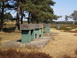
Nederlands: IJkbasis (buiten gebruik) om geodetische meetinstrumenten mee te ijken, gebouwd in 1957. Lengte: 576,09226 m. Locatie: Zilvensche heide; zuidwestelijk gedeelte van natuurgebied de Loenermark, Zuid-Veluwe, Gelderland (NL)
English: Base line (out of use), built in 1957 as a reference for geodetic distance measurement equipment. Length: 576.09226 m. Location: Zilvensche heide; southwestern part of nature reserve Loenermark, South Veluwe, Gelderland (NL) |
| Date | |
| Source | Own work |
| Author | Apdency |
| Camera location | | View this and other nearby images on: OpenStreetMap |
|---|
Licensing
[edit]
| I, the copyright holder of this work, release this work into the public domain. This applies worldwide. In some countries this may not be legally possible; if so: I grant anyone the right to use this work for any purpose, without any conditions, unless such conditions are required by law. |
File history
Click on a date/time to view the file as it appeared at that time.
| Date/Time | Thumbnail | Dimensions | User | Comment | |
|---|---|---|---|---|---|
| current | 10:28, 28 July 2010 | | 2,177 × 1,631 (1.13 MB) | Apdency (talk | contribs) | == Summary == {{Information |Description={{nl|IJkbasis (buiten gebruik) om lengtematen mee te ijken, gebouwd in 1957. Lengte: 576,09226 m. Locatie: Zilvensche heide; zuidwestelijk gedeelte van natuurgebied de Loenermark, Zuid-Veluwe, Gelderland (NL)}} {{e |
You cannot overwrite this file.
File usage on Commons
There are no pages that use this file.
File usage on other wikis
The following other wikis use this file:
- Usage on ceb.wikipedia.org
- Usage on nl.wikipedia.org
- Usage on www.wikidata.org